
Image to G-Code. Before the g-code file is created the size of the carving dimensions and the maximum tool depth can be increased or decrease without the need to reprocess the image.
Image resolution can also be adjusted using several methods like the k-factor, axis combine, reverse, close enough and the x and y axis resolution. Prep-code and post-code can be edited with the G-Code Editor built into the application for easy access and more. Image to G-Code can convert raster images to vectors also.
Image to G-Code also imports DXF files from most CAD programs. (AutoCAD release 12 compatible), the importer support most geometric entities including inserts [with nested blocks]. Image to G-Code also includes a little CAD drawing editor that allows you to modify imported DXF-Files, convert True Type Fonts to vectors, and draw lines, circles, polygons, arcs and more. The National Map Seamless Server Viewer. USGS TNM 2.0 Viewer. ImageCarve. Creating 3D terrain maps with ArtCAM Pro « K6123932 for Kamonrato.
ArtCAM can very easily be used to create terrain maps from USGS data files.
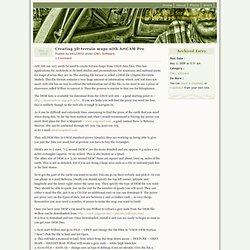
This has applications for Architects to do land studies and presentations, for museums and national parks for maps of areas they are in. The starting file format is called a DEM file (Digital Elevation Model). This file format contains a very large amount of information, which ArtCAM does not need. ArtCAM has no way to extract the information out of the file, so we need to use a piece of shareware called Wilbur to convert it. Then the process is similar to that use for lithophanes. The DEM data is available for download from the USGS web site – a good starting point is – If you are lucky you will find the piece you need for free, this is unlikely though as the web site is tough to navigate in. As it can be difficult and extremely time consuming to find the piece of the earth that you need when doing this, by far the best method and what I would recommend is buying the pieces you need. 1. 1. Like this: Converting Digital Elevation Models To Shapefile/DXF Contours.
There are any number of ways to convert a digital elevation model (DEM) to shapefile vector contour lines, but most of the ones I’ve come across have had limitations of one sort or another.
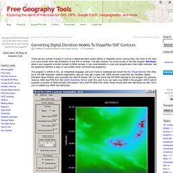
The best solution I’ve come across is the free program dem2topo; while it only supports a limited number of DEM formats, it has more flexibility in units and simplification than other methods, and the graphical interface is easy to use (unlike some command-line programs). The program is written in IDL, an interpreted language, and you’ll have to download and install the IDL Virtual Machine first (free, but a 100 MB download, requires registration, and you may get a sales call). DEM formats supported are Canadian Digital Elevation Data (CDED), and nominally the GeoTiff format, but I’ve had some GeoTiff DEM rejected by the program for unknown reasons.
A simple process, and if you run into problems, the help file is well done.