
Latitude Longitude From Address. Free Zipcode Database. Geographic Append Services - Rooftop Geocoding. Append precise rooftop latitude and longitude information to the U.S. and international street addresses that you have gathered in your mailing list, website, or other business contact-dependent process.
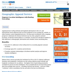
Use these geo-coordinates with a mapping program to determine the distance between any two sites, pinpoint customer locations, or find the closest dealer to a customer. Use the tract and block numbers to link addresses to demographic information and valuable Census marketing data. Benefits: Geocode U.S. addresses to the rooftop level to accurately pinpoint customer locations Coverage spans 40+ countries and territories Visualize customer relationships to facilitate market analysis and improve business intelligence U.S. Melissa Data’s service provides the GeoPoints for 95% of all U.S. delivery addresses (business and residential). Find Latitude and Longitude. Using OpenRefine to geocode your data with Google and OpenStreetMap API. In the previous article we saw how to take our comma-separated list of google contacts, and play with them using OpenRefine.
We learned how to do things like filtering, faceting, normalizing data, removing duplicate rows and other pretty common tasks. In this article we will see how to use OpenRefine to enrich our datasets with data from any web service available on line. We will geocode each contact using google maps web service. For each address we will get the whole json response and we will learn to parse it, extract the coordinates, and save them in a latitude and longitude columns. This is how our dataset looked like after all the cleaning up we did in our previous article. You can see that we have an address column that we are going to use for georeferencing. A good advice before georeferencing a dataset, is to pick a couple of known addresses and test them on the web service. In our case, all the addresses are from Buenos Aires, Argentina. The formula is pretty simply.
Digital Geography. Batch Geocode Addresses from a Google Spreadsheet. Load worksheet data To find the spreadsheet and worksheet ID for your Google spreadsheet: Save and publish the spreadsheet (Warning!
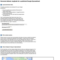
Don't publish private data!) Click on "More Publishing Options," change file format to ATOM & generate URL Find the parts of the URL that match the example below and paste them in. Click "Load Worksheet Data" button when done. Pick column names Please choose one column that has descriptive information (to help you identify the locations) and one column containing the addresses of the locations.
Google Spreadsheet Geocoding Macro. The Google Geocoding API - Google Maps API Web Services. The Google Maps Geocoding API is a service that provides geocoding and reverse geocoding of addresses.
Geocoding is the process of converting addresses (like a street address) into geographic coordinates (like latitude and longitude), which you can use to place markers on a map, or position the map. Reverse geocoding is the process of converting geographic coordinates into a human-readable address. You can also use the Google Maps Geocoding API to find the address for a given place ID. Sample request and response You access the Google Maps Geocoding API through an HTTP interface. Geocoding request and response (latitude/longitude lookup) The following example requests the latitude and longitude of "1600 Amphitheatre Parkway, Mountain View, CA", and specifies that the output must be in JSON format. You can test this by entering the URL into your web browser (be sure to replace ‘YOUR_API_KEY’ with your actual API key). Below is a sample geocoding response, in JSON: ... ], "status" : "OK"} Quotas. OpenCage Geocoder - API docs. Quick Start Sign up for your free key.
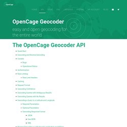
Forward geocoding: Reverse geocoding: For all the details of alternate formats, pretty output, response codes, etc. please see below: SmartyStreets. Free Shapefiles - US DataMart. Download US State shapefiles including District of Columbia Download US County shapefile definitions Download US Census Tract shapefile definitions Download US Census Block Group shapefile definitions Download US Census ZCTA5 shapefile defintions Download US State shapefiles including District of Columbia.
Geocode. Geocoder - The almost missing Geocoder PHP library! Important: You are browsing the documentation of Geocoder 3.x.
Documentation for version 2.x is available here: Geocoder 2.x documentation. Geocoder is a PHP library which helps you build geo-aware applications by providing a powerful abstraction layer for geocoding manipulations. Installation The recommended way to install Geocoder is through Composer: $ composer require willdurand/geocoder Usage. Mapping Software Products, API, Geocoder. Geocoder Purchase. Welcome to Geocoder. Geocodio. Batch geocoding. Use this page to geocode a large number of addresses, postcodes or ZIP codes.
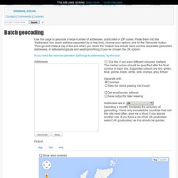
Paste them into the 'Addresses' box (each address separated by a new line), choose your options and hit the 'Geocode' button. Then go and make a cup of tea and when you return the 'Output' box should have comma separated geocoded addresses, in latitude/longitude and easting/northing (if you've chosen the UK option). If you need the reverse operation (lat/longs to addresses), try this tool. Addresses Separate with Selecting a country increases the accuracy of geocoding. Output Map DataMap data ©2014 GeoBasis-DE/BKG (©2009), Google, basado en BCN IGN España. Batch Geocode.