
Inside New York’s Most Beautiful Subway Station, Abandoned Since 1945. Old City Hall Station (all photos by the author for Hyperallergic) Postcard of the “underground loop at City Hall, New York” (early 1900s) (via Wikimedia) (click to enlarge) I recently had the opportunity to join one of these tours, led by historian John Simko, who first showed us the site of what is technically the city’s first subway (Alfred Ely Beach’s 1869 one-stop pneumatic tunnel), as well as the remains of the station above ground, including some glass panels in City Hall Park that illuminate the skylights.
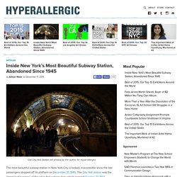
A view down the platform today The station is remarkably intact, its ornate glass oculus still shining on the mezzanine where the ticket booth once stood, and the herringbone terra-cotta tile work in green and white brightly accenting the arches designed by Rafael Guastavino. Like all of the first IRT stations, it was created with architects Heins & LaFarge. The mezzanine of the old City Hall Station, with its glass oculus A 6 train making the loop in old City Hall Station. » The first aerial photograph of Lower Manhattan. NYC Fractal. Le photographe allemand Carsten Witte nous propose de découvrir cette série de clichés appelée « NYC Fractal ».

Passionné par les buildings de New York, l’artiste nous propose des images de surfaces et de façades de bâtiments où formes se marient aux reflets. NYC Municipal Archives.
Hurricane Sandy: After Landfall - In Focus. Last night, Hurricane Sandy -- the largest Atlantic tropical system on record -- made landfall just south of Atlantic City, New Jersey, bringing winds up to 90 mph (150 kph), and pushing a massive storm surge onto beaches and shorelines.

At least 12 deaths have been reported in the United States. These fatalities, when added to the previous toll in the Caribbean, leave Sandy responsible for more taking more than 80 lives to date. Millions across the Eastern Seaboard are now without power, and even more are struggling with rising floodwater. Sandy continues northward, now downgraded to a post-tropical cyclone, and those affected are now assessing the damage. NYC Unplugged, Long Exposure Photos of New York City During the Power Outage Blackouts. Aerial Views of the Sandy Blackout. The editor's letter in this week's New York Magazine tells the story of how the staff put the issue together after our downtown offices were flooded.
Here is the story of how the striking photo on the cover of the issue came together. As we considered the different opportunities for imagery on Wednesday, it quickly became clear that one option was a picture of the island of Manhattan taken from the air, showing the clear delineation of lights on and off in different parts of the city. We called Iwan Baan, one of our contributing photographers, to see if he happened to be in New York at the moment. (He is based out of Amsterdam, but travels the world, and often stops by New York.) Baan's photography focuses primarily on contemporary architecture and its relationship to the urban language of the city. Fortunately, Baan was in town last week and had prepared for the storm. But when he got to Hertz in Manhattan, they had run out of vehicles. Then he had to track down a helicopter. The Best Aerial Image of New York City You'll Ever See - Alexis C. Madrigal.
This is a great image of a city that seems designed to bring great images into being. Sergey Semonov, a Russian photographer, submitted the image to the Epson International Photographic Pano Awards , and took first prize in the amateur category. Semonov works on a small noncommercial team called AirPano , which travels the globe creating these 3D aerial panoramas . They shoot from helicopters and then stitch the images together. Mostly, they produce these spherical panoramas that I find confusing to navigate, but clearly this one has been flattened for our viewing pleasure.