
Video Séisme au Japon : explications de spécialistes. C'est quoi l'échelle de Richter ? 22 February 2011Last updated at 17:44 There are thousands of earthquakes around the world each year, but only a few cause serious damage.
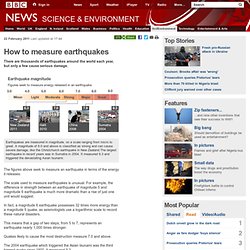
The figures above seek to measure an earthquake in terms of the energy it releases. The scale used to measure earthquakes is unusual. For example, the difference in strength between an earthquake of magnitude 5 and magnitude 6 earthquake is much more dramatic than a rise of just one unit would suggest. In fact, a magnitude 6 earthquake possesses 32 times more energy than a magnitude 5 quake, as seismologists use a logarithmic scale to record these natural disasters. This means that a gap of two steps, from 5 to 7, represents an earthquake nearly 1,000 times stronger. Quakes likely to cause the most destruction measure 7.0 and above. The 2004 earthquake which triggered the Asian tsunami was the third biggest quake since 1900. There are an estimated 20 major quakes in the world every year according to the US Geological Survey. Pourquoi ce séïsme. Seisme-au-japon épicentre Le séisme qui vient de survenir au Japon - lire ici une note avec les premières informations - s'explique par la tectonique des plaques.

Le Japon fait face à une menace sismique (et volcanique) importante et quasi permanente à l'échelle des temps géologiques. La cause en est connue, l'archipel japonais se situe à la frontière de trois plaques tectoniques : les plaques Pacifique, eurasienne et des Philippines dont les interactions en font l'une des zones les plus actives de la planète. Surtout «la plaque Pacifique glisse sous le Japon à une vitesse de 8 cm par an», m'explique au téléphone Xavier Le Pichon, Professeur honoraire au Collège de France qui a conduit des études dès les années 1980, avec le sous marin de l'Ifremer le Nautile, sur les zones de failles.
Depuis leur laboratoire du CEREGE, à Aix en Provence, Pierre Henry poursuit les explications. Les traces de séismes des 800 dernières années, comme ceux de la période plus récentes où les Plaques tectoniques. Seisme : comment ça marche ? Les tsunamis dans le monde depuis 2004 - CATASTROPHE NATURELLE. Pire qu'à Sumatra. West Coast and Alaska Tsunami Information.
COMET - Centre for the Observation and Modelling of Earthquakes and Tectonics. John Elliott, Zhenhong Li, Richard Walters, Barry Parsons COMET+ researchers are investigating the ground deformation associated with the recent Yushu earthquake using satellite radar measurements.
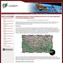
They intend to model the distribution of subsurface slip in order to improve our understanding of faulting and seismic hazard Background On the 13th April 2010, a magnitude 6.9 earthquake struck the relatively remote region of Western China, in the county of Yushu at the eastern end of the Tibetan Plateau at about 4000 m elevation. Despite the low population density, approximately 2200 are thought to have died in this event, with over 10,000 injured. Figure 1: Fault map of Tibet laid over LANDSAT satellite imagery for the Tibetan Plateau and western China.
InSAR Observations of Ground Deformation Interferometric Synthetic Aperture Radar (InSAR) is a satellite based technique which can provide measurements of ground motion in an earthquake. Ground Deformation Profiles. Un seisme d'ampleur surprenante. The magnitude 8.9 earthquake that struck Friday off the coast of Japan "is going to be among the top 10 earthquakes recorded since we have had seismographs," said seismologist Susan Hough of the U.S.

Geological Survey in Pasadena. "It's bigger than any known historic earthquake in Japan, and bigger than expectations for that area. " Geologists had expected the portion of the Pacific "Ring of Fire" that produced this quake to yield a temblor on the order of magnitude 8 or perhaps 8.5, she said. "Something as big as an 8.9 is a bit of a surprise," she said. A quake that big usually requires a long, relatively straight fault line that can rupture, such as those found in Peru and along the eastern coast of South America. Photos: Scenes from the earthquake Scientists did not expect such a big quake in the area because the plate boundary is not straight, but is fairly irregular. The region had a magnitude 7.2 temblor Wednesday in almost exactly the same area. Thomas.maugh@latimes.com.