Micmac - LOGICIELS. Pour chaque problème de mise en correspondance rencontré à l’IGN, il existe une solution opérationnelle ad hoc en œuvre mais, compte tenu de la diversité apparente des problèmes, il n’existe pas d’approche unique.
Dans le contexte de soutien à la recherche en traitement d’images à l’IGN, a émergé le besoin d’un outil fournissant une solution générale aux principales applications cartographiques de mise en correspondance. L’objectif du logiciel MicMac est donc de fournir une solution unifiée permettant de répondre à la majorité de ces problèmes. La stratégie générale utilisée par MicMac est la suivante : approche multi-résolution et, à une résolution donnée, approche par minimisation d’une fonction d’énergie combinant attache aux données et connaissances a priori sur la régularité. Au-delà de ces caractéristiques générales, un système de paramétrage par fichier xml permet d’offrir à l’utilisateur un contrôle fin de l’ensemble du processus de mise en correspondance. Topcon Positioning Systems, Inc. Previously PI-3000 ImageMaster software is available in four editions, IS, Lite, Standard, Pro.
This powerful combination of functionality allows you to accomplish everything from Imaging Station wireless control of measurements to 3D module generation using stereo photo pairs. Imaging, scanning and photogrammetry projects come to life in this powerful PC software. Internet Archaeol. 25. Review of ImageMaster. Anthony Masinton. Dept.
Archaeology, University of York. Email: awm106@york.ac.uk Cite this as: A. Masinton 2008 'Review of ImageMaster Close-Range Photogrammetry Software by Topcon', Internet Archaeology 25. UK availability and pricing from TerraDat GeomaticsMinimum system requirements: 32 bit Windows 98, ME, 2000, XP; Pentium 4 2.0 GHz; 512Mb RAM; minimum 5 Megapixel digital camera. Introduction | ImageMaster | Caveats | Workflow | Summary and Conclusions 1. With the release of Photosynth, Microsoft has taken the quest for the 'holy grail' of close-range photogrammetry one step closer to its goal while also placing that goal in the hands of non-specialists.
The quest continues. Some steps have already been taken to bridge the gap between professional-grade photogrammetry and non-specialists. The negative side of all of these tools is that they are web-based. Relatively inexpensive (about £800) local machine solutions have been available for many years. Free and Open Source Software (FOSS) The Free and Open Source Software (FOSS) model provides interesting tools and processes with which women and men can create, exchange, share and exploit software and knowledge efficiently and effectively.
FOSS can play an important role as a practical instrument for development as its free and open aspirations make it a natural component of development efforts in the context of the Millennium Development Goals (MDGs). In the area of software, UNESCO’s fulfills its basic functions of a laboratory of ideas and a standard-setter to forge universal agreements on emerging ethical issues by supporting the development and use of open, interoperable, non-discriminatory standards for information handling and access as important elements in developing effective infostructures that contribute to democratic practices, accountability and good governance. UNESCO recognizes that: Menci Software. Pix4D. Close-range photogrammetry and image-based modeling. EnsoMOSAIC - photogrammetric software and aerial imaging system.
Www.agisoft.ru. September 2012. I came back few weeks ago from the archaeological excavation of Çatalhöyük, Turkey where this year I tried new experiments in the use of 3D technology to document and visualize ongoing archaeological excavations.
Last year I did tests on site using Image Based Modeling techniques to document the investigation of the building 89, in that occasion the team of the university of California Merced directed by Maurizio Forte, were running similar experiments using instead a phase shift laser scanner, they got interesting results and the use of both these techniques in the same excavation context gave us a very good feedback on how different technologies that produce similar results (resolute 3D model) obey to different work-flow of data capturing and post processing. After this tests we gain a good knowledge on how making these tools compatible with ongoing excavations and how to manage the data in a reasonable time frame. 3D model of the Building 77 realized using Photoscan AgiSoft.
PhotoScan – Basic Processing for Photogrammetry. This series will show you how to create 3d models from photographs using Agisoft Photoscan and Esri ArcGIS.
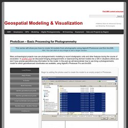
Hint: You can click on any image to see a larger version. Many archaeological projects now use photogrammetric modeling to record stratigraphic units and other features during the course of excavation. In another post we discussed bringing photogrammetric or laserscanning derived models into a GIS in situations where you don’t have precise georeferencing information for the model. In this post we will demonstrate how to use bring a photogrammetric model for which georeferenced coordinates are available, using Agisoft’s Photoscan Pro and ArcGIS. Load Photos Begin by adding the photos used to create the model to an empty project in Photoscan.
Align Photos Following the Photoscan Workflow, next align the images.