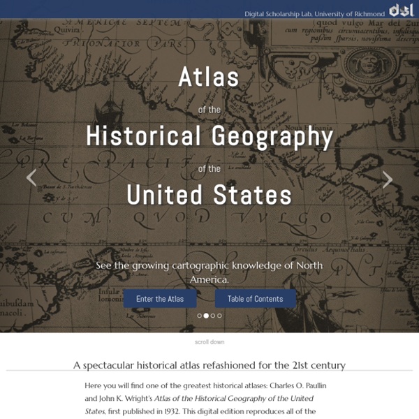
Atlas of the Historical Geography of the United States
David Rumsey Historical Map Collection
Iran, US, Europe start implementing nuclear deal
TEHRAN, Iran (AP) — Iran unplugged banks of centrifuges involved in its most sensitive uranium enrichment work on Monday, prompting the United States and European Union to partially lift economic sanctions as a landmark deal aimed at easing concerns over Iran's nuclear program went into effect. The mutual actions — curbing atomic work in exchange for some sanctions relief — start a six-month clock for Tehran and the world powers to negotiate a final accord that the Obama administration and its European allies say will be intended to ensure Iran cannot build a nuclear weapon. In the meantime, the interim deal puts limits on Iran's program — though it continues low levels of uranium enrichment. Tehran denies its nuclear program is intended to produce a bomb. The payoff to Iran is an injection of billions of dollars into its crippled economy over the next six months from the suspension of some sanctions — though other sanctions remain in place. View gallery Dahlburg reported from Brussels.
History in Motion
Land of Opportunity
Maps Library of Congress
↓ Refine your search [Shandong, Zhili, Shengjing hai jiang tu] Scale ca. 1:125,000. Title supplied. Oriented with north to the left. Relief shown pictorially. Pictorial map. De Eylanden en Vastelanden van Westindien / Relief shown pictorially.
Google Earth Timelapses and Historical Imagery
Google Earth Pro (the desktop version of Google Earth) has offered historical imagery for many years. You can access that imagery by selecting the timeslider icon in the menu at the top of Google Earth when it is open on your desktop. Today, Google unveiled some updates to their Google Earth Engine Timelapse website that offers historical imagery in an online version of Google Earth. The timelapses are animations that play 35 years of satellite imagery. Applications for Education The timelapse and historical imagery could be useful in a science class to help students see how coastlines and other features of landscapes change over time.
Anti-Eviction Mapping Project
topoView | USGS
Accessing USGS topographic maps has never been easier TopoView highlights one of the USGS's most important and useful products, the topographic map. In 1879, the USGS began to map the Nation's topography. This mapping was done at different levels of detail, to support various land use and other purposes. As the years passed, the USGS produced new map versions of each area. This interface was created by the National Geologic Map Database project (NGMDB), in support of topographic mapping program managed by the National Geospatial Program (NGP). Packed with new features and downloadable file formats The maps shown through topoView are from the USGS’s US Topo series and earlier Historical Topographic Map Collection (HTMC). The goal of the HTMC, which started in 2011, is to provide a digital repository of USGS 1:250,000 scale and larger (more detailed) maps printed between 1884 (the inception of the topographic mapping program), and 2006. Send us your feedback
James Farmer Project
Jeffrey W. McClurken | A Starting Place for My Digital Work
Remembering Rondo | A History Harvest
Rondo Avenue no longer looks like the thriving economic main street of St. Paul's historically Black community. Old Rondo Avenue, the social and cultural heart of a vibrant community, is now I-94, the national highway connecting the Twin Cities. In the 1950s, St. Paul intentionally cut the highway through the Rondo neighborhood. This History Harvest is focused on Remembering Rondo. This archive is made for the Rondo neighborhood, by the Rondo neighborhood, but we hope that others will find it relevant as well. Featured Item Soup Tureen Flowered top, bowl, and ladle of soup tureen. Featured Collection Joyce P.
Making the History of 1989
The Fall of Communism in Eastern Europe IntroductoryEssay Sets the scene for the events of 1989 and explains their significance in world history. PrimarySources Over 300 primary sources, including government documents, images, videos, and artifacts with introductory notes. ScholarInterviews Four scholars focus on the history & events surrounding 1989 through primary sources. TeachingModules Modules provide historical context, strategies, and resources for teaching the history of 1989 with primary sources. CaseStudies Teaching case studies provide historical context and strategies for teaching the history of 1989 with primary sources. Advanced Search About this Site © 2007–2016 Roy Rosenzweig Center for History & New Media Powered by Omeka
Enchanting the Desert | Home
Related:
Related:
