
Inspirational Quotes / Motivational Quotes / Quotes to live by This site is not suppose to look like this, it's suppose to be a little more fun. You are probably using an old browser like Internet Explorer (Shame on you). Use the latest versions of Firefox, Safari or Chrome instead. 12 Beautiful Websites with Big Maps Maps are not only a resource for the contact section, sometimes a well-designed map helps to create beautiful and innovative websites.In the next post we have selected 12 wonderful websites with large maps. Enjoy! Mensages for Japan The Bullitt Agency Ivan Rodic NL Engenharia BlueCadet Keystone Pix FX Porto Alegre Studio Moso Coal Headwear Design Royale World of Merix
National Geographic shares rich map content with the world via Google Maps Engine (Cross-posted from the Google Enterprise Blog) Editor's note: Today’s guest blog is about the newly launched Google Maps Engine public data program, which lets organizations distribute their map content to consumers using Google’s cloud infrastructure. Frank Biasi, Director of Digital Development at National Geographic Maps, tells us how his organization is participating in the public data program and sharing over 500 maps to the world. Why are maps important for National Geographic? Founded in 1888, National Geographic Society aims to inspire people to care about the planet. As one of the world’s largest nonprofit scientific and educational organizations, we’ve funded more than 10,000 research, conservation and exploration projects.
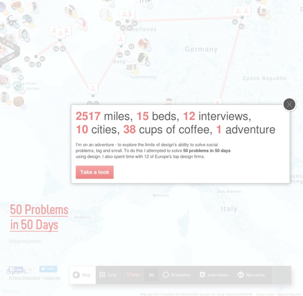
Map your moves Data This map distills more than 4000 moves from over 1700 people, collected in an informal survey by WNYC, a New York based public radio station. For generating the geo–coordinates from the entered ZIP codes, I used the free bulk geocoder at gpsvisualizer.com. I did not check every single data row in detail, so a few of the moves might be misrepresented. Mapping As most moves occurred from, to or within the New York area, this area displayed enlarged in the white circle at the center of the graphic. 30 Superb Examples of Infographic Maps As you search the web you’ll come across a wide range of interactive and graphical maps. Deciding when, where and how to integrate or display a map on your site is the first step, the second should be what technology and illustrations to use. If you’re all about interaction, JQuery, Ajax, or Flash are all effective technologies that hold their own ground.
Ascii Street View Ascii Street View Real-time Ascii Art conversion of Google Street View panorama's done in WebGL. You'll need Chrome, Firefox 8+, or another browser that supports CORS WebGL textures. Coded by @peter_nitsch. swissnex Boston Project Leader for new “swissnex mobile” at the EXPO Astana 2017 in Kazakhstan swissnex Boston together with Presence Switzerland (PRS) is looking for a Project Leader for the new “swissnex mobile” at the EXPO Astana 2017 in Kazakhstan. It is a new, unique approach for swissnex to be part of the official Swiss Pavilion at a world exhibition. The topic is centered around energy and a (former) link to swissnex is of advantage for this position.
Designers checklist advices — Project by Adrien Heury 10/10Be proud of your work Anton RepponenCreative director • Fantasy interactive • NYC I know so many designers who aren't happy with their work at the end of a project. “It might have been so much cooler,” they say. "If only I'd known that this would be the final result”. Mapping the City « Design Influence “In their tendency to persist even in the context of geographically homogenizing forces, place differences permeate the artifacts whose creation they stimulate. … The mechanisms through which such diverse elements combine into a local industrial atmosphere shape not just competitive advantage of one place over another in producing a given artifact, but the nature of goods that can come into existence.”—New York University sociologist Harvey Molotch, quoted in The Atlantic—Cities. City Maps shows an unexpected view of the streets of Austin, New York and San Francisco by mapping the city using logos. The app is linked to Foursquare, Twitter and deals so you can be fully connected with the activity surrounding you.