
https://www.aabsys.com/insights/aabsys-specializations/3-gis-services/
Related: kalpanajain11 • ranjujain • Services & Application3d Walkthrough Animations at AABSyS The housing and urban development industry utilise CAD and GIS services provided at AABSyS to generate 3D Models that are useful in study, design and planning of constructed space. The Architectural 3D modeling services are important feature for understanding a building’s architecture. They assist in easy visualization of the exteriors of a residential house, apartment, office, restaurant, and hotel. The Architectural 3D modeling helps AABSyS’s customers to visualize the property for better decision making for selling, leasing, or renting out a house or an office. They present a powerful overview of the actual architectural structure before or after its construction. The architectural floor plans with wall textures, colour schemes can be utilized for a better understanding of the exteriors of the building, house, office etc.
Blockchain Development Services AABSyS offers reliable and accurate Blockchain Development services, for customers globally. Blockchain technology enhances the security of transactions, allows content to be distributed without being misused and above all, maintains a secure decentralized repository of information. AABSyS provides end to end services for blockchain development from the secure decentralized solutions to integration of blockchain-based modules into the existing software in order to ensure data integrity and compliance. The following Blockchain Development services are offered:
3d Walkthrough Animations at AABSyS AABSyS creates customised 2D animations, 3D animations and 3D walkthroughs for the architecture and construction industry. A 3D walkthrough is the best solution to create a visual impact of an architectural structure. It depicts the interior and exterior landscapes of office buildings, residential complexes, and other visuals before the actual construction of the project. The 3D walkthrough animation can also be used in various forms such as presentation of client’s products and services in various media like television, websites, digital video commercials or innovative designs for print, DTP. 3D Exterior landscaping is created with proper placement of roads, vehicles, trees, fences, and other objects. The layout and designs of the rooms are arranged as per the customers plans provided.
AutoCAD Drafting Services at AABSyS AutoCAD Drafting services assist real estate developers, architects, engineers and contractors in creating a computerised version of the blue print, design, layout etc. They are easy to store, edit and share and therefore have become popular mode of data digitisation. The services offer high accuracy with no loss of data. Utility Right of Way Mapping Services A utility right of way is a registered easement on private land that allows the local administration and various utility companies the right to access the utilities or services that are routed within the right of way. Utility rights of way usually contain underground or overhead supply lines of utility services such as electric power, water, sewer, telephone, and gas. Utility Right of Way survey or Route survey is carried out to determine and layout the route of a utility link from the distributer to the customer’s home or office. AABSyS IT has a strong expertise in providing utility right of way mapping services. The specialised team for route survey visits the site to analyze and understand the route survey plan.
Municipal GIS Services for Municipality Tasks at AABSyS AABSyS has been working with the local and national governmental organisations for a long time now and understands the uniqueness and confidentiality of governmental work. Many government aided bodies are recurring clients of AABSyS, as AABSyS provides a unique platform for generating timely and cost effective deliverables. The work involves GIS services such as georeferencing, satellite image processing, image classification, digitization, attribution, theme creation, map preparation, data analysis and report generation, computer aided designing and drafting services and remote sensing services. Cadastral Mapping Services at AABSyS Cadastral mapping is a comprehensive register of the details related to the property of an area. These details include the precise location, dimensions, and other geographical classifications of the properties or individual parcels of land. The maps generated using cadastral mapping services help in effective management of public land records. National and local governmental bodies, architecture and engineering firms, real estate developers, industries can uses the cadastral mapping services for making well informed decisions.
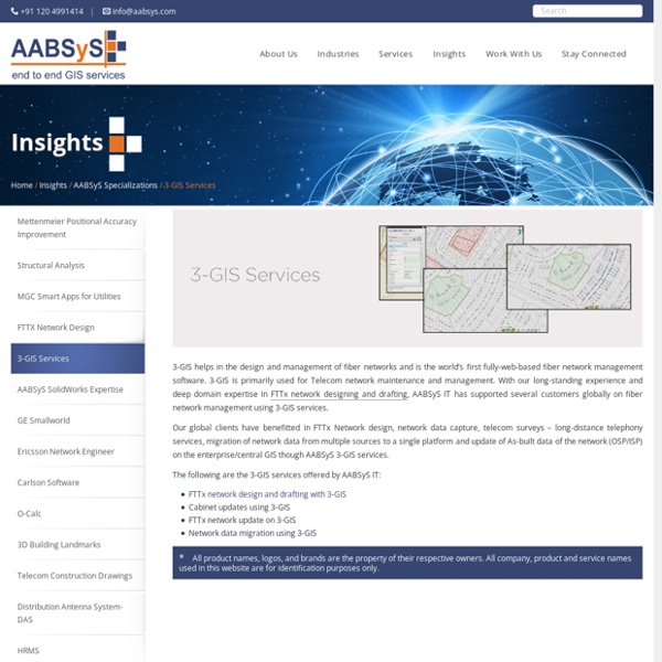
FTTX Network Design FTTx encompasses all possible optical fiber topologies from a telecom or cable carrier to customer premises based on the location of the termination point of the fiber connection. Increase in demand for subscriber bandwidth, increasing network cost pressure and the limits of copper technology has triggered the use of fiber in the access network. AABSyS IT has strong expertise and deep domain knowledge in FTTx network designing and drafting.
Topographic Mapping & 3D Topographic Maps at AABSyS Topographic mapping services helps in route planning, thematic data preparation, and decision-making for telecom and transport services and disaster management. The 3D topographic maps cover an area of approximately thousands of square kilometres and therefor require experienced expertise. AABSyS IT offers topographic mapping services to create comprehensive topographic maps and 3D topographic maps to the specified projection parameters, contours with ‘Z’ values, relief & planimetric details. AABSyS IT has successfully executed large-scale topographic mapping and 3D topographic mapping project.
Parcel Mapping Services & Land Parcel Maps at AABSyS Parcel Mapping is a process in which land parcels are created for efficient and effective land management. Parcel mapping service generates maps, created from base maps, with polygons that have details about the ownership of properties and other related information. The base maps used in parcel mapping are the cadastral maps showing each individual plots in different sub divisions. The land parcels are the fundamental data layer on which different data are referenced. Parcel mapping has a variety of uses such as land administration & property registration by urban and rural governing bodies.
Technology Services at AABSyS AABSyS focuses on end to end offerings in technology services. AABSyS pioneering efforts enable it to specially weave its solutions into customer environments. The company provides technology services that consistently meet or exceed customer’s expectations. These technology services are provided to various local, state, and federal government agencies; large companies and the private sector. AABSys provides product development and substance engineering thought its state of the art ISO 19001 Global offshore delivery center based out of Bhubaneswar, India.
GIS for Environmental Management at AABSyS The world is developing at an astonishing rate and while this development has aided in improving the quality of life, it has also escalated the unaccounted consumption of natural resources. GIS for Environmental Management acts as important management tool that helps in maintaining sustainability of natural resources, environment management. The environmental reforms and policies have grown leaps and bounds from the times of its foundation and therefore the use of modern technologies is inevitable.
GIS for Mining & Geology GIS at AABSyS The depletion of resources at a fast rate and implementation of policies that ensure sustainability of the resources have led mining and geology industry to realize the importance of technologies such as, GIS for mining and geology. While mining and geology industry is a traditional industry, the use of GIS for mining and geology has brought about a revolution by ensuring cost efficient and detailed studies of the concerned area. GIS for mining and geology helps in creation of maps that are an amalgamation of all the information regarding the concerned area. AABSyS GIS for mining and geology services use image analysis software packages such as ENVI, MultiSpec, ArcGIS, ERDAS Imagine / ER Mapper, MapInfo, AutoCAD Map and MicroStation to easily build focused and detailed spectral libraries tailored to the application requirements.
Software Resource Augmentation Services - Resource Augmentation & IT Outsourcing Services AABSyS IT has proven experience and expertise in providing software resource augmentation services for a wide spectrum of GIS technologies including ESRI, MapInfo, Autodesk, Intergraph, GeoServer, MapServer and other open source geospatial platforms. AABSyS resources have technical capabilities in providing services for software solutions ranging for desktop to large, scalable and secure web-enabled systems for enterprise and public portals. We provide highly experienced and skilled GIS software resources for building customized solutions or to assist the maintenance and support of the client’s existing applications. Our experience ranges from GIS software development, product development, and maintenance or product sustenance on both established and evolving emerging technologies. Notable features Advantages of Software Resource Augmentation Services