3d Walkthrough Animations at AABSyS
The housing and urban development industry utilise CAD and GIS services provided at AABSyS to generate 3D Models that are useful in study, design and planning of constructed space. The Architectural 3D modeling services are important feature for understanding a building’s architecture. They assist in easy visualization of the exteriors of a residential house, apartment, office, restaurant, and hotel. The Architectural 3D modeling helps AABSyS’s customers to visualize the property for better decision making for selling, leasing, or renting out a house or an office. They present a powerful overview of the actual architectural structure before or after its construction. The architectural floor plans with wall textures, colour schemes can be utilized for a better understanding of the exteriors of the building, house, office etc.
Survey GIS at AABSyS
Survey has played an important role in collecting data from areas that don’t have updated maps. Survey maps also play a crucial role in ground truthing the concerned area for creation of accurate land information maps. These maps also assists companies in understanding the market trends, land information for real estate, architecture, mining and utilities industries.
3d Walkthrough Animations at AABSyS
AABSyS creates customised 2D animations, 3D animations and 3D walkthroughs for the architecture and construction industry. A 3D walkthrough is the best solution to create a visual impact of an architectural structure. It depicts the interior and exterior landscapes of office buildings, residential complexes, and other visuals before the actual construction of the project. The 3D walkthrough animation can also be used in various forms such as presentation of client’s products and services in various media like television, websites, digital video commercials or innovative designs for print, DTP. 3D Exterior landscaping is created with proper placement of roads, vehicles, trees, fences, and other objects. The layout and designs of the rooms are arranged as per the customers plans provided.
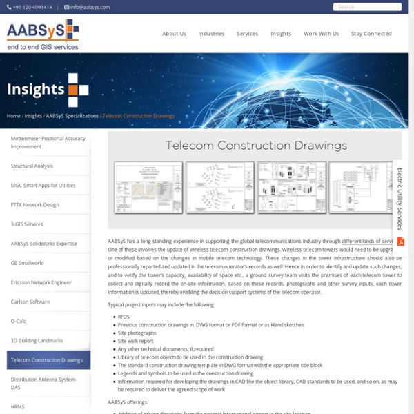
AutoCAD Drafting Services at AABSyS
AutoCAD Drafting services assist real estate developers, architects, engineers and contractors in creating a computerised version of the blue print, design, layout etc. They are easy to store, edit and share and therefore have become popular mode of data digitisation. The services offer high accuracy with no loss of data.
Solar Panel Layout Designs
Solar panels with photovoltaic power systems are designed to convert sunlight directly into electricity. A detailed solar panel layout plan is required for the construction and maintenance of large solar farms. With its rich experience in engineering design drafting, layout design along with expertise in template generation and standardization, AABSyS IT is well equipped to address the needs of the solar energy industry.
Municipal GIS Services for Municipality Tasks at AABSyS
AABSyS has been working with the local and national governmental organisations for a long time now and understands the uniqueness and confidentiality of governmental work. Many government aided bodies are recurring clients of AABSyS, as AABSyS provides a unique platform for generating timely and cost effective deliverables. The work involves GIS services such as georeferencing, satellite image processing, image classification, digitization, attribution, theme creation, map preparation, data analysis and report generation, computer aided designing and drafting services and remote sensing services.
Cadastral Mapping Services at AABSyS
Cadastral mapping is a comprehensive register of the details related to the property of an area. These details include the precise location, dimensions, and other geographical classifications of the properties or individual parcels of land. The maps generated using cadastral mapping services help in effective management of public land records. National and local governmental bodies, architecture and engineering firms, real estate developers, industries can uses the cadastral mapping services for making well informed decisions.
Architectural 3D CAD Modeling at AABSyS
The architectural team at AABSyS comprise of experts architects, engineers, draftsmen etc. They have vast experience and expertise to create 3D modeling of floor plans, convert the 2D floor plans into 3D floor plans and create a 3D model of the said houses or building complexes. The 3D architectural floor plans and 3D models can be augmented with AABSyS’s 3D services to provide a realistic view to the model. This model is created on any platform that is suitable to the client and is delivered after strict quality assurance procedures. AABSyS can create interior and exterior views of houses or other complexes using a customized 3D CAD modelling technique which can be used during building construction or renovation.
Topographic Mapping & 3D Topographic Maps at AABSyS
Topographic mapping services helps in route planning, thematic data preparation, and decision-making for telecom and transport services and disaster management. The 3D topographic maps cover an area of approximately thousands of square kilometres and therefor require experienced expertise. AABSyS IT offers topographic mapping services to create comprehensive topographic maps and 3D topographic maps to the specified projection parameters, contours with ‘Z’ values, relief & planimetric details. AABSyS IT has successfully executed large-scale topographic mapping and 3D topographic mapping project.