GIS for Water Distribution Network at AABSyS
Water industry requires the assistance of GIS in many verticals. The judicious use and conservation of water is one of the most talked about topics on global platforms. Every country tries to ensure optimisation of water use by using technologies such as GIS for water. Apart from its everyday use, water can be used for multiple purposes and therefore is an important part of the various industries. AABSyS extensive expertise and experience in carrying out projects of the Water Industry using its GIS for water services.
O-Calc
AABSyS IT has been successful through delivery of GIS and CAD services for a range of industries from utilities to design, civil engineering and architecture for the past several years. Together with our strategic partners, AABSyS has supported customers in Europe, Australia, US and India through a range of services including digitization, utility mapping, CAD plan re-drafting, survey plan conversion, PDF to CAD conversion, 2D to 3D model conversions, 3D building model rendering and generation of virtual walkthroughs. Our deep domain expertise in the utility industry also includes providing pole loading analysis and make-ready engineering services in the O-Calc platform.
GE Smallworld - AABSyS
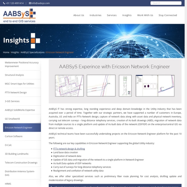
AABSyS IT has strong expertise, long standing experience and deep domain knowledge in the Utility industry that has been acquired over a period of time. Together with our strategic partners, we have supported a number of customers in Europe, Australia, US and India for projects on land base data creation, alignment of utility networks with land-base data, data migration from multiple sources to a single platform, network update based on As-Built drawings, Assets records management and GIS integration, etc. AABSyS technical teams have been successfully undertaking projects on the GE Smallworld GIS platform since 2006. AABSyS has significant project experience working on GE Smallworld GIS 4.0 and Smallworld GIS 4.3.
GIS for Business Geographics at AABSyS
A start-up venture or an established business often requires support in managing the large amounts of data. This data if utilised to its full potential can be immensely helpful in the growth of the company. With the modernisation and advancement in technology many tools such as GIS can help in accomplishing an array of tasks such as marketing, site selection, survey and data management. The spatial data management and analysis can help in better strategic marketing and management of any business vertical. Business geographics can assist in monitoring of the prelaunch and launch of a product by giving insights about market penetration, product reception and sale analysis.
2D Floor Plans of Houses and Offices
The housing and urban development industry utilise CAD and GIS services provided at AABSyS to generate floor plans that are useful in study, design and planning of constructed space. Architectural floor plans are important feature of any building’s sketch. They assist in easy visualization of the interior setup of a residential house, apartment, office, restaurant, and hotel.
GIS for Electricity Network Mapping at AABSyS
The fast pace of development and urbanisation has resulted in creation of new cities, townships etc. The new residential or commercial settlements require procurement of amenities such as well-planned out electricity lines that ensure smooth, hassle free transportation of electricity. The use of GIS for electricity has created much fervour in the utility industry. GIS for electricity, Remote Sensing, and CAD play an important role in designing, drafting, and planning of electricity supply lines within a township or from a power station in a time bound and organised manner. The maps of the concerned area are created use high end up-o-date software.
Architectural CAD Drafting Services at AABSyS
The architecture industry requires architectural CAD drafting services that create floor plans, furniture arrangements plans, elevations and cross-sectional views for residence and multi-stored building. These architectural CAD drafting services create deigns are generated from raster images or hand sketches. Computer aided designing involves creation of architectural CAD drafting designs. The architectural CAD drafting services play a crucial role in understanding space occupancy, forecast space needs and generating, stacking and blocking diagrams for space planning. The services replace manual drafting on paper and allows the designers to prepare drawings on computers. The application of architectural CAD drafting services have reduced the drafting efforts and increased the efficiency and quality considerably.
Architectural 3D CAD Modeling at AABSyS
The architectural team at AABSyS comprise of experts architects, engineers, draftsmen etc. They have vast experience and expertise to create 3D modeling of floor plans, convert the 2D floor plans into 3D floor plans and create a 3D model of the said houses or building complexes. The 3D architectural floor plans and 3D models can be augmented with AABSyS’s 3D services to provide a realistic view to the model. This model is created on any platform that is suitable to the client and is delivered after strict quality assurance procedures. AABSyS can create interior and exterior views of houses or other complexes using a customized 3D CAD modelling technique which can be used during building construction or renovation.
Utility Mapping Services & GIS mapping for Utilities - AABSYS
Utilities industries relies heavily on geographic information system, remote sensing utility mapping services, and computer aided design and drafting technologies for well-timed and cost effective functioning. AABSyS IT has extensive experience and expertise in the utility mapping services and field data capturing of utility networks such as electrical, water, gas, sewage & telecom. AABSyS IT offers utility conversion services for utility supply lines such as water mains, data lines, telephone lines, power lines, gas mains, and sewer lines. AABSyS IT’s utility mapping services help in efficient designing, resource management, outage and distribution management, database planning and installations management, power line management and monitoring. The utility mapping services also helps in documenting the vital underground and overhead assets digitally. AABSyS IT offers the following utility mapping service verticals: