
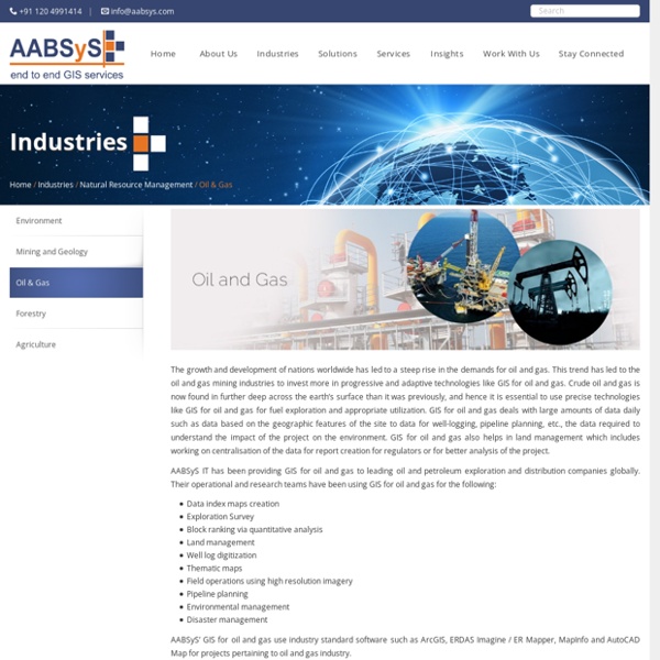
Utility Mapping Services & GIS mapping for Utilities - AABSYS Services for the Electric and Gas Utility Industry The global electric and gas utility industry relies heavily on geographic information system, remote sensing utility mapping services, and computer aided design and drafting technologies for their well-timed and cost effective functioning. AABSyS IT has extensive experience and expertise in the electric and gas utility mapping services and field data capturing of utility networks such as Electricity, Gas and Water. AABSyS electric and gas utility mapping services also helps in documenting the vital underground and overhead assets digitally. Key Services for Electric Utilities Key Services for Gas and Water Utilities Corridor Mapping New Connections Planning new lateral Lines Trouble Call Analysis Smart Application Development on Web, Android, and iOS platforms Click here to watch a quick video introduction to our Electric Utility Asset Data Management services Electric Utility Services
GIS for Electricity Network Mapping at AABSyS The fast pace of development and urbanisation has resulted in creation of new cities, townships etc. The new residential or commercial settlements require procurement of amenities such as well-planned out electricity lines that ensure smooth, hassle free transportation of electricity. The use of GIS for electricity has created much fervour in the utility industry. GIS for electricity, Remote Sensing, and CAD play an important role in designing, drafting, and planning of electricity supply lines within a township or from a power station in a time bound and organised manner. The maps of the concerned area are created use high end up-o-date software. The company works in multiple GIS for electricity and CAD formats and is therefore an ideally choice for clients worldwide. Network Mapping Network Re-Alignment Distribution Network Design AM/FM Mapping Consumer Indexing Network Topology Spatial Analysis Energy Auditing Network Analysis Pole Loading Analysis Solar Panel Layout Designs
Parcel Mapping Services & Land Parcel Maps at AABSyS Parcel Mapping is a process in which land parcels are created for efficient and effective land management. Parcel mapping service generates maps, created from base maps, with polygons that have details about the ownership of properties and other related information. The base maps used in parcel mapping are the cadastral maps showing each individual plots in different sub divisions. The land parcels are the fundamental data layer on which different data are referenced. Parcel mapping has a variety of uses such as land administration & property registration by urban and rural governing bodies. Municipality planning & urban development is taken care through the use of various parcel mapping techniques, which have the ability to restore analytical data that is crucial for enhancing the operational abilities of the government bodies. Municipal & other Urban Bodies Government Departments Builders Real Estate Agents Appraisers Engineers Surveyors Developers
Topographic Mapping | 3D Topographic Maps at AABSyS Topographic mapping services helps in route planning, thematic data preparation, and decision-making for telecom and transport services and disaster management. The 3D topographic maps cover an area of approximately thousands of square kilometres and therefor require experienced expertise. AABSyS IT offers topographic mapping services to create comprehensive topographic maps and 3D topographic maps to the specified projection parameters, contours with ‘Z’ values, relief & planimetric details. AABSyS IT has successfully executed large-scale topographic mapping and 3D topographic mapping project. The general steps involved in topographic mapping and 3D topographic mapping project are: Raster to Vector conversion of 3D topographic maps are conducted using high end, up-to-date CAD software such as AutoCAD, MicroStation etc.
Cadastral Mapping Services to create cadastral maps - AABSyS Cadastral mapping is a comprehensive register of the details related to the property of an area. These details include the precise location, dimensions, and other geographical classifications of the properties or individual parcels of land. The maps generated using cadastral mapping services help in effective management of public land records. National and local governmental bodies, architecture and engineering firms, real estate developers, industries can uses the cadastral mapping services for making well informed decisions. Cadastral mapping services also enable to user to study additional details, such as survey district names, unique identifying numbers for parcels, certificate of title numbers, positions of existing structures, section or lot numbers and their respective areas, adjoining street names, selected boundary dimensions and references to prior maps.
GE Smallworld - AABSyS AABSyS IT has strong expertise, long standing experience and deep domain knowledge in the Utility industry that has been acquired over a period of time. Together with our strategic partners, we have supported a number of customers in Europe, Australia, US and India for projects on land base data creation, alignment of utility networks with land-base data, data migration from multiple sources to a single platform, network update based on As-Built drawings, Assets records management and GIS integration, etc. AABSyS technical teams have been successfully undertaking projects on the GE Smallworld GIS platform since 2006. AABSyS has significant project experience working on GE Smallworld GIS 4.0 and Smallworld GIS 4.3. AABSyS has successfully delivered many projects in Electricity, Gas and Water network asset management systems in the European, American and Australian markets. * All product names, logos, and brands are the property of their respective owners.
GIS Application Development and Web GIS services - AABSyS AABSyS helps you in implementing enterprise GIS solutions to maintain up-to-date data, geo-spatial analysis and accurate modeling right from establishing requirement, specifying and designing the application, implementation to operating and maintaining in GIS application development life cycle. AABSyS provides end-to-end custom applications which are developed based on specific needs and requirements regardless of their complexity. We understand the customer requirements and provide a complete solutions suite to deliver the functionalities preferred. Our workflow consists of the modules like requirements analysis, design, coding, and deployment. We understand the problems from the grass-root levels to deliver the solution. Our broad range of services includes Map Customization, Custom Tool Development, Integration Application Migration, Web GIS, and Mobile GIS apps. development etc.
Municipal GIS Services | GIS for Municipality Tasks at AABSyS AABSyS has been working with the local and national governmental organisations for a long time now and understands the uniqueness and confidentiality of governmental work. Many government aided bodies are recurring clients of AABSyS, as AABSyS provides a unique platform for generating timely and cost effective deliverables. The work involves GIS services such as georeferencing, satellite image processing, image classification, digitization, attribution, theme creation, map preparation, data analysis and report generation, computer aided designing and drafting services and remote sensing services. The client’s requirements are paid utmost attention and the work is done in close co-ordination with the client. A municipal GIS system is a GIS system which manages various tasks of a municipality such as property tax, birth and death registration, socio economic data management and holding registration amongst other tasks. Need Municipal GIS Services?
AutoCAD Services | AutoCAD Drafting Services at AABSyS AutoCAD Drafting services assist real estate developers, architects, engineers and contractors in creating a computerised version of the blue print, design, layout etc. They are easy to store, edit and share and therefore have become popular mode of data digitisation. The services offer high accuracy with no loss of data. AutoCAD is one of the most common choice of platform of the customers worldwide for its easy, efficient and friendly tools. AABSyS offers the Auto CAD drafting services to real estate developers, architects, engineers and contractors all around the world. AABSyS can convert any original AEC Drawing into a perfectly accurate multi-layer AutoCAD drawing. Conversions including drafting services in different engineering fields, Creation of all type of as-built drawings for mechanical, electrical and plumbing sectors. Electric Utility Services