Topographic Mapping & 3D Topographic Maps at AABSyS
Topographic mapping services helps in route planning, thematic data preparation, and decision-making for telecom and transport services and disaster management. The 3D topographic maps cover an area of approximately thousands of square kilometres and therefor require experienced expertise. AABSyS IT offers topographic mapping services to create comprehensive topographic maps and 3D topographic maps to the specified projection parameters, contours with ‘Z’ values, relief & planimetric details. AABSyS IT has successfully executed large-scale topographic mapping and 3D topographic mapping project.
Forestry Mapping Services at AABSyS
Forestry mapping services such as Forestry GIS are often required by government and commercial agencies to perform value assessments for certification, funding, policy recommendations and regulatory compliances. Often, the forest-cover data available with the private and govt. agencies is dated and unreliable. This data is not helpful to the user, forestry GIS can enable creation of updated data.
Municipal GIS Services for Municipality Tasks at AABSyS
AABSyS has been working with the local and national governmental organisations for a long time now and understands the uniqueness and confidentiality of governmental work. Many government aided bodies are recurring clients of AABSyS, as AABSyS provides a unique platform for generating timely and cost effective deliverables. The work involves GIS services such as georeferencing, satellite image processing, image classification, digitization, attribution, theme creation, map preparation, data analysis and report generation, computer aided designing and drafting services and remote sensing services.
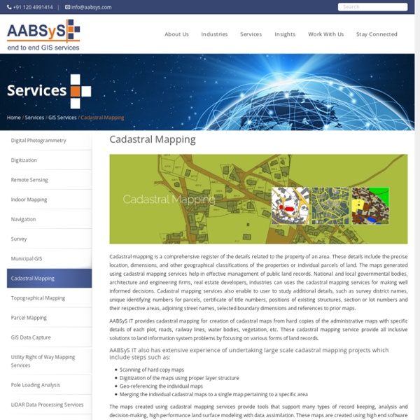
Parcel Mapping Services & Land Parcel Maps at AABSyS
Parcel Mapping is a process in which land parcels are created for efficient and effective land management. Parcel mapping service generates maps, created from base maps, with polygons that have details about the ownership of properties and other related information. The base maps used in parcel mapping are the cadastral maps showing each individual plots in different sub divisions. The land parcels are the fundamental data layer on which different data are referenced. Parcel mapping has a variety of uses such as land administration & property registration by urban and rural governing bodies.
GIS Application in Agriculture
GIS application in agriculture has been playing an increasingly important role in crop production throughout the world by helping farmers in increasing production, reducing costs, and managing their land resources more efficiently. GIS application in agriculture such as agricultural mapping plays a vital role in monitoring and management of soil and irrigation of any given farm land. GIS agriculture and agricultural mapping act as an essential tools for management of agricultural sector by acquiring and implementing the accurate information into a mapping environment. GIS application in agriculture also helps in management and control of agricultural resources. GIS agriculture technology helps in improvement of the present systems of acquiring and generating GIS agriculture and resources data. AABSyS IT uses GIS application in agriculture sector such as GIS agriculture for improving present method of acquiring and generating agricultural and resources data.
GIS for Environmental Management at AABSyS
The world is developing at an astonishing rate and while this development has aided in improving the quality of life, it has also escalated the unaccounted consumption of natural resources. GIS for Environmental Management acts as important management tool that helps in maintaining sustainability of natural resources, environment management. The environmental reforms and policies have grown leaps and bounds from the times of its foundation and therefore the use of modern technologies is inevitable.
GIS for Mining & Geology GIS at AABSyS
The depletion of resources at a fast rate and implementation of policies that ensure sustainability of the resources have led mining and geology industry to realize the importance of technologies such as, GIS for mining and geology. While mining and geology industry is a traditional industry, the use of GIS for mining and geology has brought about a revolution by ensuring cost efficient and detailed studies of the concerned area. GIS for mining and geology helps in creation of maps that are an amalgamation of all the information regarding the concerned area. AABSyS GIS for mining and geology services use image analysis software packages such as ENVI, MultiSpec, ArcGIS, ERDAS Imagine / ER Mapper, MapInfo, AutoCAD Map and MicroStation to easily build focused and detailed spectral libraries tailored to the application requirements.
GIS for Electricity Network Mapping at AABSyS
The fast pace of development and urbanisation has resulted in creation of new cities, townships etc. The new residential or commercial settlements require procurement of amenities such as well-planned out electricity lines that ensure smooth, hassle free transportation of electricity. The use of GIS for electricity has created much fervour in the utility industry. GIS for electricity, Remote Sensing, and CAD play an important role in designing, drafting, and planning of electricity supply lines within a township or from a power station in a time bound and organised manner. The maps of the concerned area are created use high end up-o-date software.
AutoCAD Drafting Services at AABSyS
AutoCAD Drafting services assist real estate developers, architects, engineers and contractors in creating a computerised version of the blue print, design, layout etc. They are easy to store, edit and share and therefore have become popular mode of data digitisation. The services offer high accuracy with no loss of data.
GIS for Oil and Gas at AABSyS
The growth and development of nations worldwide has led to a steep rise in the demands for oil and gas. This trend has led to the oil and gas mining industries to invest more in progressive and adaptive technologies like GIS for oil and gas. Crude oil and gas is now found in further deep across the earth’s surface than it was previously, and hence it is essential to use precise technologies like GIS for oil and gas for fuel exploration and appropriate utilization.