Cadastral Mapping Services at AABSyS
Cadastral mapping is a comprehensive register of the details related to the property of an area. These details include the precise location, dimensions, and other geographical classifications of the properties or individual parcels of land. The maps generated using cadastral mapping services help in effective management of public land records. National and local governmental bodies, architecture and engineering firms, real estate developers, industries can uses the cadastral mapping services for making well informed decisions. Cadastral mapping services also enable to user to study additional details, such as survey district names, unique identifying numbers for parcels, certificate of title numbers, positions of existing structures, section or lot numbers and their respective areas, adjoining street names, selected boundary dimensions and references to prior maps.
Forestry Mapping Services at AABSyS
Forestry mapping services such as Forestry GIS are often required by government and commercial agencies to perform value assessments for certification, funding, policy recommendations and regulatory compliances. Often, the forest-cover data available with the private and govt. agencies is dated and unreliable. This data is not helpful to the user, forestry GIS can enable creation of updated data. The fast paced growth and the effect of multiple industries have led to the need for a more precise and unique response to manage the forestry data. AABSyS IT’s forestry mapping services use Forestry GIS and other techniques to provide project specific solutions in the field of forest management, watershed management, desertification combat, biodiversity management, environmental monitoring and wildlife habitat encroachment.
Topographic Mapping & 3D Topographic Maps at AABSyS
Topographic mapping services helps in route planning, thematic data preparation, and decision-making for telecom and transport services and disaster management. The 3D topographic maps cover an area of approximately thousands of square kilometres and therefor require experienced expertise. AABSyS IT offers topographic mapping services to create comprehensive topographic maps and 3D topographic maps to the specified projection parameters, contours with ‘Z’ values, relief & planimetric details. AABSyS IT has successfully executed large-scale topographic mapping and 3D topographic mapping project. The general steps involved in topographic mapping and 3D topographic mapping project are: Raster to Vector conversion of 3D topographic maps are conducted using high end, up-to-date CAD software such as AutoCAD, MicroStation etc.
Parcel Mapping Services & Land Parcel Maps at AABSyS
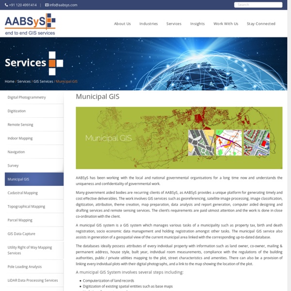
Parcel Mapping is a process in which land parcels are created for efficient and effective land management. Parcel mapping service generates maps, created from base maps, with polygons that have details about the ownership of properties and other related information. The base maps used in parcel mapping are the cadastral maps showing each individual plots in different sub divisions.
GIS Application in Agriculture
GIS application in agriculture has been playing an increasingly important role in crop production throughout the world by helping farmers in increasing production, reducing costs, and managing their land resources more efficiently. GIS application in agriculture such as agricultural mapping plays a vital role in monitoring and management of soil and irrigation of any given farm land. GIS agriculture and agricultural mapping act as an essential tools for management of agricultural sector by acquiring and implementing the accurate information into a mapping environment. GIS application in agriculture also helps in management and control of agricultural resources.
GIS for Environmental Management at AABSyS
The world is developing at an astonishing rate and while this development has aided in improving the quality of life, it has also escalated the unaccounted consumption of natural resources. GIS for Environmental Management acts as important management tool that helps in maintaining sustainability of natural resources, environment management. The environmental reforms and policies have grown leaps and bounds from the times of its foundation and therefore the use of modern technologies is inevitable. Modern day technologies like GIS for Environmental Management can help in understanding the effects on the environment from an inter-disciplinary aspect. This holistic approach is not only benefits the flora and fauna but also benefits mankind by achieving sustainable development using GIS for Environmental Management.
GIS for Mining & Geology GIS at AABSyS
The depletion of resources at a fast rate and implementation of policies that ensure sustainability of the resources have led mining and geology industry to realize the importance of technologies such as, GIS for mining and geology. While mining and geology industry is a traditional industry, the use of GIS for mining and geology has brought about a revolution by ensuring cost efficient and detailed studies of the concerned area. GIS for mining and geology helps in creation of maps that are an amalgamation of all the information regarding the concerned area.
GIS for Electricity Network Mapping at AABSyS
The fast pace of development and urbanisation has resulted in creation of new cities, townships etc. The new residential or commercial settlements require procurement of amenities such as well-planned out electricity lines that ensure smooth, hassle free transportation of electricity. The use of GIS for electricity has created much fervour in the utility industry.
AutoCAD Drafting Services at AABSyS
AutoCAD Drafting services assist real estate developers, architects, engineers and contractors in creating a computerised version of the blue print, design, layout etc. They are easy to store, edit and share and therefore have become popular mode of data digitisation. The services offer high accuracy with no loss of data. AutoCAD is one of the most common choice of platform of the customers worldwide for its easy, efficient and friendly tools. AutoCAD has the import and export facility to all other advanced and high-end software in the field of CAD and GIS.
GIS for Oil and Gas at AABSyS
The growth and development of nations worldwide has led to a steep rise in the demands for oil and gas. This trend has led to the oil and gas mining industries to invest more in progressive and adaptive technologies like GIS for oil and gas. Crude oil and gas is now found in further deep across the earth’s surface than it was previously, and hence it is essential to use precise technologies like GIS for oil and gas for fuel exploration and appropriate utilization. GIS for oil and gas deals with large amounts of data daily such as data based on the geographic features of the site to data for well-logging, pipeline planning, etc., the data required to understand the impact of the project on the environment. GIS for oil and gas also helps in land management which includes working on centralisation of the data for report creation for regulators or for better analysis of the project.
GIS for Telecommunication
Requirement The customer, a leading Telecom Companies based in Middle-East Asia required AABSyS to provide assetization of a large Telecom Network project in the Middle-East. The main scope of the project included, capturing of conduit network, semi duct fiber network, direct buried cable and aerial cable. It also included the capturing of cross-sections for conduits and ducts.