AutoCAD Drafting Services at AABSyS
AutoCAD Drafting services assist real estate developers, architects, engineers and contractors in creating a computerised version of the blue print, design, layout etc. They are easy to store, edit and share and therefore have become popular mode of data digitisation. The services offer high accuracy with no loss of data. AutoCAD is one of the most common choice of platform of the customers worldwide for its easy, efficient and friendly tools. AutoCAD has the import and export facility to all other advanced and high-end software in the field of CAD and GIS.
Forestry Mapping Services at AABSyS
Forestry mapping services such as Forestry GIS are often required by government and commercial agencies to perform value assessments for certification, funding, policy recommendations and regulatory compliances. Often, the forest-cover data available with the private and govt. agencies is dated and unreliable. This data is not helpful to the user, forestry GIS can enable creation of updated data. The fast paced growth and the effect of multiple industries have led to the need for a more precise and unique response to manage the forestry data. AABSyS IT’s forestry mapping services use Forestry GIS and other techniques to provide project specific solutions in the field of forest management, watershed management, desertification combat, biodiversity management, environmental monitoring and wildlife habitat encroachment.
3d Walkthrough Animations at AABSyS
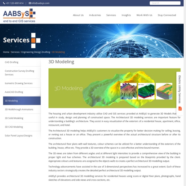
AABSyS creates customised 2D animations, 3D animations and 3D walkthroughs for the architecture and construction industry. A 3D walkthrough is the best solution to create a visual impact of an architectural structure. It depicts the interior and exterior landscapes of office buildings, residential complexes, and other visuals before the actual construction of the project. The 3D walkthrough animation can also be used in various forms such as presentation of client’s products and services in various media like television, websites, digital video commercials or innovative designs for print, DTP.
GIS for Municipality Tasks at AABSyS
AABSyS has been working with the local and national governmental organisations for a long time now and understands the uniqueness and confidentiality of governmental work. Many government aided bodies are recurring clients of AABSyS, as AABSyS provides a unique platform for generating timely and cost effective deliverables. The work involves GIS services such as georeferencing, satellite image processing, image classification, digitization, attribution, theme creation, map preparation, data analysis and report generation, computer aided designing and drafting services and remote sensing services. The client’s requirements are paid utmost attention and the work is done in close co-ordination with the client. A municipal GIS system is a GIS system which manages various tasks of a municipality such as property tax, birth and death registration, socio economic data management and holding registration amongst other tasks.
GIS Application in Agriculture
GIS application in agriculture has been playing an increasingly important role in crop production throughout the world by helping farmers in increasing production, reducing costs, and managing their land resources more efficiently. GIS application in agriculture such as agricultural mapping plays a vital role in monitoring and management of soil and irrigation of any given farm land. GIS agriculture and agricultural mapping act as an essential tools for management of agricultural sector by acquiring and implementing the accurate information into a mapping environment. GIS application in agriculture also helps in management and control of agricultural resources.
Cadastral Mapping Services at AABSyS
Cadastral mapping is a comprehensive register of the details related to the property of an area. These details include the precise location, dimensions, and other geographical classifications of the properties or individual parcels of land. The maps generated using cadastral mapping services help in effective management of public land records. National and local governmental bodies, architecture and engineering firms, real estate developers, industries can uses the cadastral mapping services for making well informed decisions. Cadastral mapping services also enable to user to study additional details, such as survey district names, unique identifying numbers for parcels, certificate of title numbers, positions of existing structures, section or lot numbers and their respective areas, adjoining street names, selected boundary dimensions and references to prior maps.
Topographic Mapping & 3D Topographic Maps at AABSyS
Topographic mapping services helps in route planning, thematic data preparation, and decision-making for telecom and transport services and disaster management. The 3D topographic maps cover an area of approximately thousands of square kilometres and therefor require experienced expertise. AABSyS IT offers topographic mapping services to create comprehensive topographic maps and 3D topographic maps to the specified projection parameters, contours with ‘Z’ values, relief & planimetric details. AABSyS IT has successfully executed large-scale topographic mapping and 3D topographic mapping project. The general steps involved in topographic mapping and 3D topographic mapping project are: Raster to Vector conversion of 3D topographic maps are conducted using high end, up-to-date CAD software such as AutoCAD, MicroStation etc.
GIS for Electricity Network Mapping at AABSyS
The fast pace of development and urbanisation has resulted in creation of new cities, townships etc. The new residential or commercial settlements require procurement of amenities such as well-planned out electricity lines that ensure smooth, hassle free transportation of electricity. The use of GIS for electricity has created much fervour in the utility industry.