
Google Maps API v3 with Custom Pins Google Maps API offers a wide variety of applications that enable you to embed the functionality and customisation of Google Maps into an external website at no cost. This tutorial aims to guide you through the process of embedding a basic map, located at a specific point with a custom pin, which can be particularly useful for ‘contact’ pages. Step 1 – Setup jQuery and Google MAP API Mommy Maestra: Día de los Muertos, Day of the Dead Lesson Plans and Activities Día de los Muertos is quickly approaching, so I thought I would share some of the many fabulous resources that I have discovered over the years. Because this holiday is so popular, there is a growing number of lesson plans, units, and crafts now available on-line. Thematic Units: - By far, one of the best curriculum units has been created by Lori Langer de Ramirez, creator of MisCositas. It is geared for third year (intermediate) Spanish students. This is a comprehensive unit with 63 pages of activities, vocabulary, and more.
Maps Screen reader users: click here for plain HTML +You Search Images Userful - Wikipedia, the free encyclopedia-Mozilla Firefox Userful is a desktop virtualization company that focuses on simple, cross platform and low cost VDI solutions for education, public computing, SMBs and digital signage. The company develops software to install on even a standard Core i7 PC to create mulitple virtual desktops including a choice of Microsoft Windows, cloud-client, Linux and remote desktop protocols like VMWare and Citrix. The company’s approach is similar to thin clients but uses ultra-thin or zero clients to deliver visibly better streaming video and audio performance at lower costs.[1] Userful, based in Calgary, Alberta is a privately held for-profit company with resellers.[2] In February 2014, Userful launched Userful Multiplatform 7.0 that provides high performance and low cost to bring desktop virtualization beyond desktops to any endpoint. [3]
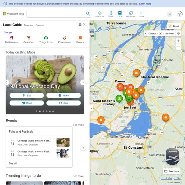
The New Bing Maps Is Now Live: We Take It For A Test Drive Earlier this morning Microsoft outlined some of the major new changes coming to Bing, including the introduction of the new Bing Maps (you can see our full coverage here). A few minutes ago, the Bing Maps Beta went live for everyone, bringing with it a number of innovative new features sure to keep the Google Maps team on their toes. You can try out the new beta here. But there’s one catch: in order to tap into the site’s new features, you’re going to have to have Microsoft’s Silverlight installed. There are a number of new things to check out here. First, there’s Streetside, Bing’s answer to Google Street View. NAVTEQ HERE.Maps for Life. You know us as NAVTEQ Maps. Now we’re pleased to introduce HERE- our new brand for the best map in the world. HERE map updatesfor your navigation system Keep your life on track with the most up-to-date maps on navigation.com
MapMaker Interactive YouTube Help The URL to a YouTube video must be the full length url. To ensure you are using the correct URL, visit your video on youtube.com. The URL to your video will be in your browser's address (see photo for an example) My Nero Dear My Nero Forum user, with the launch of our new products Nero 2014 Platinum and Nero 2014 we also have introduced a new Nero Forum. Effective Sept 30th, the My Nero Forum will be deactivated and set to "read-only".No new posts or comments can be created anymore after this date. Nero wants to thank all My Nero Forum users for their participation over the last years and invites everyone to join our new Nero Forum:
XBee Helps Libelium Monitor Harsh Environments - Digi International-Mozilla Firefox Background Sensor technology research and development is important for monitoring the environment around us, ranging from prevention of forest fires and floods to detecting and monitoring contamination levels in cities. The research and development team at Libelium (Zaragoza, Spain) is dedicated to developing hardware for the implementation of wireless sensor networks, mesh networks and communication protocols. Libelium needed radio frequency modules to guarantee accurate transmission of information from sensors placed in isolated or difficult-to-access areas. To enable Libelium to develop its sensor devices, they needed to source a wireless networking provider that offered both long-range links and the interconnection of wireless networks of different frequencies. “Our objective is to detect and store critical values and send these values to a data processing centre for analysis or send emergency alarms. Take the agricultural industry as an example.
Augmented-reality maps: Blaise Aguera y Arcas on TED Live from TEDGlobal 2013 If you sped up the scene at the Edinburgh International Conference Centre today, it would look like blurs of red and green streaks — the red from the TED logos on the T-shirts of the crew who are busily setting up for TEDGlobal 2013, and the green from the name badges worn by staff members […] Since the Talk Exclusive demo: Blaise Agüera y Arcas shows how the new Photosynth lets you swoop through 3D space List of OSM based Services Available languages — Alphabetically sorted complete list of projects using especially data from OpenStreetMap. For any page using just the OSM Map see OSM Internet Links. For smaller user favourites lists see: The term free materials is what you would colloquially refer to as "open".