
Floodplain Modeling To start, you may want to watch the What is Engineering video. What is Engineering Too much rainfall or melting snow can sometimes cause a flood. There are different types of floods. Floods can be deadly and destructive to people and property. You can introduce the activity by showing students the PowerPoint presentation, Floods, Floodplains and Levees, to provide a visual understanding of floods, floodplains and levees. Floods, Floodplains and Levees (PPT) Students will learn more about flooding by creating their own mini-floods. In this lesson, students act as engineers, buildingmini-houses (models) and determining if they get wiped out by the flood. Students will test a few different situations that cause flooding. Asking Good Questions There are a few considerations.
Interactive - Rock Back in Time | Interactives The Minerals Council of Australia is acknowledged as the provider of this resource. In this learning object, users choose a rock sample and find out how it was formed millions of years ago. For example, how coal was formed in a swampy forest. Explore the Earth’s surface at the time when the rock formed. Look at maps, landscapes, living things and environments. Compare temperatures and sea levels with those of today. Educational value statement Key learning objectives Students explore changes in the Australian landmass, environments and living things over the last 545 million years.Students compare climatic conditions and sea levels over geological time.Students relate geological changes in the Earth’s surface to plate tectonics.Students identify major periods in the geological time scale. Strands Science/Natural and processed materialsScience/Science inquiry skillsScience/Science understanding. Australian Curriculum content statements (explicit)Science: ACSSU153; [ACSIS144]
Fossil Fuels Fossil fuels: Energy from fossilised organic materials Custom Search How it works: Coal is crushed to a fine dust and burnt. Oil and gas can be burnt directly. The main bit to remember: More: More details on 'clean coal technology' from BBC News web site... Other fossil fuels are being investigated, such as bituminous sands and oil shale. As far as we know, there is still a lot of oil in the ground. Find out more at www.eia.doe.gov/emeu/cabs/canada.html Disadvantages Basically, the main drawback of fossil fuels is pollution.
seiche Mysterious donation for Broken Hill art gallery Margaret Paul Posted Thu 14 Mar 2013, 7:29am AEDT The Broken Hill Regional Art Gallery has a mysterious overseas benefactor. The gallery has received several boxes of books about Japanese art that are postmarked from Japan. Manager Cathy Farry says the pictures are nice to look at and the books are publicly available if anyone wants to have a look. But she says she does not know who they are from. "We keep them safe and look after them," she said. "They just appeared so I don't even know where they're from because I can't read the Japanese." Staff at the gallery have been busy moving all the books in the library to another room in the gallery so the library can be turned into an exhibition space. Ms Farry says the new exhibition space is now open, and features works done at a recent screen-printing workshop. "They're really varied in the styles," she said. "Some have an almost folk-art appearance, and others are a bit more expressive, I suppose, free-styling a bit more."
Interactive Animations This is our collection of interactive rollover flash animations. Click links or scroll down to view the available interactive animations.Check out our Earth Science Animations and Videos pages. Interactive Animations General Basin and Range Dynamic Planet- Earthquakes & Volcanoes Tectonics How Are Earthquakes Located- Walk Run Activity Earthquakes Tectonic Plates Volcanoes Significant Earthquakes from 2001-2011 NEW! Pacific Northwest Pacific Northwest vs Japan Pacific Northwest vs Sumatra Subduction Zones Northwest Plate Rollover Chile vs Sumatra Subduction Rollover Reveal Pacific Northwest vs Sumatra Earthquake Depth Rollover Pacific Northwest vs Japan Earthquake Rollover Volcanoes Rollover General Significant Earthquakes from 2001-2011 Download interactive Flash animation. Dynamic Planet- Earthquakes & Volcanoes Download interactive Flash animation. How Are Earthquakes Located- Walk Run Activity Download IRIS one-pager, "How are earthquakes located?" Tectonic Plates Basin and Range Tectonics Earthquakes
Contour Education Fossil fuels Fuels such as coal, oil and natural gas were formed over millions of years from organic matter like plankton, plants and other life forms. Over time, sand, sediment and rock buried the organic matter and it eventually formed large quantities of fuels. These underground resources, known as fossil fuels, are still the primary fuel source for electricity, heating and powering vehicles around the globe. Five main fossil fuels Coal is a combustible black or brown organic sedimentary rock. It’s mostly carbon and is typically found as layers (coal beds) or veins (coal seams). Natural gas is a combustible mix of hydrocarbon gases. Oil is mostly known as crude oil or condensate, but includes all liquid hydrocarbon fossil fuels. Petroleum is a liquid fuel made of hydrocarbons and other liquid organic compounds. Liquefied petroleum gas or LPG is heavier than natural gas. Inside a gas plant: fast, flexible fuel Ever wondered how gas is converted into electricity for your home? Source: Origin Energy
engineering Surveying, cadastral surveying, laser surveying, hydrographic surveying, mining surveying, land surveying | A Life Without Limits There are many specialisations within Surveying you can choose from, depending on your interests and whether you want to work in the city, country or coastal areas. Land Surveying Land (Cadastral) Surveyors determine and advise on property boundaries when land is subdivided, bought or sold. Engineering New freeway systems, bridges and high-rise buildings all need precise planning. Mining Mining Surveyors design and measure mines, tunnels and other underground works. Hydrographic Hydrographic Surveyors map the sea floor and other waterways. Environmental Projects Surveyors are integral to sustainable development and environmental projects as they measure the change in geographic information. Geodesy Geodesy is a science of the measurement and mapping of the earth’s surfaces. Topographic Topographic Surveyors measure elevation points on land and the environment. Remote Sensing Geographic information systems are used widely for planning decisions. Archaeology Forensics
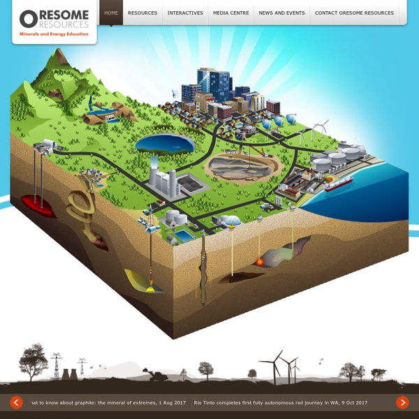
Minerals Geoscience Australia provides pre-competitive geoscience information to address greenfield exploration challenges and identify new mineral provinces within Australia. This pre-competitive information is acquired through integrated programs of national strategic importance, such as the Unlocking Australia's Hidden Mineral Resource Potential Program which commenced in July 2013. The Agency also advises the Australian Government on mineral resources, mining and land use which is integral to decisions on the nation's known mineral endowment, the sustainable development of mineral resources and levels of exploration activity. Mineral Resources Details of the economics and reporting of Australia's mineral resources including the annual publication Australia's Identified Mineral Resources. Minerals - DisciplinesInformation on disciplines and techniques including geochemistry, geochronology, geophysics and spectral geology.
The Southeastern Suture of the Appalachian Margin Experiment (SESAME) The super-continent Gondwana attached to proto-North America at the culmination of the continental collision that built the Appalachian Mountains about 300 million years ago. Based on variations in fossils, rock types and ages, and a zone of southward dipping reflectors imaged by seismic reflection data, the juncture between these two continents is thought to lie in the crust beneath southern Georgia. Subsequently, this region was rifted during the opening of the Atlantic Ocean, depositing large volumes of magma into the crust. The goal of the SESAME project is to better understand how the continental lithosphere was accreted and deformed during collision and how rifting and formation of the current Atlantic passive margin later modified it. To investigate these fundamental questions, 85 EarthScope Flexible Array stations were deployed in two north-to-south lines that cross the suture zone. Field Dates: July 2010 - June 2014 (in progress)
Teacher Earth Science Education Programme - TESEP: Home page Unburnable carbon 2013: Wasted capital and stranded assets This new research from Carbon Tracker and the Grantham Research Institute on Climate Change and the Environment at LSE calls for regulators, governments and investors to re-evaluate energy business models against carbon budgets, to prevent $6trillion carbon bubble in the next decade. Unburnable carbon 2013: Wasted capital and stranded assets has revealed that fossil fuel reserves already far exceed the carbon budget to avoid global warming of 2°C, but in spite of this, spent $674billion last year to find and develop new potentially stranded assets. “Smart investors can see that investing in companies that rely solely or heavily on constantly replenishing reserves of fossil fuels is becoming a very risky decision. The carbon budget deficit Between 60-80% of coal, oil and gas reserves of publicly listed companies are ‘unburnable’ if the world is to have a chance of not exceeding global warming of 2°C (click image for larger version of the diagram) Stranded assets Wasted capital Recommendations
sis_cube_about About the implementation of CUBE in SIS The CUBE (Combined Uncertainty and Bathymetry Estimator) algorithm is developed at The Centre for Coastal and Ocean Mapping (C-COM)/Joint Hydrographic Centre (JHC) at University of New Hampshire. The algorithm is available as a library and is used inside one separate module in SIS. The CUBE algorithm can be used as an alternative data gridding and data cleaning method in SIS. The gridding and data cleaning is a default process done by the GridEngine. Cube is not available when logging data. The CUBE module in SIS receives ping data on UDP where depth and angle gate are applied to the data. The GridEngine holds both a processing grid and a display grid. The implementation of LOD in the GridEngine also results in less sensitivity to the grid cell size when displaying grids - see the next four figures. SIS must chose between either GridEngine or CUBE grids. CUBE also need some amount of data density to do the gridding.