
Creating Contour Maps « this is onformative a studio for generative design. Creating Contour MapsCreating 3d contour maps using heightmaps in processing.
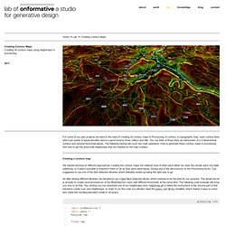
For some of our past projects we were in the need of creating 3d contour maps in Processing. A contour, or topographic map, uses contour lines which join points of equal elevation above a given level to show valleys and hills. You can think of these lines as intersection of a 3-dimensional surface and several horizontal planes. The following tutorial will cover two main questions. How to generate these contour maps in processing.