Windows Explorer in C# For creating a Windows Explorer type of application we need to design our form in the following manner.
Follow the following steps. Now we'll start with the coding part of our project. The first thing is to determine that a particular computer has how many drives so instead of determining it manually we can always make use of DriveInfo class which is there in System.IO namespace it can help you to get all the drives which are currently present in one PC. So there is no need to create a separate program for every PC. Before doing this we need to create some Treenodes at the class level for Desktop, My Documents and My Computer.The Code for the following is: drivenode.ImageIndex = 5; break;case DriveType.Network:drivenode.ImageIndex = 1;break;case DriveType.Unknown:drivenode.ImageIndex = 2; break;}getFilesAndDir(drivenode, dir);}}The above code will create all drives which are present in the current computer and it will add it under the comp nodes which has been created at the class level.
Proj.Net <> GDAL ? Proj.Net - Documentation. SharpMap - Geospatial Application Framework for the CLR - Download: SharpMap 1.1. This is a binary release of the SharpMap 1.1.
Please use it and report any issues found either by submitting a bug report or by leaving a comment on the forum. We will try to assist all of you if you have problems migrating You can get (almost) the same using NuGet ( New Features OleDbTwoPoint providerReprojection of GdalRasterLayerHeatLayerNew Property MapScale that can get/set the current Scale of the mapNew Provider: OracleSpatialProvider that uses ODP.NET and ODAC to access OracleSpatial tables in a more efficient way and improve performanceGDALTileIndexRasterLayer to be able to use TileIndex-shapefiles created by gdaltindex.exe to draw mosaics of rasters in an efficient wayGdiImageLayer with (optional) use of a world file Bug fixes. GDAL .img to ASCII. Hi Alexis, You can do this using GDAL.
If you are not familiar with it, GDAL is a general geospatial tool that can read, manipulate, and export geospatial data. Reprojecting a shapefile with GDAL/OGR and Python. I needed to reproject shapefiles -- unprojected lat/long WGS84 -- and once again the page Geoprocessing with Python using Open Source GIS was of great help, so the credit goes to this page, which is very worthwhile studying as an introduction to using gdal/ogr and Python.
The code below is an adjustment of homework 2b in the page above for my case. I tried to add explanations to the original code so that it's easy to follow by just reading it -- hope I'm right.... The unprojected file: GDAL Wrapper for .NET and Mono - Home. Shapefile - API documentation for Gdal/Ogr with C# Current community your communities Sign up or log in to customize your list. more stack exchange communities Stack Exchange sign up log in tour help Geographic Information Systems Ask Question Take the 2-minute tour × Geographic Information Systems Stack Exchange is a question and answer site for cartographers, geographers and GIS professionals.
API documentation for Gdal/Ogr with C# 2 Answers active oldest votes Your Answer Sign up or log in Sign up using Google Sign up using Facebook Sign up using Stack Exchange Post as a guest discard By posting your answer, you agree to the privacy policy and terms of service. Not the answer you're looking for? Related Deploying Application With C# GDAL/OGR Bindings installing GEOS, PROJ, GDAL/OGR into a python virtualenv on Mac OS X. Getting started with C# and GDAL. GDAL API Tutorial. Before opening a GDAL supported raster datastore it is necessary to register drivers.
There is a driver for each supported format. Normally this is accomplished with the GDALAllRegister() function which attempts to register all known drivers, including those auto-loaded from .so files using GDALDriverManager::AutoLoadDrivers(). GDAL LIB csharp. GDAL can be built on Win32 platforms using MS VC++ 6.x and MS Visual Studio .NET (C++).
The source distribution includes NMAKE compatible makefiles for use from the command shell. For those wanting Visual Studio 7.1 or 8.0 Solution files (instead of the command line nmake files), Ben Discoe normally makes them available on the VTP site. Megdr to voxel ( github ) rachel carvalho. Voxel Mars. HiView: Image Viewer. What HiView Does HiView is the best way to explore HiRISE images of the Martian surface at the full resolution of the imagery.
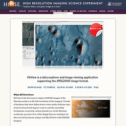
Tracks of boulders that have fallen down crater walls, delicate rays of ejecta from fresh impact craters, and the unearthly formations created by carbon dioxide ice on the Martian south pole are just a few of the things that are waiting to be discovered by anyone using a tool like HiView with HiRISE imagery. Once the application has been downloaded to your computer, all that is needed to get started after launching the application, is a quick drag and drop of any of the links to the JP2 files on the HiRISE website to the HiView application window, and HiView will take care of the rest. No downloading of multigigabyte files required! Whether you are just interested in exploring HiRISE images, or a scientist wanting to get valuable information from an observation, HiView is a versatile and powerful application. Powerful tools Note: Install software at your own risk. GtkSharpTutorials.