
List of metropolitan areas in the European Union by GDP. A metropolitan region's gross domestic product, or GDP, is one of several measures of the size of its economy.
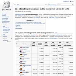
Similar to GDP, GRP is defined as the market value of all final goods and services produced within a metropolitan area in a given period of time. In this case the statistics of Eurostat's[1] Urban Audit for Larger Urban Zones have been used. List of gross domestic products in EU metropolitan areas[edit] The table below shows data from Eurostat's Urban Audit program and participating Larger Urban Zones (LUZs).
Nationally established and/or recognized metropolitan areas may take preference, if equivalent to correspondingly joined Larger Urban Areas. List of Gross Domestic Products in EU cities/agglomeration areas[edit] A 2008 survey by PricewaterhouseCoopers uses mainly US$ data by OECD, but is based on city boundaries. Location of European Union institutions. The seats have been a matter of political dispute since the states first failed to reach an agreement at the establishment of the European Coal and Steel Community in 1952.
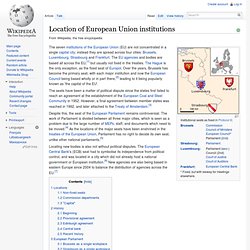
However, a final agreement between member states was reached in 1992, and later attached to the Treaty of Amsterdam.[3] Despite this, the seat of the European Parliament remains controversial. The work of Parliament is divided between all three major cities, which is seen as a problem due to the large number of MEPs, staff, and documents which need to be moved.[4] As the locations of the major seats have been enshrined in the treaties of the European Union, Parliament has no right to decide its own seat, unlike other national parliaments.[5] Locating new bodies is also not without political disputes.
Flemish Diamond. A map of the Flemish Diamond within Belgium.
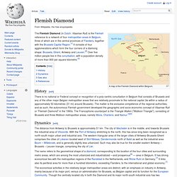
The Flemish Diamond (in Dutch: Vlaamse Ruit) is the Flemish reference to a network of four metropolitan areas in Belgium, three of which are in the central provinces of Flanders, together with the Brussels Capital Region.[1] It consists of four agglomerations which form the four corners of a diamong shape: Brussels, Ghent, Antwerp and Leuven.[2] Over five million people live in this conurbation, with a population density of more than 800 per square kilometre.[3] History[edit] Dynamics[edit] The distance from Antwerp to Brussels is approximately 51 km.
The city of Mechelen is in the middle, and towards Brussels the industrial area of Vilvoorde. The name refers to the geometrical shape of a diamond, corresponding to the location of the four cities and surrounding metro areas, which are among the most urbanized and industrialized —and prosperous[6] — area in Belgium. See also[edit] References[edit] General sources: Vanhaverbeke, Wim (January 1997). Golden Banana. The Golden Banana The Golden Banana or "sun belt" is a term used by analysts when discussing urbanisation in a European context.
It denotes an area of higher population density lying between Valencia in the west and Genoa in the east along the coast of the Mediterranean Sea, defined by the "Europe 2000" report from the European Commission in 1995 to be analogous to the so-called Blue Banana. The region is a centre for information technology and manufacturing.[1][2] See also[edit] Flemish Diamond. Blue Banana. The Blue Banana The Blue Banana (also known as the Hot Banana, Bluemerang, European Megalopolis, Manchester-Milan Axis or European Backbone) is a discontinuous corridor of urbanisation in Western Europe, with a population of around 110 million.[1] It stretches approximately from North West England in the north to Milan in the south.
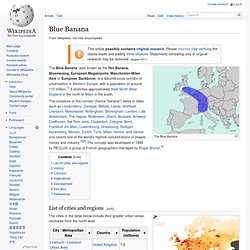
List of cities and regions[edit] Population density in Europe, showing the highest density along the Blue Banana. Population density worldwide. The cities in the table below include their greater urban areas, clockwise from the north-west. History[edit] The French geographer Roger Brunet, who wished to subdivide Europe into “active” and “passive” spaces, developed the concept of a West European “backbone” in 1989. He saw the Blue Banana as the development of historical precedents, e. g. known trade routes, or as the consequence of the accumulation of industrial capital.