
3D Driving Simulator on Google Maps. Matherix Labs. Kinect-carrying drone automatically builds 3D maps of rooms. Google Street View eat your heart out: An MIT-built quadrocopter uses Microsoft Kinect, and some smart odometry algorithms, to fly around a room and spit out a 3D map of the environment.
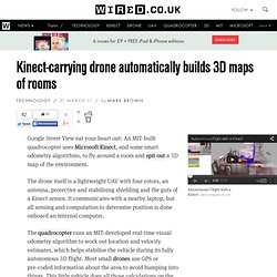
The drone itself is a lightweight UAV with four rotors, an antenna, protective and stabilising shielding and the guts of a Kinect sensor. It communicates with a nearby laptop, but all sensing and computation to determine position is done onboard an internal computer. The quadrocopter runs an MIT-developed real-time visual odometry algorithm to work out location and velocity estimates, which helps stabilise the vehicle during its fully autonomous 3D flight.
Most small drones use GPS or pre-coded information about the area to avoid bumping into things.