
United States. The United States of America (USA), commonly referred to as the United States (US), America or simply the States, is a federal republic[10][11] consisting of 50 states and a federal district. The 48 contiguous states and the federal district of Washington, D.C., are in central North America between Canada and Mexico. The state of Alaska is the northwestern part of North America and the state of Hawaii is an archipelago in the mid-Pacific.
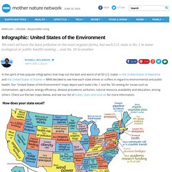
Infographic: United States of the Environment. In the spirit of two popular infographics that map out the best and worst of all 50 U.S. states — the United States of Awesome and the United States of Shame — MNN decided to see how each state shines or suffers in regard to environmental and public health.

Our "United States of the Environment" maps depict each state's No. 1 and No. 50 ranking for issues such as conservation, agriculture, energy efficiency, disease prevalence, pollution, natural resource availability and education, among others. Check out the two maps below, and see our list of states, stats and sources for more information.
States. The-United-States-of-Shame.png (PNG Image, 958x752 pixels) - Scaled (96%) Sick Maps.