Maps. A map is a visual representation of an area – symbolic depiction highlighting relationships between elements of that space such as objects, regions, and themes.

Although the earliest maps known are of the heavens, geographic maps of territory have a very long tradition and exist from ancient times. The word "map" comes from the medieval Latin Mappa mundi, wherein mappa meant napkin or cloth and mundi the world. Thus, "map" became the shortened term referring to a two-dimensional representation of the surface of the world. Antique Maps, Old maps, Vintage Maps, Antique Atlases, Old Atlases. Computer Maps.
World Maps. Mountain Map. USA Maps. Food Maps. Complex Problem Solving. Drinks. Movie maps. Tipping Etiquette Around the World. Maps. Maps. World Sunlight Map. Watch the sun rise and set all over the world on this real-time, computer-generated illustration of the earth's patterns of sunlight and darkness.
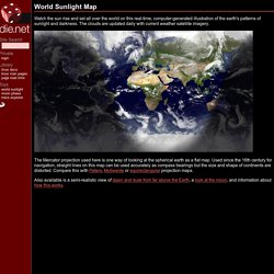
The clouds are updated daily with current weather satellite imagery. The Mercator projection used here is one way of looking at the spherical earth as a flat map. Used since the 16th century for navigation, straight lines on this map can be used accurately as compass bearings but the size and shape of continents are distorted. Nonmonogamy.