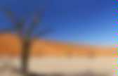
Climate. An area that features this climate usually experiences less than 250 mm (10 inches) per year of precipitation and in some years may experience no precipitation at all.
In some instances, an area may experience more than 250 mm of precipitation annually, but is considered a desert climate because the region loses more water via evapotranspiration than falls as precipitation (Tucson, Arizona and Alice Springs, Northern Territory are examples of this). To determine whether a location has an arid climate, the precipitation threshold must first be determined. Hot desert climates[edit] Regions with hot desert climates Hot desert climates are typically found under the subtropical ridge where there is largely unbroken sunshine for the whole year due to the stable descending air and high pressure. Hot desert climates feature hot, typically exceptionally hot, periods of the year. Examples[edit] Cold desert climates[edit] Regions with cold desert climates Mild desert climates[edit] Arid.
Floods. Sandstorm. Shifting Sands. Formations. Canyon. Flood Plains. River. Mesa. Oasis. Infrastructure. Buildings. Fort. Trading Post. Resource - Collection. Cactus. Mine Community. Gemstones. Aluminum. Gold. Iron. Open Pit. Sand. Quarry. Marble. Silver. Uranium. Oil Well. Oil. Plantations. Cotton. Incense. Transit. Roads. Railroads. Surface. Rock. Hamada. A hamada (Arabic, حمادة ḥammāda) is a type of desert landscape consisting of high, largely barren, hard, rocky plateaus, with very little sand because this has been removed by deflation.[1] Formation[edit] Related landforms[edit] Hamada is related to Desert pavement (known variously as reg, serir, gibber, or saï), which occurs as stony plains or depressions covered with gravels or boulders, rather than as highland plateaus.[1] References[edit] ^ Jump up to: a b "Hamada, Reg, Serir, Gibber, Saï".

Regs. Scholars debate the mechanics of pavement formation and their age.

Formation[edit] Several theories have been proposed for the formation of desert pavements.[3] A common theory suggests they form through the gradual removal of sand, dust and other fine-grained material by the wind and intermittent rain, leaving the larger fragments behind. The larger fragments are shaken into place through the forces of rain, running water, wind, gravity, creep, thermal expansion and contraction, wetting and drying, frost heaving, animal traffic, and the Earth's constant microseismic vibrations. The removal of small particles by wind does not continue indefinitely, because once the pavement forms, it acts as a barrier to resist further erosion. The small particles collect underneath the pavement surface, forming an Av soil horizon. A newer theory of pavement formation comes from studies of places such as Cima Dome, in the Mojave Desert of California, by Stephen Wells and his coworkers. Sand. Dune Sea. An erg (also sand sea or dune sea, or sand sheet if it lacks dunes) is a broad, flat area of desert covered with wind-swept sand with little or no vegetative cover.[1] The term takes its name from the Arabic word ʿarq (عرق), meaning "dune field".[2] Strictly speaking, an erg is defined as a desert area that contains more than 125 square kilometres (48 sq mi) of aeolian or wind-blown sand[3] and where sand covers more than 20% of the surface.[2] Smaller areas are known as "dune fields".

The largest hot desert in the world, the Sahara, covers 9 million square kilometres (3.5×10^6 sq mi) and contains several ergs, such as the Chech Erg ( WikiMiniAtlas 24°34′N 2°35′W / 24.57°N 2.59°W / 24.57; -2.59) and the Issaouane Erg ( Ergs are concentrated in two broad belts between 20° to 40°N and 20° to 40°S latitudes, which include regions crossed by the dry, subsiding air of the trade winds. 24°57′S 137°25′E / 24.95°S 137.42°E / -24.95; 137.42) and Great Sandy Desert (
Sources. Desert. Wiki.