GiS

TwitterFacebook
Get flash to fully experience Pearltrees
http://grass.osgeo.org/wiki/GRASS-Wiki

GRASS-Wiki - GRASS-Wiki

Welcome to the GRASS GIS Users Wiki GRASS GIS is a Geographic Information System used for geospatial data management and analysis, image processing, graphics/map production, spatial modeling, and visualization.
Une page de Wikipédia, l'encyclopédie libre. Le but de ce didacticiel est d'apprendre à créer une carte topographique vectorielle à partir de modèles numériques de terrain (MNT) issus de la Shuttle Radar Topography Mission (SRTM) de la NASA en utilisant les logiciels d'édition SIG 3DEM et GRASS GIS . L'intérêt d'utiliser les MNT de la SRTM est de nature diverse : les données sont libres (dans le domaine public), en libre accès sur le site de la NASA, précises (jusqu'à une résolution de 31 m à l'équateur), couvrent pratiquement toutes les terres habitées (80 % des terres émergées) et la source est fiable.

Wikipédia:Atelier graphique/Didacticiels cartographiques/Didacti

http://fr.wikipedia.org/wiki/Wikip%C3%A9dia:Atelier_graphique/Didacticiels_cartographiques/Didacticiel_de_cr%C3%A9ation_de_carte_topographique_vectorielle

DMAP: UTM Grid Zones of the World

There are 60 longitudinal projection zones numbered 1 to 60 starting at 180°W. 
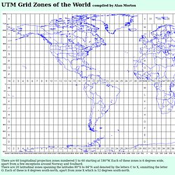
Each of these zones is 6 degrees wide, apart from a few exceptions around Norway and Svalbard. There are 20 latitudinal zones spanning the latitudes 80°S to 84°N and denoted by the letters C to X, ommitting the letter O. Each of these is 8 degrees south-north, apart from zone X which is 12 degrees south-north. Areas are referenced by quoting the longitudinal zone number, followed by the latitudinal zone letter. http://www.dmap.co.uk/utmworld.htm

GRASS GIS - The World Leading Free Software GIS

Commonly referred to as GRASS, this is free Geographic Information System (GIS) software used for geospatial data management and analysis, image processing, graphics/maps production, spatial modeling, and visualization. GRASS is currently used in academic and commercial settings around the world, as well as by many governmental agencies and environmental consulting companies. GRASS is an official project of the Open Source Geospatial Foundation . 19 Feb 2012: GRASS GIS 6.4.2 source code and selected binaries released - New stable GRASS release version 6.4.2 with improvements and stability fixes FOSS4G-CEE & Geoinformatics 2012 - FOSS4G-CEE - Free and Open Source Software for Geospatial in Central and Eastern Europe, 21-23 May 2012, Prague, Czech Republic http://grass.fbk.eu/
GIS

http://openmap.bbn.com/

OpenMap(tm)

BBN Technologies' OpenMap TM package is an Open Source JavaBeans TM based programmer's toolkit. Using OpenMap, you can quickly build applications and applets that access data from legacy databases and applications. OpenMap provides the means to allow users to see and manipulate geospatial information.