Meeting Planner – Find best time across Time Zones
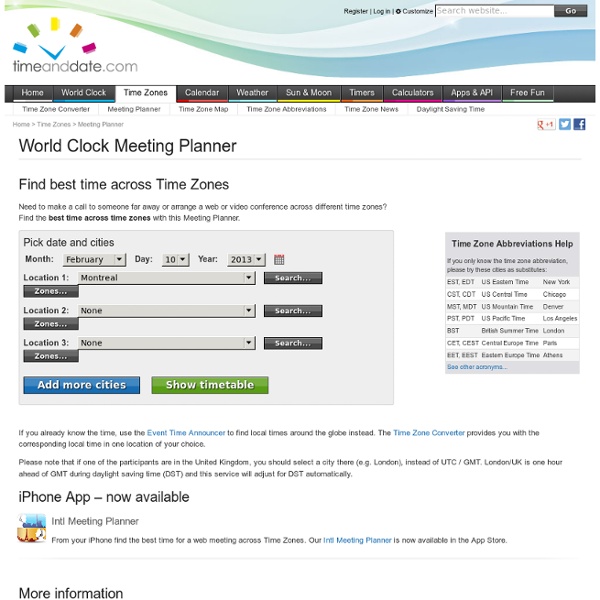
+1 this page: Follow us on Google+: Like/share this page: Follow us on facebook: Find best time across Time Zones Need to make a call to someone far away or arrange a web or video conference across different time zones? If you already know the time, use the Event Time Announcer to find local times around the globe instead. Please note that if one of the participants are in the United Kingdom, you should select a city there (e.g. iPhone App – now available Intl Meeting Planner From your iPhone find the best time for a web meeting across Time Zones. Advertising
Weekday Calculator – What Day is this Date?
+1 this page: Follow us on Google+: Like/share this page: Follow us on facebook: Want to know which day of the week you were born? Just enter the date and find out the day of the week and other fun facts about your specific date. is a Additional facts It is day number of the year, left.It is number out of in .It is number out of in .Year has days. has days. Invalid Date
My Maps
sleepyti.me bedtime calculator
Free Online Animated GIF Maker - Make A GIF Easily
Free Home Design Software and Interior Design Software - Autodesk Homestyler
YouTube
Welcome to TestTube, our ideas incubator. This is where YouTube engineers and developers test out recipes and concoctions that aren't quite fully baked and invite you to tell us how they're coming along. Your comments will help us improve and perfect the mixtures we're working on. So jump in, play around, and send your feedback directly to the brains behind the scenes. YouTube Music Discovery Make playlists and discover new artists and music videos. Try it out | Feedback?
10 Services To Send Text Messages From The Web
Sometimes you need to send a text message, but you forgot your phone, or you have poor cell reception, so what can you do? Or you just prefer the comfort of the full keyboard to the crammed one on your phone? No problem, we've got 10 sites to help you get started with staying in constant contact with your friends, families and even your customers. Bloove.com - Get your phone contacts on the Bloove site, and then log in and manage them as well as send them text messages directly from the site. ClearSMS.com - A professional SMSing service for businesses to send out mass messages to their customers to alert them about specials and sales. GizmoSMS.com - GizmoSMS lets you send texts to users in over 50 countries an a slew of carriers inside each of those. Group2Call.com - Allows you to import your contacts, break them up into groups and send all the free texts you want to them. OhDontForget.com - Not only can you text people, you can schedule them for later delivery.
Gimme Bar | Home
Related:
Related: