
50 Twitter facts that'll fascinate small businesses Lilach Lilach is the founder and driving force behind Socialable, and highly regarded on the world speaker circuit. Forbes and Number 10 Downing Street have even been graced by her presence! In a nutshell, she’s a hugely connected and highly influential serial entrepreneur – the embodiment of Digitelligence.Listed in Forbes as one of the top 20 women social media power influencers and likewise as one of the top social media power influencers, she is one of the most dynamic personalities in the social media market, she actively leverages ethical online marketing for her clients and for Socialable. After launching her first business within three years of becoming a mother, her financial success was recognised by being a finalist at the Best MumPreneur of the Year Awards, presented at 10 Downing Street. When Lilach isn’t working she enjoys spending time with her family and is an avid fan of Zumba.
Latitude et longitude d'un lieux Coin des cartes de Cassini Accueil Les cartes de Cassini sont l'oeuvre de 3 générations de cartographes de la famille Cassini. Elles ont été établies entre 1750 et 1790. La France de l'époque est découpée en 181 cartes. Il manque entre autres la Corse, la Savoie et l'Ile d'Yeu. Les cartes proviennent de la Bibliothèque Nationale de France. Ces cartes sont libres de droits pour un usage personnel : licence de la BNF. On trouve sur le site d'A. Pour des raison de place disponible, les cartes ont été réduites à une taille de 5400x3600 pixels. Attention aux temps de chargement : chaque fichier occupe en moyenne 4,8 MO. Cette page est moche, c'est indéniable, mais elle est quand même conforme aux standards du web, pour être lisible avec n'importe quel navigateur un tantinet sérieux (par exemple firefox). Vous pouvez me contacter à cette adresse : j z a arobase f r e e point f r Par manque de temps cette adresse n'est pas consultée régulièrement et il ne m'est hélas pas possible de répondre à tous les messages.
Grants and Awards Resources Finding Funds some links to external resources of interest for geography and related fields General Directories Chronicle of Philanthropy The Foundation Center AAAS Science Magazine's GrantsNet sciencecareers.sciencemag.org/funding Financial Aid GuideOnlineSchools.org Guide to Financial Aid www.onlineschools.org/financial-aid/ Foundations Alfred P. Fellowships American Geographical Society Library Short-term Fellowships www4.uwm.edu/libraries/AGSL/fellowships.cfm American Geographical Society Council Fellowships Proposal Writing Basics Chapter 11, Preparing Competitive Research Grant Proposals, Aspiring Academics (2009 www.aag.org/cs/education/edge/books The Foundation Center’s Proposal Writing Short Course Advice for Graduate Students from About.com
Ancient Civilizations To borrow from Dr. Seuss's book title, "Oh the Places You'll Go! Here's a coming attraction of the people, places, ideas, and things coming at you: Your 3.2 million-year-old human ancestor Lucy, mummies, pyramids, Cleopatra, "an eye for an eye", the birth of major religions Judaism, Christianity, Islam, Hinduism, and Buddhism, the birth of democracy, the first Olympics, Julius Caesar, gladiators, the invention of writing, paper, and the wheel, kingdoms built of stone in Africa, the Great Wall of China, the introduction of such concepts as zero, time, and monotheism (the belief in one god), Samurai, martial arts, palaces of gold, and even the Sphinx. The study of ancient civilizations and people raises some profound questions. As you explore these civilizations, see if you can make sense of this Sphinxlike statement from author William Faulkner: "The past is never dead. Knowledge of history is empowering. As Seuss promises later in that same book, "Will you succeed?
Enterprise-class Critical Information Exchange Solutions | IntraLinks Gone are the days when innovation was an ad hoc occurrence, happening at some fortunate confluence of events. To keep pace with ever-accelerating global competition, companies have institutionalized innovation as a deliberate strategic priority — and made it a continuous process. Moreover, many of the most successful companies — Apple, Johnson & Johnson and Procter & Gamble come to mind — are extended enterprises whose inter-company collaboration with a network of partners is a key enabler and accelerant of their continuous innovation processes. That's what Harvard Business Review found in its analysis of P&G's Connect + Develop initiative.1 Connect + Develop's goal is continuous innovation, and the program's web page states that "more than 50% of product initiatives at Procter & Gamble involve significant collaboration with outside innovators" — ranging from individuals and small firms to other large corporations. 'Birds of a feather' collaboration vs. 'partners on a mission'
cadastre.gouv.fr vendredi 18 avril 2014 Bienvenue sur le service de consultation du plan cadastral. Le plan cadastral français disponible en ligne est composé de 597033 feuilles de plan aux formats image ou vecteur. Ce service vous permet de rechercher, consulter et commander ces feuilles de plan. 495559 plans vecteurs101474 plans images résultats par page Préférer une recherche par références cadastrales En cas de règlements par chèque (feuilles cadastrales, réserve monétaire), veuillez impérativement libeller votre chèque à l'encre noire à l'ordre de la "Régie de recettes du SDNC" afin d'éviter tout rejet de paiement. 0 article ©2012 Ministère de l'Économie et des Finances
Home | AAG Ancient Civilizations - Dynamic 2 Moms To be ignorant of the past is to remain a child. (paraphrase from an observation by Cicero ) History is one of our very favorite subjects. I'm sure you can tell by what we upload, that we enjoy it. To help you get the best use of this page as it grows, we want to explain how it is developed. It is divided up by area or country. Obviously the continents of Europe, Africa and Asia will hold a majority of the events taking place at this time. Creation Look here on our Bible Page for a layered book for the Days of Creation depending on where you want to start with your study of history. Study of History What is History & What is Archaeology Two Tab book Mesopotamia Cover/Divider Hammurabi of Babylon flip book Sargon of Akkadia flip book (Modern Day Pakistan) Download the Indus Valley Cover here. Dnload Mohenjo-daro trifold with cover C h i n a Ancient China Cover History of Silk Leaf Book Confucius mini book Shang Warrior Four flap book Shang Script Flip book Food of Ancient China Notebook Pages Links.
Building an Enterprise Architecture value proposition using TOGAF® 9.1. and ArchiMate 2.0 When introducing Enterprise Architecture as a program or initiative, it is regularly done from an IT perspective rarely considering what the costs will be and if there will be any return on investment. This presents a particular challenge to Enterprise Architecture. Generally speaking, IT departments have all sorts of criteria to justify projects and measure their performance. They use measurements and metrics, KPIs. Going to the solution level, they commonly use indicators such as percentage uptime for systems from the System Management team, error rates for applications from the Development Support team, or number of calls resolved on the first call from the Service Desk, etc. These KPIs usually are defined at an early stage and very often delivered in dashboards from various support applications. On the other hand it is much more difficult to define and implement quantifiable measure for Enterprise Architecture. Jeanne W. Firstly the entities from the TOGAF 9.1 metamodel:
Cassini - Légende des cartes Je ne sais pas si il existe un document original décrivant les différents éléments que l'on peut relever sur les cartes, aussi je suis intéressé par tout renseignement sur ce sujet. La première légende que j'ai trouvée sur internet vient du site d'Andrée Parbelle (+ 2004), puis je l'ai retrouvée ensuite sur d'autres sites. Je la reproduis ici à mon tour. Typographie - Abréviations - Constructions humaines - Constructions isolées - Constructions religieuses - Divers - Voies - Relief César-François Cassini de Thury écrit : Les Chiffres marqués à l'angle des Cartes de l'Académie le long des Côtés désignent les distances en Toises à la Méridienne (qui passe à l'Observatoire Royal de Paris) et à la Perpendiculaire. Particularités typographiques (retour en haut) lire S (exemple : Ronesque) lire SS (exemple : Varvasse) Abréviations (retour en haut) (1) Les chiffres qui précèdent ces lettres initiales désignent les distances en toises à la Méridienne et à la Perpendiculaire de Paris.
GCSE Bitesize - Geography
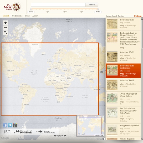
Le site se présente ainsi : "Le site web OldmapsOnline est un moteur de recherche gratuit vous permettant dappeler des cartes historiques qui se trouvent dans les collections de diverses bibliothèques.Quiconque voulait visionner jusquil y a peu des cartes historiques sous forme numérique pour effectuer des recherches ou par simple intérêt, devait savoir dans quelle collection cartographique la carte voulue se trouvait. Le site web OldmapsOnline est un nouveau portail qui permet de passer en revue les collections de cartes de différentes bibliothèques.Tout comme Google Maps, le nouveau moteur de recherche de cartes utilise une carte mondiale sur laquelle il est possible de zoomer sur l'emplacement recherché. Mais l'on peut aussi entrer le nom de l'endroit à propos duquel l'on souhaite solliciter danciens cartes. Un réglage coulissant permet de demander des cartes d'une période de temps spécifique." by pixis Mar 10