background preloader

Where is Earth's water? USGS Water-Science School

Where is Earth's water? USGS Water-Science School
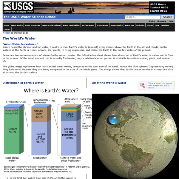
The USGS Water Science School "Water, Water, Everywhere...."You've heard the phrase, and for water, it really is true. Earth's water is (almost) everywhere: above the Earth in the air and clouds, on the surface of the Earth in rivers, oceans, ice, plants, in living organisms, and inside the Earth in the top few miles of the ground. Below are two representations of where Earth's water resides. The left-side bar chart shows how almost all of Earth's water is saline and is found in the oceans. The globe image represents how much actual water exists, compared to the total size of the Earth. Distribution of Earth's Water In the first bar, notice how only 2.5% of Earth's water is freshwater - the amount needed for life to survive. View a larger version of this image and learn more. All of the World's Water Earth's freshwater

Terminology Infographic: Three Eras of Water — The History of the Relationship Between Civilization and Nature Entry in the 2011 Urban Water Design Challenge, sponsored by Visualizing.org and Circle of Blue. Carlo Llacar submitted this infographic for the 2011 Urban Water Design Challenge—sponsored by Circle of Blue and Visualizing.org. Graphic © Carlo Llacar for Circle of Blue and Visualizing.org This “info-art,” or infographic*, is based on Peter Gleick’s essay, “Facing Down the Hydro-Crisis.” It encapsulates the relationship history between man and water, as divided into the three eras described by Gleick. The infographic portrays the evolution of water technology, including its immediate successes of human progress and the disadvantages of that progress. See the other winning designs here. Did you miss your chance to participate? *”Facing Down The Hydro-Crisis” was originally published in the World Policy Journal (©2009 World Policy Institute : used by permission), and this infographic originally appeared in the book Safe Agua (©2010 Designmatters at Art Center College of Design).

Description of Hydrologic Cycle This is an education module about the movement of water on the planet Earth. The module includes a discussion of water movement in the United States, and it also provides specific information about water movement in Oregon. The scientific discipline in the field of physical geography that deals with the water cycle is called hydrology. It is concerned with the origin, distribution, and properties of water on the globe. Consequently, the water cycle is also called the hydrologic cycle in many scientific textbooks and educational materials. The global water cycle can be described with nine major physical processes which form a continuum of water movement. The information presented below is a greatly simplified description of the major contributing physical processes. Evaporation occurs when the physical state of water is changed from a liquid state to a gaseous state. Condensation is the process by which water vapor changes it's physical state from a vapor, most commonly, to a liquid.

Harvard Students Win Urban Water Design Challenge for Interactive Water Footprint Infographic Three weeks, 36 entries: Global competition sponsored by Circle of Blue and Visualizing.org. For their interactive water footprint graphic, Joseph Bergen and Nicki Huang—students at the Harvard Garduate School of Design—earned top honors in the Urban Water Design Challenge, sponsored by Circle of Blue and Visualizing.org. The winners were announced on March 22, the eighteenth annual World Water Day. The winning graphic, “What is Your Water Footprint?”, explores water consumption based on location and lifestyle. Infographic © Joseph Bergen and Nicki Huang for Circle of Blue and Visualizing.org “What Is Your Water Footprint?” The Urban Water Design Challenge was an ambitious and rapid-fire call to designers, data experts, visualizers, cross-disciplinary thinkers, and cutting-edge creative teams to tap into the world’s stream of water data. “The world water crisis is profoundly complex and interrelated,” said J. The panel of judges included: “Can We Keep Up?”

The Hydrological Cycle | S-cool, the revision website This describes the process whereby water in its various forms is continually cycled between the land, sea and atmosphere. It also makes its way into the biosphere to influence animal and plant ecosystems around the globe. This is a common approach in geography and the two main examples in this topic are: The hydrological cycle: a closed system. The drainage basin system: an open system. Both consist of transfers, stores, inputs of water but the hydrological cycle is a closed system as no gains or losses from outside are added to the system. The drainage basin system is said to be open as both inputs and outputs of energy and material occur. Within the hydrological cycle, four main processes operate: 1. This is when plants prevent some rainfall from directly reaching the ground, for example, water on leaves or foliage. 2. Water lost from vegetation via both evaporation and transpiration. Potential Evapotranspiration: The amount of water that could be lost by evapotranspiration. 3. 4. Flow:

The Water Cycle summary, USGS Water Science School What is the water cycle? What is the water cycle? I can easily answer that—it is "me" all over! The water cycle describes the existence and movement of water on, in, and above the Earth. Earth's water is always in movement and is always changing states, from liquid to vapor to ice and back again. The water cycle has been working for billions of years and all life on Earth depends on it continuing to work; the Earth would be a pretty stale place without it. Where does all the Earth's water come from? A quick summary of the water cycle Here is a quick summary of the water cycle. The water cycle has no starting point, but we'll begin in the oceans, since that is where most of Earth's water exists. Air currents move clouds around the globe, and cloud particles collide, grow, and fall out of the sky as precipitation. Not all runoff flows into rivers, though. Main components of the water cycle Global water distribution Water storage in oceans: Saline water existing in oceans and inland seas

Water cycle Diagram of the Water Cycle As the Earth's surface water evaporates, wind moves water in the air from the sea to the land, increasing the amount of freshwater on land. Water vapor is converted to clouds that bring fresh water to land in the form of rain snow and sleet Precipitation falls on the ground, but what happens to that water depends greatly on the geography of the land at any particular place. The water cycle involves the exchange of energy, which leads to temperature changes. The evaporative phase of the cycle purifies water which then replenishes the land with freshwater. Description Processes Many different processes lead to movements and phase changes in water Condensed water vapor that falls to the Earth's surface. The precipitation that is intercepted by plant foliage eventually evaporates back to the atmosphere rather than falling to the ground. Snowmelt The runoff produced by melting snow. The variety of ways by which water moves across the land. Subsurface flow Evaporation See also

The Water Cycle : Feature Articles By Steve Graham, Claire Parkinson, and Mous Chahine Design by Robert Simmon October 1, 2010 A previous version of this article, published in 2000, is now archived as a PDF file. Viewed from space, one of the most striking features of our home planet is the water, in both liquid and frozen forms, that covers approximately 75% of the Earth’s surface. Geologic evidence suggests that large amounts of water have likely flowed on Earth for the past 3.8 billion years—most of its existence. Believed to have initially arrived on the surface through the emissions of ancient volcanoes, water is a vital substance that sets the Earth apart from the rest of the planets in our solar system. In particular, water appears to be a necessary ingredient for the development and nourishment of life. Earth is a water planet: three-quarters of the surface is covered by water, and water-rich clouds fill the sky. Water, Water, Everywhere Water is practically everywhere on Earth.

Drainage basin "Catchment basin" redirects here. For the human geography concept, see Catchment area. Example of a drainage basin. A drainage basin or catchment basin is an extent or an area of land where surface water from rain, melting snow, or ice converges to a single point at a lower elevation, usually the exit of the basin, where the waters join another waterbody, such as a river, lake, reservoir, estuary, wetland, sea, or ocean. Other terms that are used to describe drainage basins are catchment, catchment area, drainage area, river basin and water basin.[1] In North America, the term watershed is commonly used to mean a drainage basin, though in other English-speaking countries, it is used only in its original sense, to mean a drainage divide,[2] the former meaning an area, the latter the high elevation perimeter of that area. The drainage basin acts as a funnel by collecting all the water within the area covered by the basin and channelling it to a single point. Map[edit] Ocean basins[edit]

Related: