Changing Channel characteristsics
Width and depth are simple variables and generally increase downstream as more water is added from tributaries. Width can be derived either from the water surface width (occupied channel width) or from measuring from bank to bank, giving the bank full width. We can calculate the stream order from source to mouth too, and this gives us an indication of the size and shape of river channels. Stream order 1 streams have NO tributaries feeding into them, they are the original streams that start at springs up in the source. Stream order 2 streams occur where two stream order 1 rivers come together at a confluence Stream order 3 streams occur where two stream order 2 rivers come together at a confluence (not a stream order 2 with a 1, it must be the SAME stream order meeting) The stream order continues like this. Cross sectional area is another useful measure, and it shows in metres squared the surface area of a river is you could take a slice through (and stop the water!) Source
IGCSE Rivers and GCSE Rivers
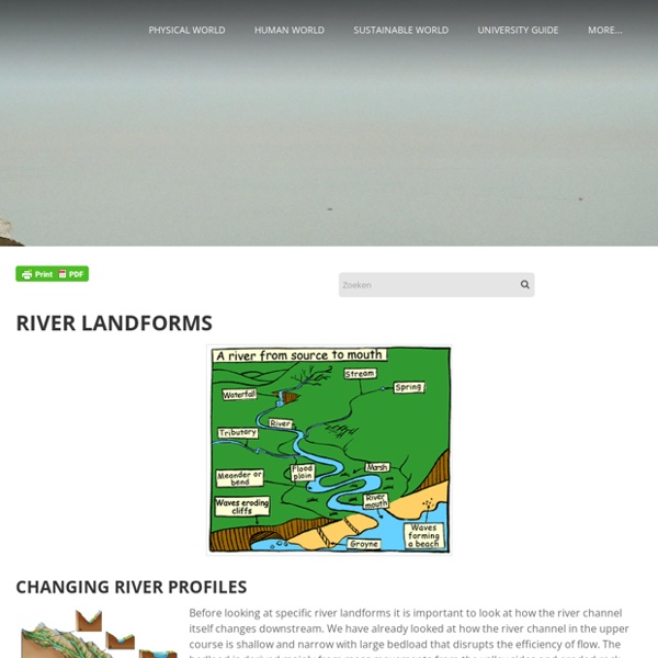
Specification:2.2.2 River processes Candidates should be able to: • Demonstrate an understanding of the work of a river in eroding, transporting and depositing. Reference should be made to the erosional processes of hydraulic action, corrasion, corrosion (solution) and attrition. River transport should include the processes of traction, saltation, suspension and solution. Reasons why and where in a river’s course deposition takes place should be studied. It should be realised that the effectiveness of the river processes concerned will vary according to the volume and velocity of the running water and the nature of the load (boulders, pebbles, sand and silt) which, in turn, will be affected by the bedrock along the course of the river. • Describe and explain the landforms associated with these processes. Key River Terminology River Long Profile: The long profile is the course the river takes from its source to its mouth. River Processes (Erosion, Transportation and Deposition) Key words:
Deltas
NWS Education Resources
This page offers information for children, teens and adults. Materials range from coloring books, puzzles and games, to lesson plans, brochures, satellite images, and career information for weather related fields, such as meteorology, hydrology and climatology. Classroom Materials Student Sites Graphics, Photos, Images Glossary Glossary of Weather Terms Other Weather Sites Careers/Classes in Weather General Resources (NWS is not endorseing these sites, merely providing a service.)
UK winter storms
20 February 2014Last updated at 08:14 ET January's wet weather in numbers Slow threat of groundwater flooding The reasons behind one of the stormiest months Turbulent seas and wave watchers being caught out Aerial imagery and photos along the Thames Eyewitness accounts from storm-hit areas The Army moves in for a "rapid inspection" of flood defences The impact of the floods on wildlife How bad are 2014's floods compared with 2007?
The Water Cycle for Kids and Students
The water cycle describes how Earth's water is not only always changing forms, between liquid (rain), solid (ice), and gas (vapor), but also moving on, above, and in the Earth. This process is always happening everywhere. Back to the water cycle diagram for students. Animals In the grand scheme of the water cycle, animals may not play a very big role, but all animals, including you, participate in moving water around as part of the water cycle. The water cycle is critical to all animals and life on Earth. There is one creature on Earth that does have a very large impact on the water cycle—human beings. Atmosphere The atmosphere truly is the superhighway in the sky that moves water everywhere over the Earth. The next time you go outside you will be standing in the Earth's atmosphere. The air outside may look invisible, but it is full of molecules, including water molecules, as water vapor. How much does a cloud weigh? Clouds are made of water, and water has weight, so how can they float? Lakes
Big Dams: Boon or Bane?
The Mekong River arises in the Tibetan Plateau of southern China and descends through a series of spectacular gorges into Laos, Cambodia, and Vietnam. The lower river widens into vast marshlands and deltas, upon which hundreds of thousands of people depend for their livelihood. Multiple dam projects, some completed, some under construction, and others planned, are dramatically changing the face of the river. The DON SAHONG DAM is under construction in Laos, just north of the Cambodian border, one of nine Mekong dams planned by the Laotian government. Immediately downriver is the habitat of the Iriwaddy Dolphin; fewer than 100 remain on the river. The XAYABURI DAM in northern Laos is in the latter stages of completion. These and other dams on the upper Mekong dramatically reduce the flow of sediments to the Tonle Sap wetlands in Cambodia and the Mekong Delta in Vietnam.