
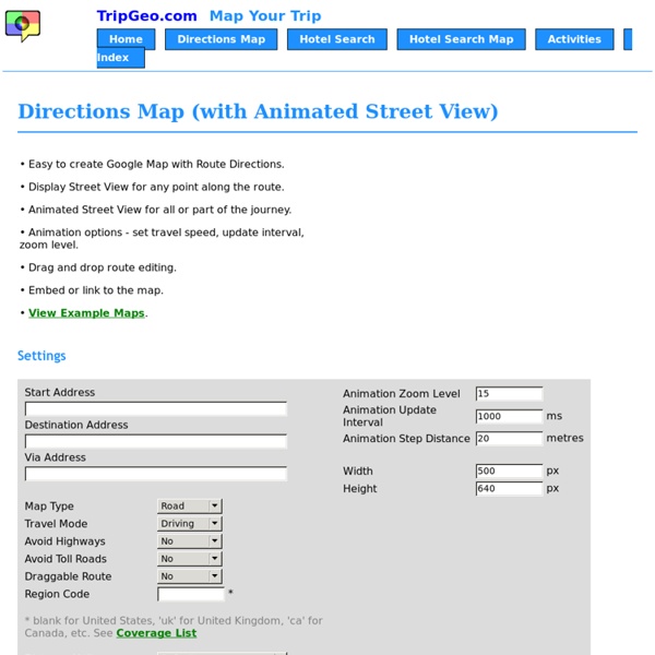
http://tripgeo.com/DirectionsMap.aspx
5 Artistic Uses of Google Street View Mark Wright is a freelance arts writer and assistant editor of the Image Source blog. People are using Google Street View for more than checking travel routes. You can use the mapping tool to test hotel neighborhoods, to take virtual tours of the world’s most famous art galleries, or to arrange imagery for innovative photography and video projects. SEE ALSO: Top 28 Google Street View Sightings The Google Street View (GSV) car, fitted with 15 directional cameras, captures panoramas from over 30 countries – but not without controversy.
Geography Websites - Presentation Primary School, Sexton Street, Limerick. Tel: 061-412494 Explore Geography on Coxhoe Durham Planet Earth in Space - Take a virtual tour through our Solar System. See how the Planets move around the Sun and zoom in on each. All About Weather: Weather for Senior Classes Weather and People
disposablewebpage.com Hello World. This is LMWIFY, short for “Let Me Write It For You”. LMWIFY lets you create simple yet stunning looking messages on a canvas and distribute it as an image to your family and friends. Create an interactive street view with jQuery | Tutorial | .net magazine net magazine is the number one choice for the professional web designer and developer. It’s here that you find out about the latest new web trends, technologies and techniques – all in one handy package. Each issue boasts a wealth of expert tips and advice, including in-depth features and over 30 pages of advanced front- and backend tutorials on subjects as diverse as CSS, HTML, JavaScript, WordPress, PHP, and plenty more. net compiles the hottest new sites from around the web, and being the voice of web design, our mission is to source the best articles written by the best people in the industry and feature interviews and opinions crammed with inspiration and creative advice. In short, If you're serious about web design and development, then net is the magazine for you.
5 Map Creation Activities for Geography Awareness Week Next week is Geography Awareness Week. As a social studies teacher I think every week should be Geography Awareness Week, but I digress. Looking at maps is fine, making maps is better. Here are five map creation activities that your students can do to increase their understanding of geography. 1. Create a map of a memories. Powerful tool for creating web surveys. Online survey software made easy! SurveyMonkey™ Thanks for completing this survey.Now create your own—it's free, quick & easy! Create free surveys in just a few minutes Ask questions in over 15 formats(configured for you and ready to go!) Get answers to any type of question Register with SurveyMonkey today!
How to Create a Time-Lapse Movie with Google Street View This tutorial describes how you can quickly create a time-lapse movie using Street View imagery from Google Maps and publish it to YouTube in HD. I made a short time-lapse movie today using Street View images from Google Maps and playing them all in a quick sequence with some background music. The end result, as you may have noticed in the video, is quite similar to the view that you would get if you were actually driving on that road while sitting inside the Street View car.
20 Good Map Creation Tools for Students A couple of years ago I published a list of 21 online map creation tools. Since then some of those tools have gone offline and new tools have replaced them. Here's my updated list of online map creation tools for students and teachers. Wikia Maps is a map creation tool from Wikia. Wikia Maps has two map creation options. Build a simple GIS web application using GeoDjango and Google Maps — Tutorials 1.1.0 documentation By the end of this tutorial you will have built a simple GIS web application for viewing, editing, searching and uploading GIS data. We first presented this tutorial as part of a three-hour session on Working with Geographic Information Systems in Python during the 2009 Python Conference in Chicago, Illinois. This tutorial has been updated to work with Django 1.3. Example Make sure that the latest version of GeoDjango is installed; see Install GeoDjango. Start PostgreSQL server.
3 Interesting Tools for Creating Maps with Students June 16, 2015 Today we are introducing you to some good web tools to use for creating maps with students. These are new tools that we are featuring here for the first time. Using these tools students will be able to create custom maps, draw on maps, insert text and custom images to their maps, place markers, and many more. 1- ZeeMaps
Six Fun Games for Geography Awareness Week - And Tools To Make Your Own This week is Geography Awareness Week. As always, National Geographic offers a collection of educational activities for the week. I have also put together a collection of online activities to use during Geography Awareness Week. Those games are summarized below. Spacehopper is a game based on Google Maps Street View imagery. Spacehopper shows you a Street View image and you have to guess where in the world the image was captured.
Great Educational Web Tools for Making Virtual Field Trips May 5, 2015 Learning doesn't only happen in the classroom. It can happen anywhere. Here are some teacher-tested tools to take you places, whether it be physically or virtually. Make an adventure out of learning. Google Earth lessons Using Google Earth in the classroom Teaching ideas, guides, downloadable files and links to other resources can all be found at Juicy Geography's Google Earth blog. This page is regularly updated, and features original lesson plans and resources, suitable for KS3, KS4 and K12, that have all been thoroughly tested in the classroom. The lessons include: