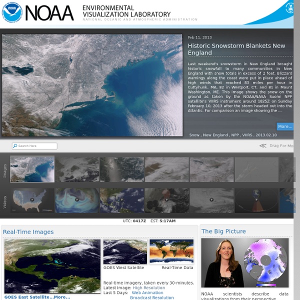
background preloader

Animations and images featuring NOAA's remotely-sensed data

Animations and images featuring NOAA's remotely-sensed data

Hurricane Irene: 12 Ways to Track the Storm Online There's a lot of excitement on the East Coast this week. In addition to Tuesday's earthquake, Hurricane Irene will likely make an appearance this weekend in the Carolinas and possibly elsewhere. As I write this, Hurricane Irene is wreaking havoc on the north coast of the Dominican Republic, but who knows where it will go? Predicting the path of a hurricane is notoriously difficult work. Image courtesy of iStockphoto, Eric Hood Cyclone Center Educational Partnership Program MPRES Real Time Hazard Summary WTC/MPRES Real Time Hazard Summary This page is automatically generated by our computers as part of ongoing research by Watson Technical Consulting and the University of Central Florida Dept. of Statistics. For more information please see our research page . If you want reliable hazard and damage estimates for insurance, engineering, oil and gas forecasts, electrical outages, and other data, try Kinetic Analysis Corporation . For discussions on what (if anything) this stuff means, as well as lots of other data, check out our blog and hazard disucssion . WARNING! Sun Mar 31 10:52:08 UTC 2013 Tropical Cyclone Hazards Shown as open circles on map. Latest DB Update: SH922013 | 2013-03-31 04:02:16.015471 | WEB | UCAR Earthquake Hazards Shown as squares on map. Latest event in catalog: 2013-03-31 10:45:38 US Local Storm Reports Last six hours (Google Earth) Last 24 hours (Google Earth) Special Projects North Korea Nuclear Test Monitor KMZ (Google Earth File)

Haiyan, le typhon le plus puissant de l'histoire? Le typhon Haiyan qui a atteint les côtes des Philippines ce vendredi 8 novembre au matin est-il le plus violent de l’histoire? C’est l’avis de plusieurs météorologues, dont l’Américain Jeff Masters qui écrivait sur le blog de son site Wunderground.com dans la nuit de jeudi à vendredi: «Trois heures avant qu’il atteigne la côte, le Joint Typhoon Warning Center (JTWC) estimait qu’Haiyan provoquait des vents de 314 km/h avec des pointes à 378 km/h, ce qui en fait le quatrième cyclone tropical le plus fort de l’histoire mondiale. La prochaine estimation d’intensité du JTWC, pour minuit TUC le 8 novembre, soit trois heures environ après qu’il ait atteint la côte, fait état de vents de 298 km/h. publicité Un avis partagé par un de ses confrères, Morgan Palmer, qui écrit sur Twitter, avec un peu plus de réserve: Do I think #Haiyan will be the strongest in recorded history to make landfall. On ne connaît pas pour le moment l’étendue des dégâts. An amazing comparison between #Katrina and #Haiyan.

Sea Grant > Home MD-DE-DC- Streams "Drought is a condition of moisture deficit sufficient to have an adverse effect on vegetation, animals, and man over a sizeable area." The following questions and answers provide background on some of the scientific issues regarding drought. For questions on regulatory issues, such as water-use restrictions in states and localities, please refer to the appropriate authority in your jurisdiction. Questions and answers are original compositions or are compiled from any available sources and credit is given where appropriate. Weather and Drought What causes drought? A drought is a period of drier-than-normal conditions that results in water-related problems. The amount of rain and snow also varies with the seasons. When no rain or only a very small amount of rain falls, soils can dry out and plants can die. Reference: Moreland, 1993. • Return to Top of Page When does a drought begin? The beginning of a drought is difficult to determine. Does a shortage of rain mean that a drought will occur?

Incredible images and video of Super Typhoon Haiyan Super Typhoon Haiyan, called Yolanda in the Philippines, struck the Philippines in the early morning hours of November 8, 2013 as one of the strongest tropical cyclones to make landfall in recorded history. At landfall, it was producing sustained winds at 195 miles per hour (mph) with gusts as high as 225 mph. We are still receiving information regarding damages and possible deaths. I have seen pictures of storm surge flooding towns and strong winds blowing debris into the air. Catastrophic damage will occur: A high percentage of framed homes will be destroyed, with total roof failure and wall collapse. This natural color satellite image of Super Typhoon Haiyan over the Philippines. was acquired at 2:10 p.m. local time (5:10 UTC) on November 8, 2013, when winds were estimated to be 270 kph (165 mph). NASA Astronaut Karen Nyberg aboard the International Space Station captured this image of Super Typhoon Haiyan over the Philippines on November 9, 2013. Image credit: NOAA

NOAA's Satellite and Information Service (NESDIS)

Related: