
Atlas for The Blind 1837 The Atlas of the United States Printed for the Use of the Blind was published in 1837 for children at the New England Institute for the Education of the Blind in Boston. Without a drop of ink in the book, the text and maps in this extraordinary atlas were embossed heavy paper with letters, lines, and symbols. To the best of our knowledge, this is the first atlas produced for the blind to read without the assistance of a sighted person. Braille was invented by 1825, but was not widely used until later. It represented letters well, but could not represent shapes and cartographic features. Samuel Gridley Howe (1801-1876) was the founder and president of the New England Institute (later known as the Perkins Institute) and produced the atlas with the assistance of John C. Below is the first map in the atlas, of Maine, with dotted lines showing the border with Canada and New Hampshire. The text page titled "map of maine, explanation" that follows the Maine map: The map of Florida:
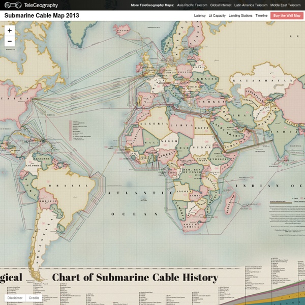
Carte: les 263 câbles sous-marins (et 22 à venir) par lesquels passe l'Internet mondial Temps de lecture: 2 min La société d'études TeleGeography a mis en ligne une carte mondiale interactive des câbles sous-marins qui connectent l'Internet mondial. «Ces grosses artères comptent pour pratiquement tout notre trafic internet international», explique le site io9. via TeleGeography CNN a interviewé Alan Mauldin, le directeur de la recherche de TeleGeography, qui a détaillé le contenu de cette carte mise à jour en permanence –elle présente l'itinéraire emprunté par 263 câbles existants et 22 annoncés. «Il peut manquer quelques plus petits câbles nationaux, mais pour les sytèmes internationaux –les plus importants– c'est exhaustif». «Pour les communications internatonales, plus de 99% [du trafic] passe par les câbles sous-marins. «Les satellites [...] sont utiles pour les communautés rurales et les lieux très isolés. La plupart des pays disposent de plusieurs points d'entrée mais les îles Tonga n'ont, par exemple, qu'un seul câble. Temps de lecture: 2 min via TeleGeography
Flightradar24.com - Live flight tracker! Albert Regnard (1832 - 1903) AirTraffic LIVE