
https://earthbuilder.google.com/10446176163891957399-13737975182519107424-4/mapview/
Related: Geography25 National Flags And Their Meanings Originating on battlefields as a means of identification, national flags have come a long way since their bloody conception. Flying in courthouses, classrooms, and fire stations they typically hold symbolic significance for the nation and have complex meanings ingrained into their designs. So go ahead and test yourself on your flag knowledge because these are 25 national flags and their meanings. Combining the crosses of the patron saints of England, Wales, and Scotland, the Union Jack as it is sometimes called is one of the oldest flags in the world having been around since 1801.
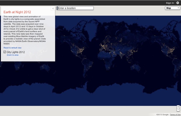
The Nighttime Earth SAN FRANCISCO — The Earth at night looks more beautiful than it ever has before in these incredible new images from NASA's Suomi NPP satellite. These super-high-resolution images, made possible by a new type of infrared sensor on the satellite, were revealed here at the American Geophysical Union conference Dec. 5.The Visible Infrared Imaging Radiometer Suite has a "day-night band" that can detect natural and man-made light with unprecedented resolution and clarity. It can resolve everything from the nocturnal glow of the atmosphere to the light of a single boat at sea. It can detect auroras, wildfires, the reflection of moon and star light off clouds and ice and the lights alongside highways. The sensor has six times better spatial resolution and 250 times better resolution of lighting levels than anything that came before it.The VIIRS instrument works by scanning in 22 different wavelength bands.
Kids' Corner, State of Alaska Alaska Facts State Nick Name: "The Last Frontier" - the name Alaska is derived from the Aleut word "Aleyska," meaning "great land." State Motto: "North to the Future" State Capital: Juneau, located in the Southeast region of Alaska, has a population of 31,275 (2010 Census) Alaska Map:
Global Views on Morality Do you personally believe that married people having an affair is morally acceptable, morally unacceptable, or is it not a moral issue? Do you personally believe that gambling is morally acceptable, morally unacceptable, or is it not a moral issue? Do you personally believe that homosexuality is morally acceptable, morally unacceptable, or is it not a moral issue? Do you personally believe that having an abortion is morally acceptable, morally unacceptable, or is it not a moral issue? 40 Maps That Will Help You Make Sense of the World If you’re a visual learner like myself, then you know maps, charts and infographics can really help bring data and information to life. Maps can make a point resonate with readers and this collection aims to do just that. Hopefully some of these maps will surprise you and you’ll learn something new. A few are important to know, some interpret and display data in a beautiful or creative way, and a few may even make you chuckle or shake your head. If you enjoy this collection of maps, the Sifter highly recommends the r/MapPorn sub reddit. You should also check out ChartsBin.com.
Top 60 Chinese Cities Cities are one of the many phenomena that follow a long-tailed distribution. In simple terms there are a few big cities and lots of small ones. The classic way of showing a long tailed distribution (and the method from which the name is taken) is to produce as plot such as that below: The infographic at the top of the post by chinfographics.com demonstrates the distribution in a more engaging and constructive way. One method I have used in the past to demonstrate data with a long tailed distribution is the excellent Wordle tool. 40 maps that explain the world By Max Fisher By Max Fisher August 12, 2013 Maps can be a remarkably powerful tool for understanding the world and how it works, but they show only what you ask them to. So when we saw a post sweeping the Web titled "40 maps they didn't teach you in school," one of which happens to be a WorldViews original, I thought we might be able to contribute our own collection. Some of these are pretty nerdy, but I think they're no less fascinating and easily understandable. A majority are original to this blog, with others from a variety of sources.
Early world maps Antiquity Babylonian Imago Mundi (c. 600 BCE) A Babylonian world map, known as the Imago Mundi, is commonly dated to the 6th century BCE.[1][2] The map as reconstructed by Eckhard Unger shows Babylon on the Euphrates, surrounded by a circular landmass showing Assyria, Urartu (Armenia)[3] and several cities, in turn surrounded by a "bitter river" (Oceanus), with seven islands arranged around it so as to form a seven-pointed star. The accompanying text mentions seven outer regions beyond the encircling ocean. The descriptions of five of them have survived:[4]
Guess the Travel Destination! Inspiration for your next Break No matter what your budget allows, we will help you save your pennies. Lovers of a luxury board basis such as full-board or all-inclusive will rejoice when they see the choice. Meanwhile, those that prefer to fly solo have plenty of options from self-catered apartments to glamping getaways. Of course if it’s all about the accommodation and the facilities, take a peek at our luxury hotels and spa breaks for couples. Spoiling you is the aim of the game when it comes to our high-end holidays.
From Ptolemy to GPS, the Brief History of Maps Last spring, a 23-year-old woman was driving her car through the Ontario town of Tobermory. It was unfamiliar territory for her, so she was dutifully following her GPS. Indeed, she was so intent on following the device that she didn’t notice that her car was headed straight for Georgian Bay—so she drove down a boat launch and straight into the frigid water. She thankfully managed to climb out and swim to shore, as her bright red Yaris sank beneath the waves. Accidents like this have become weirdly common. In Manhattan, one man followed his GPS into a park, where his car got stuck on a staircase. Three Geography Games Based on Google Maps and Google Earth One of the things that I emphasize to students before they embark on any kind of research or problem-solving task is to take a good long look at the information that they already have before them. To that end, I'll often request that they construct a list of what they know about a topic or problem before they begin to search. Playing one of the following three Google Maps-based games is a fun way to reinforce the concept of using prior knowledge and observations. GeoGuessr is an addictive geography game that is based on the Google Maps Street View imagery.
51 World Geography Games for Kids World Geography Games is a free site that features 51 geography games. The games are simple identification games in which students are shown the name of a country, state, city, or geographic feature and then have to click on the correct locations. Students earn points for each correct answer. The 10 Worst River Basins Contributing to Ocean Plastics “[A new paper], published in the journal Environmental Science and Technology, calculates that rivers contribute between 410,000 and 4 million tonnes a year to oceanic plastic debris, with 88 to 95% [of that total] coming from only 10. Those rivers are the Yangtze, Yellow, Hai He, Pearl, Amur and Mekong in east Asia, the Indus and Ganges Delta in south Asia, and the Niger and Nile in Africa.” Source: cosmosmagazine.com Of river-based plastic pollution, these 10 rivers are responsible for 88%-95% of all the plastic gyrating in the world’s oceans. Improvement in these key places could make a world of difference in improving marine ecosystems (NOTE: the map came from this alternative article on the same subject). Tags: pollution, water, environment, sustainability, consumption, fluvial.