L'irrésistible ascension de la géolocalisation
Cela devait arriver. A force de remplir son mur sur Facebook, de bavasser sur Twitter, de planter des check in sur Foursquare à chaque fois qu'on met les pieds dans une boutique, on a fini par exciter la convoitise des professionnels du marketing. Leur objectif ? Prouver aux annonceurs que la relation entre la marque et le consommateur ne se limite plus simplement aux rayons d'un magasin ou à son site internet, mais qu'elle est devenue omniprésente et permanente. Bingo ! Il suffit que je me promène dans une rue commerçante avec mon smartphone en poche pour recevoir directement des alertes, par SMS, sur des offres promotionnelles proposées dans le quartier. Boostés par l'explosion du marché des smartphones - soit un tiers des téléphones mobiles vendus en France -, les services de géolocalisation engendrent un buzz très fort. Le syndrome du "check in fatigue" Véritable concept fourre-tout, la géolocalisation a commencé à se développer en 2005. Le second souffle Des questions éthiques
- Tous savoir sur la géolocalisation
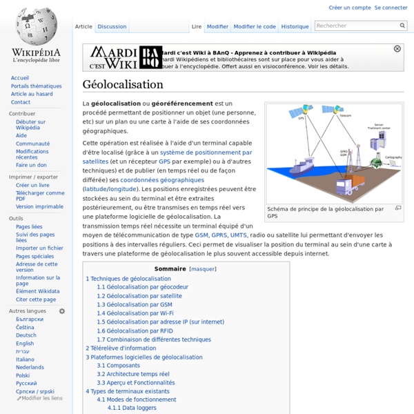
La géolocalisation ou géoréférencement est une
List of photo sharing websites
This is a non-exhaustive list of major photo-sharing websites. Active photo-sharing websites[edit] Defunct photo-sharing websites[edit] These also include sites that may still operate, but do not accept new users. Listed in chronological order of shutdown. Comparison of photo-sharing websites[edit] Legend: References[edit]
Etat des lieux du marché mobile en septembre 2011
Mardi 11 octobre 2011 2 11 /10 /Oct /2011 12:15 Voici un diaporama de l’agence Dagobert qui nous présente une synthèse du marché mobile en septembre 2011, une synthèse très utile vis à vis de la vitesse à laquelle évolue ce marché. Les points que je retiens : De nombreux chiffres et informations complémentaires dans le diaporama : Billets en relation : Partager l'article ! inShare Par Julien Bonnel - Publié dans : Technologies 2
geolocalisation
Geotagging
Geotag information in a JPEG photo, shown by the software gThumb The related term geocoding refers to the process of taking non-coordinate based geographical identifiers, such as a street address, and finding associated geographic coordinates (or vice versa for reverse geocoding). Such techniques can be used together with geotagging to provide alternative search techniques. Geotagging techniques[edit] The geographical location data used in geotagging will, in almost every case, be derived from the global positioning system, and based on a latitude/longitude-coordinate system that presents each location on the earth from 180° west through 180° east along the Equator and 90° north through 90° south along the prime meridian. Geotagging photos[edit] There are two main options for geotagging photos; capturing GPS information at the time the photo is taken or “attaching” the photograph to a map after the picture is taken. GPS formats[edit] Geotagging standards in electronic file formats[edit]
Des réseaux sociaux mobiles stimulés par la géolocalisation
Les services de localisation multiplient les applications pour plates-formes sociales mobiles. Contrairement aux attentes, les modèles de revenus ne seront pas dus principalement aux services de publicité géolocalisée. Pouvoir envoyer des messages et photos en tout lieu n'est pas le seul ingrédient du succès des réseaux sociaux sur mobiles. Les services de géolocalisation, qui se multiplient sur les téléphones portables, sont un autre atout majeur : ils permettent en effet aux utilisateurs de partager leur expérience sur des lieux, mais aussi de savoir en permanence où sont leurs amis ou d'autres personnes susceptibles d'avoir les mêmes goûts qu'eux. Les réseaux qui utilisent cette technique devraient d'ailleurs générer plus de 3,3 milliards de dollars en 2013, annonce ABI Research dans une étude. Mais contrairement aux prédictions, ces revenus ne seront pas générés principalement par la publicité.
Principe du système de localisation GPS
Généralités : Le principe de localisation GPS repose sur l'émission de signaux codés véhiculés par une onde porteuse, selon deux modes de fonctionnement : - un mode précis de positionnement à priori réservé à des utilisateurs identifiés (code P ; précision de l'ordre de 10m) - un mode standard de positionnement, sans restriction d'utilisation (code C/A ; précision de l'ordre de 100 m). Un récepteur reçoit donc simultanément les signaux codés en provenance de plusieurs satellites situés à des distances différentes du lieu d'observation. A noter que la précision centimétrique nécessaire dans des domaines tels que la géophysique requiert le traitement d'informations sur la phase de l'onde porteuse elle-même, opération qui ne peut être effectuée qu'en différé, à l'aide d'un système de traitement spécifique. Eléments d'explication : L'onde porteuse émise par un satellite GPS se propage dans toutes les directions à la vitesse c = 300 000 km.s-1.