
The Internet map The map of the Internet Like any other map, The Internet map is a scheme displaying objects’ relative position; but unlike real maps (e.g. the map of the Earth) or virtual maps (e.g. the map of Mordor), the objects shown on it are not aligned on a surface. Mathematically speaking, The Internet map is a bi-dimensional presentation of links between websites on the Internet. Charges and springs To draw an analogy from classical physics, one may say that websites are electrically charged bodies, while links between them are springs. Also, an analogy can be drawn from quantum physics. Anyway, the real algorithm of plotting The Internet map is quite far from the analogies given above. Semantic web The map of the Internet is a photo shot of the global network as of end of 2011 (however, baloons show actual statistics from Alexa). Importantly, clusters on the map are semantically charged, i.e. they join websites together according to their content. The Internet Phenomenon Ideas and suggestions
7 Educational Uses for 3D Printing - Getting Smart by Guest Author - EdTech, higher ed, Innovation By Nancy Parker When someone says that they have a 3D printer, many people visualize a printer that produces 3D images on a sheet of paper. In actuality, a 3D printer goes beyond an image on paper and brings the object to life in real 3D. 1. 2. 3. 4. 5. 6. 7. If it can be created in a supported 3D rendering program, it can exist in real life. Nancy Parker writes about wide range of subjects like health, Parenting, Child Care, Babysitting, nanny, www.enannysource.com/ etc. Photo Courtesy of Makerbot
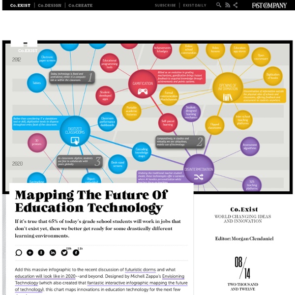
Budget Homeschool The Big Picture What Will The Ed Tech Revolution Look Like? During the past 40 years, accounting for inflation, we have nearly tripled the amount of money we spend per student in public K-12 education. It was roughly $4,000 in 1971, and last year amounted to $11,000 per student. Over that same period time, our students’ math and verbal test scores have remained unchanged. I am no Warren Buffett, but I can comfortably say to you that that is a lousy return on investment. In an increasingly competitive world, it is clear that our education system--as currently designed--isn’t sustainable. Simply throwing more money at a system that produces the same results is, well, not smart. In a perverse way, I believe federal and state budget cuts will help focus us on doing things differently and more efficiently. Similar to the consumer tech revolution, this ed tech revolution will take some time and happen unevenly in waves. First Wave (0 to 5 years from now): A Change in Perception Second Wave (5 to 10 years from now): A Change in Purchasing an Empowerment
Donna Young's Home School Weekly Lesson Planners Homeschool Weekly Lesson Plan Forms This web page has a selection of weekly homeschool lesson planner forms. Some of the forms have examples so you can see how one might use them. The PDF versions are meant to be filled out by hand. Most, but not all, of the forms on this page are included in DOC or RTF format in the word zipped package download. Legend Typeable PDF Acrobat PDF DOC or RTF Lesson Planners On This Page If you are new to making lesson plans, please visit this page: Homeschool Planning Help to learn how to make very simple plans from different types of books. One-Page Weekly Lesson Planners Basic Unlabeled Weekly Weekly Planner This is the basic weekly homeschool planner which has 5 columns and 8 rows. Basic Weekly [doc] Basic Weekly [rtf] Weekly "Class" Type-able PDF: This form is very similar to the one above except it is type-able. From Portfolio Set Not Quite Basic Weekly Planner Weekly Log The header reads: Weekly Log. Weekly Log [doc] Weekly Log [rtf] The Loved Edwardian Planner
“Paper Blog Foldable” illustrates parts of a blog » Miles' Tomes: Teaching and Learning Miles' Tomes: Teaching and Learning About Miles reBlogs « Learning Activities and Self-Reflection in Student Focused Assessment Model (pt3) Portfolios in Student Focused Assessment Model (pt4) » "Paper Blog Foldable" illustrates parts of a blog This little project helps students (and adults) get their heads wrapped around the vocabulary associated with blogging. You’ll need 3 pieces of paper, pencil, markers, pens (blue, black, and red), scissors, glue, and a ruler. Align two sheets of paper. Draw a straight line 3.5 cm from the top of the booklet along the short edge. Draw another line 3.5 mc from the open side of the booklet for the widget bar. Here are the lines sectioning off the banner and the widget area. Cutting only the top three pages, remove the long side for the side bar. Cutting only the top three pages, remove the banner area to the fold. Snip along the fold to remove the top three flaps for the banner area. On the larger back page, use the markers to create a blog banner. Email Print
Planning the High School Years – Part 5 - Homeschooling for Free If you’ve been following along with the Planning the High School Years series, you know that we’ve already covered creating a list of planned courses, keeping a transcript, and creating a high school portfolio. You’ve also gotten some great resources for free English and Algebra courses. In this post, as promised, you’ll get some great resources for free science and history classes for your high school students. Free Science Courses There are many different topics that high school students (especially those headed for college) need to take: Biology, Earth Science, Physics and Chemistry just to name a few. Free Biology Courses Boundless has a great Biology textbook that can be used for a high school course. For advanced students, check out the free Biology courses offered through OpenCourseWare at MIT. Free Earth Science Resources For the first free Earth Science course, we return to MIT courses. Here is a free high school Earth Science textbook that you can have your child use. is vital.