
Inuit Culture, Traditions, and History This picture shows several Inuit constructing an igloo with blocks of snow. Click on image for full size Library of Congress Prints and Photographs, Photograph by Frank E. Kleinschmidt Traditional Inuit way of life was influenced by the harsh climate and stark landscapes of the Arctic tundra – from beliefs inspired by stories of the aurora to practicalities like homes made of snow. Inuit invented tools, gear, and methods to help them survive in this environment. Geography Inuit communities are found in the Arctic, in the Northwest Territories, Labrador and Quebec in Canada, above tree line in Alaska (where people are called the Inupiat and Yupik), and in Russia (where people are called the Yupik people). Inuit Homes In the tundra, where Inuit communities are found, there are not many building materials. Getting Around To travel from one place to another, Inuit used sleds made of animal bones and skins pulled over the snow and ice by dogs. But that changed. Arctic Tundra The Cryosphere
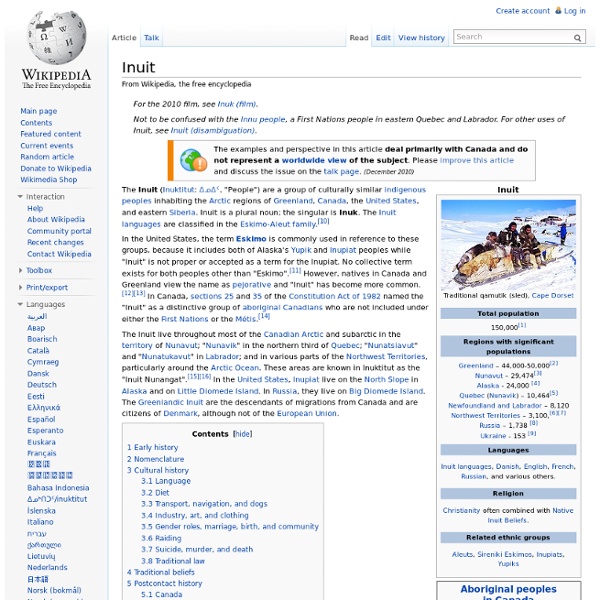
Inuit Indians Inuit The Inuit are a group of culturally similar indigenous peoples inhabiting the Arctic regions of Canada (Northwest Territories, Nunatsiavut, Nunavik, Nunavut, Nunatukavut), Denmark (Greenland), Russia (Siberia) and the United States (Alaska). Inuit means "the people" in the Inuktitut language. An Inuk is singular for Inuit person, whereas Inuit is plural. The Inuit language is grouped under Eskimo-Aleut languages. The Inuit live throughout most of the Canadian Arctic and subarctic: in the territory of Nunavut ("our land"); the northern third of Quebec, in an area called Nunavik ("place to live"); the coastal region of Labrador, in areas called Nunatsiavut ("our beautiful land") and Nunatukavut ("Our Ancient Land"); in various parts of the Northwest Territories, mainly on the coast of the Arctic Ocean and formerly in the Yukon. In the U.S., Alaskan Inupiat live on the North Slope of Alaska and Siberian Coast, Little Diomede Island. Early History Languages Writing Society, Marriage Diet
Arctic Location of the Arctic Artificially coloured topographical map of the Arctic region MODIS image of the Arctic Socially and politically, the Arctic region includes the northern territories of the eight Arctic states, although by natural science definitions much of this territory is considered subarctic. The Arctic region is a unique area among Earth's ecosystems. The cultures in the region and the Arctic indigenous peoples have adapted to its cold and extreme conditions. Etymology[edit] The word Arctic comes from the Greek ἀρκτικός (arktikos), "near the Bear, northern"[6] and that from the word ἄρκτος (arktos), meaning bear.[7] The name refers either to the constellation Ursa Major, the "Great Bear", which is prominent in the northern portion of the celestial sphere, or to the constellation Ursa Minor, the "Little Bear", which contains Polaris, the Pole Star, also known as the North Star.[8] Climate[edit] The Arctic's climate is characterized by cold winters and cool summers. Biota[edit]
Arctic Animal Printouts Advertisement. EnchantedLearning.com is a user-supported site. As a bonus, site members have access to a banner-ad-free version of the site, with print-friendly pages.Click here to learn more. (Already a member? Click here.) Arctic Animals The Arctic: The Arctic is a very cold, windy, and often snowy biome located around the North Pole. There is also a lot of land within the Arctic Circle (northern parts of Asia, Europe, and North America). Arctic Land Zones: The most extreme Arctic land (the closest to the North Pole) is called the High Arctic Zone; this polar desert supports very little animal or plant life (less than 5 percent of the land area is covered with vegetation) due to a very short, dry growing season, dry air, permafrost, poor soils, and a lack of pollinating insects. Arctic Animals: Animals that live in the Arctic (either full time or seasonally) are adapted to extreme conditions. Arctic Animal Printouts
Arctic Marine Mammals On Thin Ice The loss of sea ice due to climate change could spell disaster for polar bears and other Arctic marine mammals. Sea ice is the common habitat feature uniting these unique and diverse Arctic inhabitants. Sea ice serves as a platform for resting and reproduction, influences the distribution of food sources, and provides a refuge from predators. The Arctic undergoes dramatic seasonal transformation. "However, the rate and scale of current climate change are expected to distinguish current circumstances from those of the past several millennia. The April Special Issue of Ecological Applications examines such potential effects, puts them in historical context, and describes possible conservation measures to mitigate them. Climate change will pose a variety of threats to marine mammals. The effects of climate change will be compounded by a host of secondary factors. Lead authors of the collection of papers in the Special Supplement to Ecological Applications are:
Survival in the Arctic Human beings have lived in the Arctic and Subarctic for thousands of years. Their survival has been possible because there exists among them a profound understanding of the nuances within this extreme environment. Survival is also contingent on the relationship which exists between the human being and the animals, which provide major sources of food and clothing. Warmth for Hunters Caribou-skin or polar bear-skin clothing can provide warmth for a hunter who lies on the ice for hours waiting for his target to appear. Housing Finally, the most famous traditional example of housing is the snow house or "igluviga." Like many native cultures, the traditional northern peoples of the Arctic have survived in the most challenging of circumstances because of their deep understanding of the surrounding environment. Additional Resources: The Simcoe County Board of Education is constantly updating their home page available on the World Wide Web.
GeoScenic Home Page | British Geological Survey Welcome to GeoScenic, where you can view and download images from the vast collections of geological photographs in BGS. Download of 1000 x 1000 pixel images is free for all non-commercial use - all we ask in return is for you to acknowledge BGS when using our images. Click our Terms and Conditions link below for information on acknowledgement text, and to find out about using our images commercially. All images in this site can be viewed without registering. However, by registering, you can save images to your lightbox for future sessions and download images at your leisure. You are not currently logged in. Authors in all Elsevier journals can now include GeoScenic image identifiers from BGS (www.bgs.ac.uk) into their article on ScienceDirect. For more information on BGS GeoScenic identifiers and database linking with Elsevier please see Visit the new BGS Geoheritage image blog! View spatially referenced images on your mobile. J.D.
Unlocking the Archives Antarctica is the coldest continent - Russia's Vostok Station recorded the world's coldest temperature of -89°C in 1983. It is also the driest continent with an average annual snowfall of 125mm. It has no permanent inhabitants and it is the most isolated continent. It is of immense value to scientists for the study of climate change as it has an important effect on the world's climate and ocean systems. It was the geographers of ancient Greece who first suggested that there was a large landmass around the South Pole. In 1895, the International Geographical Congress claimed 'the exploration of the Antarctic region is the greatest piece of geographical exploration still to be undertaken' and the 'heroic' age of Antarctic discovery began. Discover the story of the race to the Pole. What were their views of Antarctica? What is the climate and landscape like? How has Antarctica been used for science? How has Antarctica been used for commercial profit?
Virtual Tour: Antarctica Before you start this tour, here are some things you should know: There is a way to get back to this page and a link to a site map of the virtual tour at the bottom of every page on this virtual tour. The tiny ("thumbnail") images of people and places found throughout this tour are meant to just give you the idea of the image; to retrieve the full-sized image, simply click on the thumbnail. Regardless of where you live or which country you work for, to get to the South Pole, you almost certainly go through New Zealand and then land at McMurdo on the coast of Antarctica on your way to the center of the continent and the bottom of the Earth: the South Pole. This image came from The Earth and Moon Viewer, specifically a request like this. Want to learn more about the territorial claims on Antarctica? Go on to New Zealand, McMurdo, and South Pole. All photos on this tour are from CARA unless otherwise specified. For more information
Discovering Antarctica - teaching and learning resources on Antarctica Antarctica Earth's southernmost continent Antarctica ()[note 1] is Earth's southernmost and least-populated continent. Situated almost entirely south of the Antarctic Circle and surrounded by the Southern Ocean (also known as the Antarctic Ocean), it contains the geographic South Pole. Antarctica is, on average, the coldest, driest, and windiest of the continents, and it has the highest average elevation. The ice shelves of Antarctica were probably first seen in 1820, during a Russian expedition led by Fabian Gottlieb von Bellingshausen and Mikhail Lazarev. Antarctica is governed by about 30 countries, all of which are parties of the 1959 Antarctic Treaty System. Etymology Belief by Europeans in the existence of a Terra Australis—a vast continent in the far south of the globe to balance the northern lands of Europe, Asia, and North Africa—had existed as an intellectual concept since classical antiquity. Geography East Antarctica comprises Coats Land, Queen Maud Land, Enderby Land, Mac. Present day