
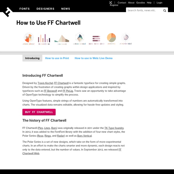
Emergent Futures Mapping with Futurescaper Futurescaper is an online tool for making sense of the drivers, trends and forces that will shape the future. As a user interface system, it still needs development. As a tool for analyzing and understanding complex systems, it works very well and does something I have yet to see anything else be able to do. Several people asked me about this after my last post, so here is some more detail. Following the logic of collective intelligence (as part of my my PhD), I broke up the the scenario thinking process into discrete chunks, came up with a system for analyzing and relating them together, and then distilled them into key outputs for helping the scenario development process. Emergent Thematic Maps One of the coolest things about Futurescaper is how it translates simple input into complex analysis, and then back again into simple insights. To demonstrate this, I tested the system using data from an International Futures Forum project on international climate change impacts for UK Foresight.
The Role of Public Health Informatics in Enhancing Public Health Surveillance July 27, 2012 / 61(03);20-24 Thomas G. Savel, MD Seth Foldy, MD Public Health Surveillance and Informatics Program Office (proposed), CDC Corresponding author: Thomas G. Public health surveillance has benefitted from, and has often pioneered, informatics analyses and solutions. This report proposes a vision for informatics in enhancing public health surveillance, identifies challenges and opportunities, and suggests approaches to attain the vision. The work of public health informatics can be divided into three categories. The informatics perspective can provide insights and opportunities to improve each of the seven ongoing elements of any public health surveillance system (3). Planning and system design – Identifying information and sources that best address a surveillance goal; identifying who will access information, by what methods and under what conditions; and improving analysis or action by improving the surveillance system interaction with other information systems. Vision
SVS Animation 3827 - Perpetual Ocean Short URL to share this page: Mission: Global Precipitation Measurement (GPM) Data Used: Hipparcos/Telescope/Tycho 2 Catalogue GTOPO30 Topography and Bathymetry ECCO2 High Resolution Ocean and Sea Ice Model 06/2006 - 12/2007 This item is part of this series: Flows Keywords: SVS >> Ocean DLESE >> Physical oceanography GCMD >> Earth Science >> Oceans >> Ocean Circulation GCMD >> Earth Science >> Oceans >> Ocean Circulation >> Ocean Currents NASA Science >> Earth GCMD keywords can be found on the Internet with the following citation: Olsen, L.M., G.
Three Innovations in Crowd Sourced Scenario Planning, Part 1 Part 1, An Introduction I’ve spent the better part of the last four years working on approaches to online scenario planning as part of my PhD. During this time I have designed and implemented three systems – each of which explored a different approach to crowd sourcing, engagement and online participation in futures work. I call these experiments in “large-scale participatory futures systems”. Over the next few weeks I will be writing these up for the blog. If people are interested, I might go back and explore some of the initial inspirations for these systems, as well as speculate on where this area might be going over the next few years. The Three Systems, an Overview The first system is called “Futurescaper” and was developed in partnership with the International Futures Forum (IFF), Tony Hodgson and my friend Nathan Koren. The second system is called “SenseMaker Scenarios“. The third system is called “FogCatcher”, and was developed with Anab Jain and Jon Ardern from Superflux.
The Fine Line In a Gray Area: When to Use Line vs Area Charts Line charts and area charts are very closely related. They are both good for time series data. They both show continuity across a dataset. They are both good for seeing trends rather than individual values. But they can’t always be used interchangeably, as they do have a few subtle — but important — differences. Line charts are good at showing multiple different series and comparing them against each other. Area charts are not as good at comparing between that many areas because they have problems with occlusion. These differences are mainly due to one simple change. Because of this potential for occlusion, one frequent thing to do with area charts is to stack them. There are two different ways to show this part to whole relationship, as well. Another, more subtle thing area charts can communicate is cumulativity. If used carefully, the interplay between rates and quantity can be represented very well with a combination line and area chart.
Wind Map An invisible, ancient source of energy surrounds us—energy that powered the first explorations of the world, and that may be a key to the future. This map shows you the delicate tracery of wind flowing over the US. The wind map is a personal art project, not associated with any company. We've done our best to make this as accurate as possible, but can't make any guarantees about the correctness of the data or our software. Please do not use the map or its data to fly a plane, sail a boat, or fight wildfires :-) If the map is missing or seems slow, we recommend the latest Chrome browser. Surface wind data comes from the National Digital Forecast Database. If you're looking for a weather map, or just want more detail on the weather today, see these more traditional maps of temperature and wind.
L'infographie dans la production du savoir En lisant un journal ou un magazine, peut-être avez-vous déjà eu l’impression que cartes et graphiques illustraient profusément les informations ? Sur Internet, peut-être avez-vous remarqué que diagrammes et animations – nouveaux outils incontournables pour présenter des données – surgissaient un peu partout sur l’écran ? Peut-être avez-vous lu dans le dernier manuel de journalisme que la recherche, « l’extraction de données » et leur visualisation, étaient les armes les plus affûtées du kit du journaliste post-moderne ? Illustration : © James Sillavan, 2012. Si tel est le cas, ou encore si vous avez ressenti, ne serait-ce qu’une fois dans votre vie, un attrait particulier pour des données présentées dans un graphique, c’est que vous êtes d’ores et déjà engagé dans la course frénétique à la production et à la consommation de ces nouveaux envahisseurs du monde de l’information : les infographies. Alors, comment s’y retrouver dans ce labyrinthe ? Mais ce n’est pas tout. Un changement radical
madrona spatial planning framework Features Madrona creates a system that can best be thought of as a feature spatial content management system. This starts with the Madrona PointFeature, LineFeature and PolygonFeature models. For more information consult the Madrona Feature documentation The madrona REST API is the communication channel for the client and server and supports both GeoJSON and KML. Create, read, update and delete Features Copy and share Features between user groups Manage Features within a FeatureCollection Convert to export formats Access reports and related documents Workspace Document The workspace document is an important part of the REST API. Because the API is well-defined through the workspace document, you can quickly and efficiently develop alternative client interfaces. For more information consult the Madrona workspace specification The JSON snippet below defines the wind energy site feature in the workspace document. 3D Web Client KmlTree KmlEditor KML Drawing Tools 2D Web Client GeoJSON Output
Civic Infographics — English By Giulio Frigieri The importance of perception for analysis and communication through infographics In his book “Graph design for the eye and mind”, Stephen Kosslyn asserts that “a good graph forces the reader to see the information the designer wanted to convey” and this would be the very “difference between graphics for data analysis and graphics for communication”[Kosslyn, 2006]. But are there any specific instances in which we can say that a data-based graphic is designed to describe, not to analyze? The fact that an explanatory text can be added – regardless of how concise or verbose it is – is not enough to imply that a chart’s nature is prevalently descriptive. In this line of thought, we must ask ourselves whether the two functional elements of analysis and communication can ever be separated, or even controlled. Line graphs – the most popular according to Edward Tufte [Tufte, 1983] – and bar charts, for example, are usually employed to describe. Sources: Kosslyn S.M. Fienberg S.
Facts About Dihydrogen Monoxide Dihydrogen Monoxide (DHMO) is a colorless and odorless chemical compound, also referred to by some as Dihydrogen Oxide, Hydrogen Hydroxide, Hydronium Hydroxide, or simply Hydric acid. Its basis is the highly reactive hydroxyl radical, a species shown to mutate DNA, denature proteins, disrupt cell membranes, and chemically alter critical neurotransmitters. The atomic components of DHMO are found in a number of caustic, explosive and poisonous compounds such as Sulfuric Acid, Nitroglycerine and Ethyl Alcohol. For more detailed information, including precautions, disposal procedures and storage requirements, refer to one of the Material Safety Data Sheets (MSDS) available for DHMO: Should I be concerned about Dihydrogen Monoxide? A similar study conducted by U.S. researchers Patrick K. Why haven't I heard about Dihydrogen Monoxide before? Good question. What are some of the dangers associated with DHMO? What are some uses of Dihydrogen Monoxide? Absolutely! Can using DHMO improve my marriage?