Astronomy
Astronomy is a natural science that is the study of celestial objects (such as moons, planets, stars, nebulae, and galaxies), the physics, chemistry, and evolution of such objects, and phenomena that originate outside the atmosphere of Earth, including supernovae explosions, gamma ray bursts, and cosmic background radiation. A related but distinct subject, cosmology, is concerned with studying the universe as a whole.[1] Astronomy is one of the oldest sciences. Prehistoric cultures have left astronomical artifacts such as the Egyptian monuments and Nubian monuments, and early civilizations such as the Babylonians, Greeks, Chinese, Indians, Iranians and Maya performed methodical observations of the night sky. During the 20th century, the field of professional astronomy split into observational and theoretical branches. Astronomy is one of the few sciences where amateurs can still play an active role, especially in the discovery and observation of transient phenomena. Etymology[edit]
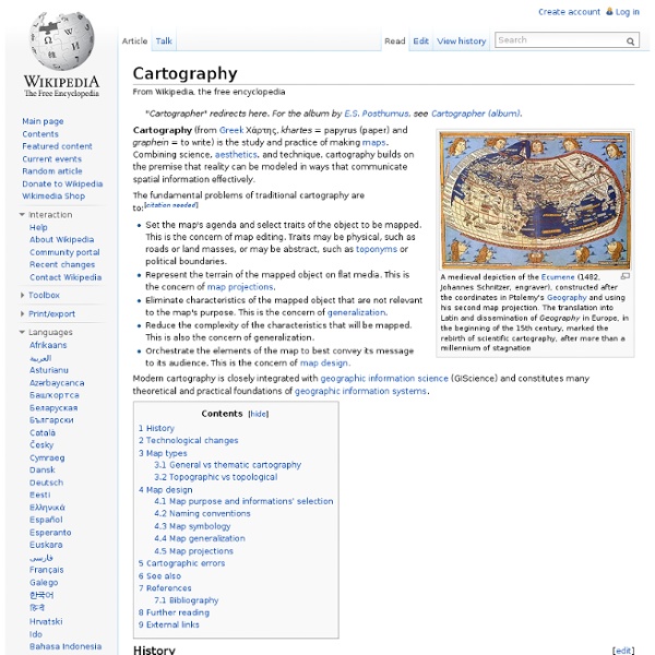
Knowledge Cartography
Human genome
The human genome is the complete set of genetic information for humans (Homo sapiens). This information is encoded as DNA sequences within the 23 chromosome pairs in cell nuclei and in a small DNA molecule found within individual mitochondria. Human genomes include both protein-coding DNA genes and noncoding DNA. Haploid human genomes (contained in egg and sperm cells) consist of three billion DNA base pairs, while diploid genomes (found in somatic cells) have twice the DNA content. The Human Genome Project produced the first complete sequences of individual human genomes. Although the sequence of the human genome has been (almost) completely determined by DNA sequencing, it is not yet fully understood. Molecular organization and gene content[edit] The total length of the human genome is over 3 billion base pairs. MiRNA, or MicroRNA, functions as a post-transcriptional regulator of gene expression. Coding vs. noncoding DNA[edit] Coding sequences (protein-coding genes)[edit] Table 2.
Antique Maps, Old maps, Vintage Maps, Antique Atlases, Old Atlases
Military technology
Military technology is the collection of equipment, vehicles, structures and communication systems that are designed for use in warfare. It comprises the kinds of technology that are distinctly military in nature and not civilian in application, usually because they are impractical in civilian application, have no legal civilian usage, or are dangerous to use without appropriate military training. It is common for military technology to have been researched and developed by scientists and engineers specifically for use in battle by the armed forces. Many new technologies came as a result of the military funding of science. Weapons engineering is the design, development, testing and lifecycle management of military weapons and systems. There are a significant number of military inventions whose technologies were originally developed and designed for military purposes, and which are now used by civilians with sometimes minor or no modifications at all. Vehicles and transports[edit]
The Collection
Neuroscience
Neuroscience is the scientific study of the nervous system.[1] Traditionally, neuroscience has been seen as a branch of biology. However, it is currently an interdisciplinary science that collaborates with other fields such as chemistry, computer science, engineering, linguistics, mathematics, medicine and allied disciplines, philosophy, physics, and psychology. It also exerts influence on other fields, such as neuroeducation[2] and neurolaw. Because of the increasing number of scientists who study the nervous system, several prominent neuroscience organizations have been formed to provide a forum to all neuroscientists and educators. History[edit] The study of the nervous system dates back to ancient Egypt. Early views on the function of the brain regarded it to be a "cranial stuffing" of sorts. The view that the heart was the source of consciousness was not challenged until the time of the Greek physician Hippocrates. Modern neuroscience[edit] Human nervous system
Glacier Bay National Park and Preserve - Mapping Coastal Resources at Glacier Bay
Introduction The 1989 Exxon Valdez oil spill (EVOS) demonstrated that accurate baseline information about existing coastal resources is crucial to managing the response, cleanup, and restoration of a major environmental disaster. One of the most important lessons that emerged from the EVOS experience is that an ongoing resources inventory and monitoring program is an absolute necessity for preparing ourselves for such "unscheduled events" as well as for general resource protection. A coastal resources inventory is one basic component of any program to protect Alaska's miles of pristine coastline. The Alaska Coastal Resources Inventory and Mapping Protocol provides coastal inventory information to resource managers to assist decision-making on issues such as: An article on this coastal inventory and mapping protocol appeared in the National Park Service's Natural Resource Year in Review--1997 (Yerxa 1998) with a mapping program update appearing in the 2002 issue (Vanselow 2003). Field Work
Livestock transportation
Sheep in a B Double truck, Moree, NSW, Australia Twelve pigs being transported to an auction sale. Livestock transportation is the movement of livestock, by ship, rail, road or air. Livestock are transported for many reasons, including but not limited to sale, auction, breeding, livestock shows, rodeos, fairs, slaughter, and grazing. Early records (USA only)[edit] The first known records of livestock transportation occurred in about 1607 on an English ship named the Susan Constant, which was transporting Jamestown bound colonists. 1800s[edit] Chicago’s meat exports had risen to almost 10% by 1848. 1900s[edit] By the early 20th century, railroads dominated the dressed meat market and the commodity trucking industry was in its infancy. Present day[edit] Sheep droving in Utah. Today most livestock and processed meat is transported by trucking companies that have specialized trailers for this purpose. See also[edit] Transhumance References[edit] Skaggs, J.
Digital World Tectonic Activity Map (DTAM)
The Digital Tectonic Activity Map (DTAM) is a new visualization tool for both researcher and educator alike to better understand tectonic activity of our planet for the past 1 million years. DTAM is a Geographical Information System (GIS) that displays a realistic synoptic view of present global tectonism by filling in the cartographic gap between conventional geological maps and plate reconstruction maps. The DTAM was created using current global datasets of seismicity, volcanism, and plate motions that were integrated with topography and bathymetry measurements derived from satellite gravity data. Macroscopic structural features were integrated via field studies from various researchers, space geodesy, and space-borne imagery (e.g. astronaut photography, Landsat). [Home], [ Background ], [ Datasets ], [ News ], [ Team ] Privacy Policy and Important Notices Civil Servant: Paul Lowman. Curator: Jim Roark .