
BBC - History - Pompeii: Portents of Disaster This Dynamic Earth--Contents [USGS] View of the planet Earth from the Apollo spacecraft. The Red Sea, which separates Saudi Arabia from the continent of Africa, is clearly visible at the top. (Photograph courtesy of NASA.) Ordering Instructions This book was originally published in paper form in February 1996 (design and coordination by Martha Kiger; illustrations and production by Jane Russell). U.S. or it can be ordered directly from the U.S. Call toll-free 1-888-ASK-USGS Or write to USGS Information Services Box 25286, Building 810 Denver Federal Center Denver, CO 80225 303-202-4700; Fax 303-202-4693 Version History Version 1.20 The online edition contains all text from the original book in its entirety. Linked Websites Please visit the Smithsonian Institution This Dynamic Planet website. See also This Dynamic Planet, the map showing the Earth's physiographic features, current plate movements, and locations of volcanoes, earthquakes, and impact craters.
Global Volcanic Hazards and Risk Originally prepared for the United Nations Office for Disaster Risk Reduction, this is the first comprehensive assessment of global volcanic hazards and risk, presenting the state of the art in our understanding of global volcanic activity. It examines our assessment and management capabilities, and considers the preparedness of the global scientific community and government agencies to manage volcanic hazards and risk. Particular attention is paid to volcanic ash, the most frequent and wide-ranging volcanic hazard. Of interest to government officials, the private sector, students and researchers, this book is a key resource for the disaster risk reduction community and for those interested in volcanology and natural hazards. A non-technical summary is included for policy makers. Reviews:
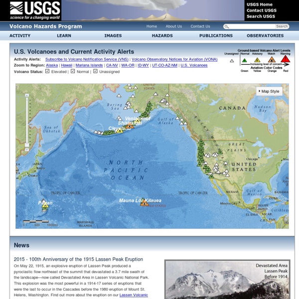
San Andreas Fault Homepage: Information, photos, maps, fault location and more! USGS Minerals Information: Mineral Commodity Summaries Published on an annual basis, this report is the earliest Government publication to furnish estimates covering nonfuel mineral industry data. Data sheets contain information on the domestic industry structure, Government programs, tariffs, and 5-year salient statistics for over 90 individual minerals and materials. Mineral Commodity Summaries (Complete) PDF Format, older editions: | 1997 | 1998 | 1999 | 2000 | 2001 | 2002 | 2003 | 2004 | 2005 | 2006 | 2007 | 2008 | 2009 | 2010 | 2011 | 2012 | 2013 | 2014 | 2015 | TXT Format: | 1996 | Appendixes PDF Format: | 1997 | 1998 | 1999 | 2000 | 2001 | 2002 | 2003 | 2004 | 2005 | 2006 | 2007 | 2008 | 2009 | 2010 | 2011 |2012 |2013 | 2014 | 2015 | 2016 | TXT Format: | 1996 | Individual Commodity Data Sheets MCS 2016 individual commodity sheets will be available in the first week of February, 2016.
Thuban is a former Pole Star | Brightest Stars Thuban is not a particularly bright star, but it holds a special place in the hearts of stargazers. That’s because Thuban was the Pole Star some 5,000 years ago, when the Egyptians were building the pyramids. Among the many mysteries surrounding Egypt’s pyramids are the so-called “air shafts” in the Great Pyramid of Giza. These narrow passageways were once thought to serve for ventilation as the pyramids were being built. The Great Pyramid of Giza, an enduring monument of ancient Egypt. This diagram shows the so-called air shafts in the Great Pyramid. One of the “air shafts” follows a crooked course through the Great Pyramid, so you couldn’t have sighted stars through it. The 26,000-year precession cycle causes the north celestial pole to move counter-clockwise relative to the backdrop stars. Earth never changes its axial tilt, but its axis does point out at different pole stars. Indeed, Thuban at times made a better pole star than our modern Polaris. How to see Thuban.
National boringsdatabase (Jupiter) Databasen indeholder information om mere end 280.000 boringer med oplysninger om blandt andet: teknisk opbygning af boringengeografisk placeringadministrative oplysningergeologisk beskrivelsevandstandspejlingergrundvandskemiske prøver og analyser Derudover indeholder databasen information om mere end 35.000 vandindvindingsanlæg (vandværker, markvandinsanlæg m.v.) med blandt andet: administrative oplysningerdrikkevandskemiske prøver og analyseroppumpede vandmængdertilladelser til vandindvinding Har du spørgsmål om indberetning eller brugen af Jupiter fra dit fagsystem, kan du kontakte os via jupiter@geus.dk.