
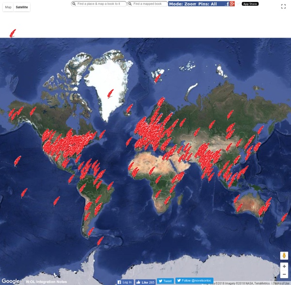
Map: Vaccine-Preventable Outbreaks | Map This interactive map visually plots global outbreaks of measles, mumps, whooping cough, polio, rubella, and other diseases that are easily preventable by inexpensive and effective vaccines. Red triangles indicate attacks on vaccinators and healthcare workers, as well as announcements from both governments and non-state actors that have had an impact—either positive or negative—on the successful implementation of vaccination programs. The Global Health Program at the Council on Foreign Relations has been tracking reports by news media, governments, and the global health community on these outbreaks since the fall of 2008. This project aims to promote awareness of a global health problem that is easily preventable, and examine the factors that threaten the success of eradicating preventable illnesses such as polio. Learn more about Global Health. On to the Vaccine-Preventable Outbreaks map
Homework and Study Help - Free help with your algebra, biology, environmental science, American government, US history, physics and religion homework Can I take a course at HippoCampus for credit? How do I enroll in a course at HippoCampus? Are there any fees to take your courses? How do I make a comment or ask a question? How do I get individual help with my homework assignment? What are the preferred texts? How can I use HippoCampus in my classroom? How can I use HippoCampus in my home school? Can I use the resources you have available for my homeschoolers? Do you know of any wet lab resources to accompany HippoCampus content? Is there a script, app, or something that can be used to track student use of HippoCampus? Can I share my HippoCampus content with my fellow teachers? Can I download the video? Can I change the size of the video window? Why won't the Environmental Science animations play? What if my page scroll bars or "submit" button are not showing? I can't find closed captioning. Where does the content from your site come from? There is an error in the multimedia presentation. How do I report a course errata item? No. AP Course Ledger
ESL Conversation Activity: Secret Sentence (Advanced) Instructions: This activity/game can be played according to topic and is best for advanced students. Put the students into groups (2 groups for smaller classes). One person from each group comes to the front of the class. Each student chooses a sentence strip and does not show the strip to each other or their teams. The teacher announces the topic and the two students start a conversation on the topic. At some point, the students have to slip their sentence into the conversation without anyone noticing. If the students think they hear the sentence, they say ‘stop,’ and the sentence needs to be repeated. Scoring: Guessing the ‘secret’ sentence= 1 point Use of the ‘secret’ sentence without detection= 1 point Failure to use the secret sentence= -1 point More printable Secret Sentences like these in The Great ESL Games Compendium! Secret Sentence - Samples by stickyball
mapFAST mapFAST Find library materials about world wide locations Find FAST Geographic Subject Headings Near: Terms of Use Map Satellite Share this Location: mapFAST is a project of OCLC Research. This prototype interface was developed to show the access opportunities created by using the fully enumerative faceted FAST subject headings. Learn more about the FAST project. The FAST authority file was developed jointly by OCLC and the Library of Congress and is available online to support FAST applications and allow potential users and other interested parties to view the FAST authority records. The most recent update for FAST was 11/05/2013. For comments on the FAST authorities or this interface, please contact the FAST Team FAST Projects searchFAST A full feature search interface to the FAST database. mapFAST mapFAST is a Google Maps mashup prototype designed to provide map based access to bibliographic records using FAST geographic and event authorities. FAST Converter FAST Linked Data mapFAST Web Service
Larry Ferlazzo, Teacher Email Newsletter Sign-Up And Site Blog Information Sign-Up for Email Updates From My Blog! This website is frequently updated so I have a daily blog where I highlight "Websites of The Day." I send out a free monthly short newsletter containing the "Top Ten" entries from my blog to people who don't want to receive daily updates. Few of the activities accessed by these links have been made by Mr. ArticlesShaking Up the ESL Classroom Building Cathedrals in the ESL Classroom Family Literacy, Computers, and ESL Samuel L. Audio (also see Podcasting)Partners in RhymeLanguage DialerSound SnapSoundboardFind SoundsSoungleJamendo BibliographyOttobibCitation MachineBibmeEasyBibMLA Citation GeneratorOSLIS Citation Maker Blank Maps Eduplace Outline MapsBlank Outline Maps of CountriesMap BankWorld AtlasOnline Map Bank Blogs -- ESLLearning the LanguageSecond Language WritingKeeping Up With the Web ChatboardsDave's ESL Cafe Discussion ForumTeachers.net ESL Chatboard Create PuzzlesPuzzlemaker
ESL Classroom Fun Teaching Tools - Game Count Down timers Free ESL/EFL Online & Classroom Games ESL Games World is the ultimate English learning fun lab with lots of interactive exercises for teachers and students of English. This site is brought to you free of charge by the same team that brought you the ESL-galaxy.com, englishmedialab.com and esltower.com. We are committed to making teachers' & students' lives a lot easier by providing useful free esl resources for teaching and learning English as a Foreign or Second Language. We have no doubt that you will find this website a handy tool for your teaching and learning of English. Some of the games include: Wheel of Fortune, Snakes and Ladders, Hangman, Memory Games, Spelling Games, Slot Machine, Word Classification Exercises and a host of others. ESL Powerpoint (PPT) Games If you are the type of person who prefers to have games on powerpoint or as printable handouts, we have been thinking of you. It is total fun and highly engaging fun lessons with these resources.
Historic Sites | Historic Holidays | Historical Places | Historvius SnappyWords Enduring Voices Project, Endangered Languages, Map, Facts, Photos, Videos Explore Talking Dictionaries The Enduring Voices team is pleased to present these Talking Dictionaries, giving listeners around the world a chance to hear some of the most little-known sounds of human speech. Several communities are now offering the online record of their language to be shared by any interested person around the world. While you probably won't walk away from these Talking Dictionaries knowing how to speak a new language, you will encounter fascinating and beautiful sounds--forms of human speech you've never heard before--and through them, get a further glimpse into the rich diversity of culture and experience that humans have created in every part of the globe. Explore the Talking Dictionaries for yourself. Losing Our World's Languages By 2100, more than half of the more than 7,000 languages spoken on Earth—many of them not yet recorded—may disappear, taking with them a wealth of knowledge about history, culture, the natural environment, and the human brain.
Graphwords NOS Special Projects - NOAA Historical Shoreline Survey Viewer What is a Shoreline Survey? Shoreline surveys (also called coastal surveys, T-Sheets or TP-Sheets, and shoreline manuscripts) refer to topographic sheets compiled from maps derived in the field with a plane table, in the office from aerial photos, or a combination of the two methods. These shoreline surveys are the authoritative definition of the U.S. high-water line and may also include details such as roads, prominent buildings, and other features along the coast. The surveys were used as base maps to construct nautical charts primarily used for navigation. The NOAA Historical Shoreline Survey Viewer Survey from 1885 for Dana Point, CA The NOAA Historical Shoreline Survey Viewer provides access to a large number of historical shoreline surveys conducted by NOAA and its predecessor organizations. Note, many of the scanned surveys have large file sizes, which have been reduced to more manageable preview sizes for Google Earth. Using the Shoreline Survey Google Earth Tool