
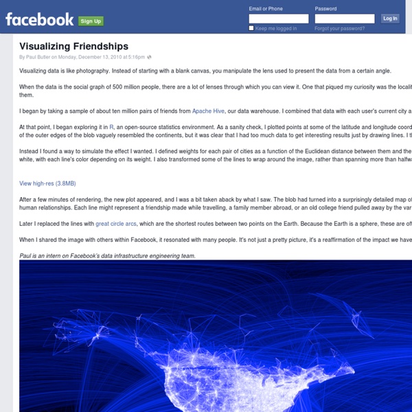
Visualization: Motion Chart - Google Charts Overview A dynamic chart to explore several indicators over time. The chart is rendered within the browser using Flash. Note for Developers: Because of Flash security settings, this (and all Flash-based visualizations) might not work correctly when accessed from a file location in the browser (e.g., rather than from a web server URL (e.g., This is typically a testing issue only. You can overcome this issue as described on the Adobe web site. Example (Note that the following code will not work when loaded as a local file; it must be loaded from a web server.) Loading The google.load package name is "motionchart". The visualization's class name is google.visualization.MotionChart. var visualization = new google.visualization.MotionChart(container); Data Format The first column must be of type 'string' and contain the entity names (e.g., "Apples", "Oranges", "Bananas" in the example above). Setting Initial State Methods Events
Visualisation graphique de l'info by vpatigniez on Genial.ly - Infographier des dépêches- Parcours d'images avec Pinterest- L'actu par la BD- Le rôle des images dans l'information scientifique- Interpréter et comprendre les sondages dans les médias- S'informer : du média au transmédia- Exploiter des données en classe- Intégrer les réseaux sociaux numériques dans la classe,1-Au programme,Présentation,Productions différenciées,Exemples,Exposés SVT 6è,EPI 3è,Stratégiesd'apprentissage- Affiche- Infographie- Dessin- Schéma- Padlet,Suivi/tableur visuel co-élaboré,Brochure "Médias&information : on apprend ! 2016-2017,Site du CLEMI,,Ressources,15-LE CLEMI, l'opérateur de l'EMI,Carte mentale,Infographie : "L'esprit critique face à la divinisation scientifique",,Ressources,Parcours CLEMI,L'esprit critique face à la divinisation scientifique,Faire exister mentalement pour inventer, découvrir,Dans les coulisses du Guardian Datablog,Slideshare par M.
Voici comment voir tout ce que Google sait sur vous (et paramétrer votre profil) L'adage est connu : "Google is watching you" ("Google vous surveille"). L'entreprise américaine basée dans la Silicon Valley, c'est un moteur de recherche bien sûr, mais aussi un service de messagerie (Gmail), un système d'exploitation pour téléphones portables (Android), la plate-forme de vidéos YouTube, le service Google Maps que vous utilisez parfois en guise de GPS dans votre voiture... Newsletter info Recevez chaque matin l’essentiel de l'actualité. OKNe plus afficher × Bref, Google est omniprésent dans votre vie et l'entreprise ne se prive pas de conserver toutes les informations possibles sur ses serveurs. >>> A lire également : Qu'est-ce que Facebook sait vraiment de vous? Histoire de rassurer ses utilisateurs, Google a annoncé le 8 septembre dernier la mise à jour de son "Dashboard", une sorte de tableau de bord rassemblant toutes les informations pour chaque internaute. Et enfin, pour faire une copie de toutes les données que Google conserve sur vous, c'est ici que ça se passe.
Visualisation de données des rumeurs sur Twitter ! Pendant les émeutes à Londres l’été dernier, beaucoup d’informations se sont propagées rapidement via Twitter sur ??ce qui se passait. Une partie de cette information était vraie et, comme souvent, l’autre partie était constituée de rumeurs, de choses fausses, etc. Le site du Guardian a donc mis en place une façon interactive afin d’explorer cette diffusion de l’information sur Twitter, et pour mieux comprendre comment la réalité et la fiction se révèlent par elles-mêmes Cette analyse basée sur de 2,6 millions de tweets nous suggère que les utilisateurs de Twitter sont capables de corriger la désinformation… jusqu’à un certain point bien-sûr ! Pour information, il faut savoir que chaque bulle représente un tweet et celui-ci est dimensionné par le nombre de retweet de ce tweet en question. source Ces articles peuvent aussi vous intéresser:
Vous connaissez les Graphiquants ? Ce blog Lien Le Web Vous connaissez les Graphiquants ? Process de création et de réalisation en image pour CANAL +, belle référence aux cartes heuristiques ! Advertising Agency: BETC EURO RSCG, Paris, France Executive Creative Director: Stéphane Xiberras Creative Director: Olivier Apers Art Directors / Copywriters: Gregory Ferembach, David Troquier Illustrator: Les Graphiquants Publié par Catherine Est Unanime à 6/05/2011 05:26:00 PM Envoyer par e-mailBlogThis! Libellés : agence, Art contemporain, campagne publicitaire, design et architecture, graphic design, illustration Liens vers cet article Créer un lien Article plus récentArticle plus ancienAccueil Vérifier la sécurité de nos communications De plus en plus de communications sont dématérialisées du fait de l'essor des moyens de communications numériques : email, messagerie instantanée, commerce en ligne, etc. Afin d'assurer la sécurité de ces échanges, de nombreux protocoles utilisant la cryptographie ont vu le jour. Il existe deux familles d'algorithmes de chiffrement : les algorithmes symétriques comme le chiffrement historique de Vigenère [4] ou AES [7] et les algorithmes asymétriques aussi appelés algorithmes à clé publique comme RSA [10]. Le chiffrement symétrique Dans un chiffrement symétrique, deux personnes souhaitent communiquer de manière chiffrée. Le chiffrement asymétrique Le chiffrement asymétrique fonctionne différemment. Le problème de l'échange de clé La cryptographie à clé publique permet à une personne d'envoyer une information chiffrée sans aucun échange au préalable, en utilisant par exemple le chiffrement RSA. Le protocole de Needham-Schroeder L'attaque « de l'homme du milieu » de Gavin Lowe
Vers un Nouveau Monde de données A l'occasion de la Semaine européenne des l'Open Data qui se déroulait à Nantes du 21 au 26 mai 2012, j'étais invité à faire une présentation sur le web des données, pour dépasser et élargir la problématique particulière de la réutilisation des données publiques. En voici la transcription. Nous sommes passés d'un web de l'information et de la connaissance à un web de données. "Les données sont le nouveau pétrole de l'économie", expliquait le consultant Clive Humby dès 2006. Le web est un écosystème de bases de données interconnectées. Tout est information. Le web est devenu "la base de données de nos intentions", affirmait John Battelle en 2003. La première des données, le pétrole non raffiné, est bien celle de nos comportements en ligne, ces milliards de clics que nous faisons sur le web à chaque instant. Mais ne nous y trompons pas. Il n'y a presque plus de données qui ne soient pas personnelles. Voici une application qui s'appelle SceneTAP. Tout est appelé à devenir des données.
Websites as graphs Everyday, we look at dozens of websites. The structure of these websites is defined in HTML, the lingua franca for publishing information on the web. Your browser's job is to render the HTML according to the specs (most of the time, at least). You can look at the code behind any website by selecting the "View source" tab somewhere in your browser's menu. HTML consists of so-called tags, like the A tag for links, IMG tag for images and so on. I've used some color to indicate the most used tags in the following way: blue: for links (the A tag)red: for tables (TABLE, TR and TD tags)green: for the DIV tagviolet: for images (the IMG tag)yellow: for forms (FORM, INPUT, TEXTAREA, SELECT and OPTION tags)orange: for linebreaks and blockquotes (BR, P, and BLOCKQUOTE tags)black: the HTML tag, the root nodegray: all other tags Here I post a couple of screenshots, and I plan to make the app available as an applet, so that anybody can look at their websites in a new way. cnn.com boingboing.net apple.com
What Makes A Good Data Visualization? — Information is Beautiful Hi there. I’m David McCandless, creator of this site and author of two infographic mega-tomes, Information is Beautiful (2009) and Knowledge is Beautiful (2014). I’ve created a lot of data and information visualizations. Around 540 over six years. (An eye-bleeding, marriage-crumpling average of 1.7 per week). There are 196 in my new book, Knowledge is Beautiful (out now). This graphic visualises the four elements I think are necessary for a successful “good” visualization. i.e. one that works. All four elements in his graphic seem essential. See how, interestingly, if you combine information & function & visual form without story, you get “boring”. Similarly, if you combine visuals, information & story without considering functionality and your goal, you get something useless. These elements form the backbone of my process and also what I teach in my dataviz workshops. I’m not really a follow-this-system type of person. Thanks,David
Unfiltered News. Visualiser l'actualité dans le monde sans filtres Unfiltered News est un incroyable site web qui permet de visualiser ce qui fait l’actualité dans la plupart des pays du monde à travers une carte interactive. Un outil qui permet de sortir de la bulle dans laquelle nous sommes enfermés par nos centres d’intérêt et surtout par notre situation géographique. Unfilitered News va nous faire prendre un peu de hauteur en nous proposant sur une carte les sujets d’actualité les plus importants dans la plupart des pays du monde ou en tout cas dans tous les pays couverts par Google Actualités. Car c’est avec les données de Google actualités que travaille ce service pour compiler et organiser toute l’information possible à un instant T. L’interface visuelle est une véritable réussite. Il s’agit d’une carte du monde dans laquelle vous allez pouvoir vous balader et zoomer à loisir. La taille de chaque mot clé est variable en fonction du nombre de récurrences dans les médias du pays. Unfiltered News est gratuit. Lien: Unfiltered News.
« Demandez à Clara » est en ligne : près de 5000 œuvres de compositrices disponibles Le festival « Présences féminines » a choisi le prénom de la célèbre compositrice pour sa nouvelle base de données consacrée aux compositrices. Des compositrices d’hier et d'aujourd’hui répertoriées sur une plateforme collaborative, évolutive et accessible à tous. Suzanne Gervais nous en avait annoncé le lancement dans une des premières chroniques de la saison, en août : la plateforme « Demandez à Clara ». La base de données en ligne, gratuite et participative, est entièrement consacrée aux compositrices. Elle tire son nom de Clara - Schumann évidemment -, qui avait fêté son 200ème anniversaire en 2019. Cette base de données inédite en France démarre fort : 4662 œuvres de 770 compositrices sont déjà référencées, et ce n’est qu’un début ! Pour écouter les morceaux, n’hésitez pas à faire un tour sur Soundcloud, où sont inscrites la plupart des compositrices contemporaines.
Éduthèque - Partenaire Arts et lettres Présentation de l’offre BnF - Éduthèque Au sein d'Éduthèque, la BnF donne aux enseignants la possibilité de télécharger plus de 30 000 images en haute définition issues du portail « classes.bnf.fr » et près de 350 vidéos. Les ressources BnF sont accessibles par le moteur de recherche fédéré ou par le portail « Classes ». L'offre pédagogique en ligne représente plus de 85 000 pages de dossiers, 65 000 images commentées, des albums iconographiques thématiques, des documents à explorer de manière interactive, des audiovisuels, des pistes pédagogiques, des ateliers et des jeux, des chronologies, des bibliographies, des fiches pédagogiques téléchargeables, des recherches guidées dans Gallica. Les thèmes traités s’organisent autour de six grands domaines : le livre et l’écrit, écrivains et conteurs, l’histoire des représentations, l’art et l’architecture, la photographie et la cartographie. Les dernières nouveautés de l'offre À noter : La BnF sur Internet