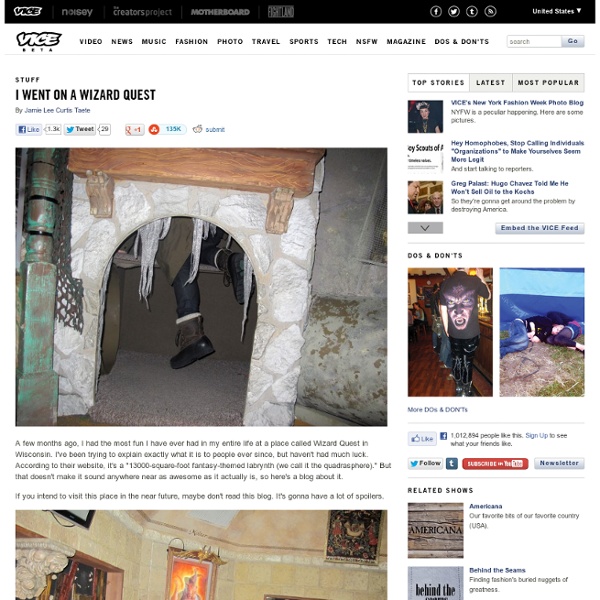
I Went on a Wizard Quest
Roadfood.com - The most memorable local eateries along the highways and back roads of America
Cheap Flights, Cheap Hotels, Price Predictor - Bing Travel
Google Maps Mania
Google adds Helicopter view to Google Maps
Google adds Helicopter view to Google Maps Google Maps are now enabled with helicopter view which allows you to view the route in an interactive 3d animation that can be paused and replayed too. Although only a select few might actually travel using a helicopter but helicopter view gives a nice aerial view of the area you will be passing through. User can choose any mode of transport and then choose to view the 3D animation of the route. If you like a particular area in your travelling route, you can pause the 3D animation and can explore that particular area in detail. When ready to move ahead, just click on resume to start the 3D animation from where you paused it. Google Maps Engineer ‘Paul Yang’ posted on Google Lat Long Blog “Getting directions is one of the most popular features on Google Maps, whether it be for driving, walking, biking or transit. Step1 : Plan the route Step2: Switch to 3d View to start the animation Step3: Pause the animation and view the surroundings
Maps with Street View
Alright everyone. Despite my complete melt-down further up in this comments thread, I need to put something out there. Disclosure first: although I have access to certain sources, I (and my business) am independent of Google but have direct dealings with Google. I have NDAs that prohibit me from disclosing certain things. I will mind my manners and my NDAs in writing this. August didn't go according to plan, completely. YouTube was very quick to adopt 360° video but YouTube is comparatively MUCH smaller than Google Maps and incorporating 360° video didn't require a major overhaul because it's still a niche and people are more forgiving of products that serve a niche. 360° photography, on the other hand, has moved from niche to mainstream and made the Street View brand (when tied directly and only to Maps) irrelevant very quickly. Transparency is crucial to Google's success. I think that's about it for now, believe me when I say that I'm not happy with the execution of this AT ALL.
Related:
Related:
