Cartes de France pour GPS Garmin
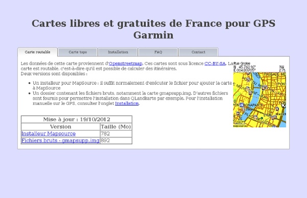
Pourquoi la carte n'est-elle pas complète ? Cette carte est basée sur les données OpenStreetMap. Le projet n'existant que depuis 2004, de nombreuses données manquent encore. Cependant, la progression est rapide et la majorité des grandes villes est déjà très bien couverte. Comment améliorer la carte ? En participant à OpenStreetMap ! vous pouvez envoyer toutes vos traces GPS sur Openstreetmap et tracer ainsi les chemins ou routes que vous avez déjà parcourus.pour la documentation, vous pouvez regarder le wiki Openstreetmap. La recherche de rue devrait normalement fonctionner, si la rue est présente sur la carte bien sur. Cependant, la carte est divisée en une centaine de morceaux, et la recherche d'adresse n'est possible que dans le morceau pris en référence par le GPS, par défaut celui dans lequel vous êtes. Vous pouvez trouver d'autres cartes sur cette page.
Freizeitkarte - Switzerland
Freizeitkarte - Switzerland (Release 14.03) Garmin GPS-device: Switzerland - install image for micro SD card (0.2 GB) Download Microsoft Windows: Switzerland - archive for Garmin BaseCamp (0.2 GB) Download Apple Mac OS X: Switzerland - install archive for Garmin BaseCamp (0.2 GB) Download All operating systems: Switzerland - image folder for QLandkarte (0.2 GB) DownloadWe wish you lots of fun with the Freizeitkarte maps ... and many interesting trips.
OSM Map On Garmin/Download - OpenStreetMap Wiki
Here are maps in Garmin image file format people have created from OSM data. Sites are listed by continent, then by country alphabetically, then by suspected usefulness (eg. sites which cover a whole continent and are updated regularly are listed first.) Maps offered worldwide or for a continent are often offering country downloads - hence they are only listed once and not for each region again. As OpenStreetMap is changing fast - only maps updated during the last 6 month should be listed. Permanently Dead links - please remove the entry. Maps are offered in different formats. To use gmapsupp.img maps, simply copy the "gmapsupp.img" file to your Garmin device. Older Garmin Devices The Garmin device loads a single map file called "gmapsupp.img". For instructions to make your own Garmin map from OSM data, see OSM Map On Garmin#Creating Your Own Maps from OSM Data. Worldwide Africa Asia Europe Several European Countries Single European Countries Oceania South America Central America Caribbean
Traces GPS. Vos randonnees a la trace avec GPX-View.com
Coordonnées GPS google et Altitude
Mapping Tools - OpenStreetMap Files Splitter
OpenStreetMap files are often too large for processing in Mapwel software in a direct, simple way. The world map in OSM file format currently has about 170 gigabytes. Users often need to process file that are hundreds or thousands of megabytes large. The OSM splitter is tool for division of large OpenStreetMap files into smaller tiles and their optional conversion into IMG and Mapwel MPW format. How to split the OSM file Use main menu > File > Open to open OSM file. Cropped area set so that polylines exceeding the area of interest are eliminated to reduce problems with coastline and sea objects generation. Click the Split button. If you split really large files (3 gigabytes or more), it is not recommended to use conversion to MPW and IMG format during splitting. Troubleshooting Error message Wrong coastline means that Mapwel software was not able to combine partial coastline polylines into filled polygons.
La-trace.com | Publier et partager des itinéraires VTT pour votre GPS
Free worldwide Garmin maps from OpenStreetMap
Related:
Related: