
Global trends reflect asymmetry in migratory movements Your privacy We value your privacy. We use cookies to ensure that we give you the best experience on our websites. polyline creation - How can I map a matrix of origins and destinations in QGIS? current community your communities Sign up or log in to customize your list. more stack exchange communities Stack Exchange circular_flow.wmv National income, output, and expenditure are generated by the activities of the two most vital parts of an economy, its households and firms, as they engage in mutually beneficial exchange. The primary economic function of households is to supply domestic firms with needed factors of production - land, human capital, real capital and enterprise. The factors are supplied by factor owners in return for a reward. Land is supplied by landowners, human capital by labour, real capital by capital owners (capitalists) and enterprise is provided by entrepreneurs. Firms
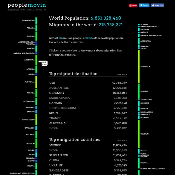
Origins and Destinations of the World’s Migrants, from 1990-2013 Select any country Please select a country on the map In 2013, people born in were living in other countries In 2013, people living in were born in other countries The figures in this interactive feature refer to the total number (or cumulative “stocks”) of migrants living around the world as of 1990, 2000, 2010 or 2013 rather than to the annual rate of migration (or current “flows”) in a given year. HTML5: Flow map of internal migration in England & Wales At the start of this year, I wrote a brief post on how we’ve been looking closely at the emergence of HTML5 as a visualisation platform. This week, we’ve published the first fruit of those labours – an interactive flow map of internal migration data for England & Wales: The aim here was to really stretch the technology and give it a tough visualisation challenge to see what it’s capable of. The underlying data used in the map contains over 60,000 migration flows – yet we have still managed to produce an interactive application that will run on an iPhone. I will aim to write some more details later on the development process and the good and bad experiences of transitioning from a platform like Flash. But the majority of solutions to our problems came from a general realisation that HTML5 doesn’t really exist at all, but is more an amorphous mixture of inter-related technologies and javascript libraries that are becoming increasingly cohesive as a development platform.
Looking back, ahead at federal taxing, spending Looking back, ahead at federal taxing, spending By John Waggoner, Julia Schmalz, Joshua Hatch and William Couch, USA TODAY This tax calculator will give you a rough idea of your federal tax bill — and where your tax money went — from 1940 through 2010. Caveats: The calculator is for a taxpayer who files individually, uses the standard deduction instead of itemizing, and has one exemption. The calculator also figures your Social Security and Medicare taxes. World Migration Map - Data Visualization by Metrocosm This map shows the estimated net immigration (inflows minus outflows) by origin and destination country between 2010 and 2015. Blue circles = positive net migration (more inflows). Red circles = negative net migration (more outflows). Each yellow dot represents 1,000 people. Hover over a circle to see that country’s total net migration between 2010 and 2015. Click a circle (or tap the circle twice on mobile) to view only the migration flows in and out of that country.
International Organization for Migration The GLOBAL MIGRATION FLOWS interactive app tracks migrants around the world. This application is now being hosted by IOM.int. It is endlessly fascinating to explore where we're from. The underlying data for the map was published by the UN DESA in 2015. Illustrating Flow: Two Methods for Wrangling Big Data The goal of the set of shipping mix maps, other than to distinguish between the types of shipment, was to try to tease out the de facto shipping lanes in addition to the well defined official shipping lanes. With one year of data (six million locations) we saw, as you might expect, a lot of activity around ports, a few surprisingly regimented lanes in established paths, and a diaspora of dots that if you squinted enough hinted at some worn paths. In order to make these paths more evident, which was the goal, we used a few methods -I'll tell you about two of the cooler ones. The shipping mix maps try to illustrate practical or unofficial seaways. Extrapolation The data had, in addition to other cool metrics, speed and direction information for each vessel position.
A Decade of Tax Cuts and Deficits The U.S. national debt’s path from $5.8 trillion in 2001 to $15.9 trillion as of Aug. 1, plus two opposite scenarios for how Congress could deal with the impending fiscal cliff. Photograph by Nicolas McComber/ISTOCK; Data: Congressional Budget Office, Congressional Research Service