
An Overview of Inca Tech Geography Drives Technology The Incas inherited an unforgiving geographic landscape. Despite its overwhelming beauty, its various terrains held hazards and risks. The Four Quarters of the Inca kingdom stretched along a narrow band of Pacific Ocean frontage extending from Chile up to Columbia, 2500 miles long, and ranging inland from the dry coastal desert to a fingerhold on Amazonian jungle. Elevations went from sea level to 22,000 feet, and while the highest zones were not regularly lived in, some housed ceremonial structures, and many of the people lived quite well at altitudes of 15,000 feet. Yet is is known that the people of the Inca were able to traverse their land from end to end, and from shore to highest regions, on a regular basis. Getting Around in the Andes The Incas under Pachacuti developed a lengthy system of roads. Bridges were built across ravines. There were approximately 2,000 tampos (rest houses) placed at even intervals along the trails. Working with Water
Inca Road System Construction and Lodging The Inca road system (called Capaq Ñan in Quechua and Gran Ruta Inca in Spanish) was an essential part of the success of the Inca Empire. The road system included an astounding 40,000 kilometers (25,000 miles) of roads, bridges, tunnels and causeways. Road construction began in the mid-fifteenth century when the Inca gained control over its neighbors and started expanding its empire; it ended abruptly 125 years later when the Spanish arrived in Peru. As a contrast, the Roman Empire built twice as many miles of road, but it took them 600 years. Four Roads from Cuzco The Inca road system runs the entire length of Peru and beyond, from Ecuador to Chile and northern Argentina, a straightline distance of some 3,200 km (2,000 mi). Chinchaysuyu, headed to the north and ending in Quito, Ecuador Cuntisuyu, to the west and to the Pacific coast Collasuyu, led southward, ending in Chile and northern Argentina Antisuyu, eastward to the western edge of the Amazon jungle Inca Road Construction Sources
NOVA | The Lost Inca Empire By Liesl Clark Posted 11.01.00 NOVA "Land of the Four Quarters" or Tahuantinsuyu is the name the Inca gave to their empire. It stretched north to south some 2,500 miles along the high mountainous Andean range from Colombia to Chile and reached west to east from the dry coastal desert called Atacama to the steamy Amazonian rain forest. At the height of its existence the Inca Empire was the largest nation on Earth and remains the largest native state to have existed in the western hemisphere. The wealth and sophistication of the legendary Inca people lured many anthropologists and archaeologists to the Andean nations in a quest to understand the Inca's advanced ways and what led to their ultimate demise. The Inca's engineering of roadways and agricultural terraces in mountainous terrain was one key to the expansion of the empire. opulent wealth While some remnants of the Inca's riches remain intact, many were destroyed as looters melted them down for their raw metal. Growth of an Empire
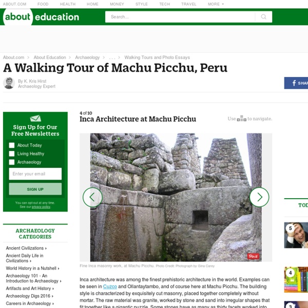
The Inca and Their Roads Now primarily a tourist attraction, Inca roads were once the arteries of a mighty Empire. Spanning a the continent lengthwise, the Inca road network covered approximately 22,000 miles of roads and trails with about half of that paved. They built stone surfaced roads where the terrain required it, but merely marked the way and distance on dessert or flat coastal terrain. Many miles of the Inca roads were captured from the civilizations they conquered. Some were built purely for ceremonial purposes, but the primary purpose of the roads was to hold the Empire together by providing vital arteries for communications and troop movements. The Inca Empire was less than a century old when conquered by the Spanish although Inca civilization before imperial expansion was significantly older. Inca civilization was based upon the deification of the Emperor who was said to be the Son of the Sun.
Inca Empire Timeline and King List Timeline and Kinglist of the Inca Empire The Inca word for ruler was 'capac', or 'capa', and the next ruler was chosen both by heredity and by marriage lines. All of the capacs were said to be descended from the legendary Ayar siblings (four boys and four girls) who emerged from the cave of Pacaritambo. The first Inca capac, the Ayar sibling Manco Capac, married one of his sisters and founded Cusco. The ruler at the height of the empire was Inca Yupanqui, who renamed himself Pachacuti (Cataclysm) and ruled between AD 1438-1471. High status women were called 'coya', and how well you could succeed in life depended to a degree on the genealogical claims of both your mother and father. Calendrical dates for the reigns of the various kings were established by Spanish chroniclers based on oral histories, but they are clearly miscalculated and so are not included here. Inca Kings Manco Capac (principal wife his sister Mama Occlo) ca. Classes of Incan Society
Quipu - Ancient Writing System of the Incas The Inca writing system called quipu (also spelled khipu or quipo) is the only known precolumbian writing system in South America—well, perhaps writing system isn't quite the correct phrase. But quipus were clearly an information transmittal system, and not just for the Inca. Instead of a clay tablet impressed with triangles like cuneiform, or a piece of paper with symbols written on it like Egyptian hieroglyphs, a quipu is essentially a collection of wool and cotton strings tied together, a knotted page of information which could be easily transported and easily translated across the wide expanses of South America. While scholars have yet to translate the quipu, we do know that information was embedded in the quipu in a number of different ways. Effects of the Spanish Conquest Quipus became known to Europeans in the 16th century, when the Spanish arrived in South America. It must be said: it was an incalculable loss to global society when the Spanish arrived in Cuzco in 1532. Sources
Lost Inca Gold -- National Geographic Steeped in death, conquest, desire, and mystery, the legend of the lost Inca gold is guarded by remote, mist-veiled mountains in central Ecuador. Somewhere deep inside the unforgiving Llanganates mountain range between the Andes and the Amazon is said to exist a fabulous Inca hoard hidden from Spanish conquistadors. The legend begins in the 16th century, when the great Inca Empire in western South America was giving way to European invaders. Atahualpa was an Inca king who, after warring with his half-brother, Huáscar, for control of the empire, was captured at his palace in Cajamarca in modern-day Peru by Spanish commander Francisco Pizarro. Pizarro agreed to release Atahualpa in return for a roomful of gold, but the Spaniard later reneged on the deal. He had the Inca king put to death before the last and largest part of the ransom had been delivered. 'Golden Vases Full of Emeralds' Treasure seeker Barth Blake followed up Spruce's discovery in 1886. Guide to Lost Inca Sites?
Viracocha And The Coming Of The Incas Sacred Texts Native American Index Previous Next from "History of the Incas" by Pedro Sarmiento De Gamboa, translated by Clements Markham, Cambridge: The Hakluyt Society 1907, pp. 28-58. THE NATIVES OF THIS LAND affirm that in the beginning, and before this world was created, there was a being called Viracocha. He created a dark world without sun, moon or stars. Owing to this creation he was named Viracocha Pachayachachi, which means "Creator of all things." Viracocha ordered these people that they should live without quarrelling, and that they should know and serve him. Some of the nations, besides the Cuzcos, also say that a few were saved from this flood to leave descendants for a future age. They say that in the time of the deluge called uñu pachacuti there was a mountain named Guasano in the province of Quito and near a town called Tumipampa. In the same way the other nations have fables of how some of their people were saved, from whom they trace their origin and descent. I. II.
Inca mathematics Version for printing It is often thought that mathematics can only develop after a civilisation has developed some form of writing. Although not easy for us to understand today, many civilisations reached highly advanced states without ever developing written records. The civilisation we discuss, which does not appear to have found a need to develop writing, is that of the Incas. The quipu was not a calculator, rather it was a storage device. The quipu consists of strings which were knotted to represent numbers. 586 on a quipu. For larger numbers more knot groups were used, one for each power of 10, in the same way as the digits of the number system we use here are occur in different positions to indicate the number of the corresponding power of 10 in that position. Now it is not quite true that the same knots were used irrespective of the position as would be the case in a true positional system. Now of course recording a number on a string would, in itself, not be that useful.