
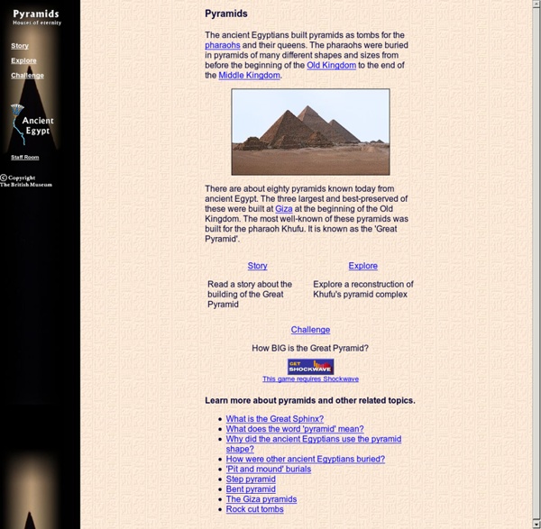
Encyclopedia Smithsonian: The Egyptian Pyramid The pyramids of Egypt fascinated travellers and conquerors in ancient times and continue to inspire wonder in the tourists, mathematicians, and archeologists who visit, explore, measure and describe them. Tombs of early Egyptian kings were bench-shaped mounds called mastabas. Around 2780 B.C., King Djoser's architect, Imhotep, built the first pyramid by placing six mastabas, each smaller than the one beneath, in a stack to form a pyramid rising in steps. This Step Pyramid stands on the west bank of the Nile River at Sakkara near Memphis. The transition from the Step Pyramid to a true, smooth-sided pyramid took placed during the reign of King Snefru, founder of the Fourth Dynasty (2680-2560 B.C.). The largest and most famous of all the pyramids, the Great Pyramid at Giza, was built by Snefru's son, Khufu, known also as Cheops, the later Greek form of his name. There has been speculation about pyramid construction. Websites and Books on Ancient Egypt (PDF) Unearthing Ancient Egypt (PDF)
Cartography Cartography (from Greek χάρτης khartēs, "map"; and γράφειν graphein, "write") is the study and practice of making maps. Combining science, aesthetics, and technique, cartography builds on the premise that reality can be modeled in ways that communicate spatial information effectively. The fundamental problems of traditional cartography are to:[citation needed] Set the map's agenda and select traits of the object to be mapped. Modern cartography is largely integrated with geographic information science (GIScience) and constitutes many theoretical and practical foundations of geographic information systems. History[edit] The earliest known map is a matter of some debate, both because the definition of "map" is not sharp and because some artifacts speculated to be maps might actually be something else. Mappa mundi are the Medieval European maps of the world. The Arab geographer Muhammad al-Idrisi produced his medieval atlas Tabula Rogeriana in 1154. Technological changes[edit] Map types[edit]
Suez Canal The canal is owned and maintained by the Suez Canal Authority[6] (SCA) of Egypt. Under international treaty, it may be used "in time of war as in time of peace, by every vessel of commerce or of war, without distinction of flag."[7] History[edit] Northern outlet of the Suez Nile–Red Sea Canal(s)[edit] Ancient west–east canals were built to facilitate travel from the Nile to the Red Sea.[8][9][10] One smaller canal is believed to have been constructed under the auspices of either Senusret II[11] or Ramesses II.[8][9][10] Another canal, probably incorporating a portion of the first,[8][9] was constructed under the reign of Necho II; however, the only fully functional canal was engineered and completed by Darius I.[8][9][10] 2nd millennium BC[edit] The legendary Sesostris (likely either Pharaoh Senusret II or Senusret III of the Twelfth dynasty of Egypt[11][12]) is suggested to have perhaps started work on an ancient canal joining the River Nile with the Red Sea (1897 BC–1839 BC). 165.
Dimensions of the Cheops (Khufu) pyramid and building materials involved. Numbers and figures of the Cheops (Khufu) pyramid: The pyramid of Khufu - Output / performance - Building material - Dimensions of the pyramid - Dimensions in Royal Cubits - Sources Cheops-pyramid (pyramid of Khufu) Of the the famous Seven Wonders of the Ancient World the Great Pyramid of Khufu (Cheops) at Giza is the only one still standing. The Giza pyramids must have made an incredible visual impact - at the edge of the desert three abstract geometrical symbols were rising, huge luminous white triangles reflecting the blinding light of the sun! The pyramids on the Giza plateau are with 146.59m (Khufu / Cheops) and 143.87m (Khafre / Chefren) respectively the largest, however there are over 30 major pyramids and a myriad of smaller pyramids in Egypt. Cheops-Pyramid 1. Output / performance Detailed calculations how many workers were necessary to build the pyramid Overview pyramid building Building materials for the Cheops-pyramid Quarrying stones for the pyramid Löhner's rope roll Sources
Egyptian Pyramids — History.com Articles, Video, Pictures and Facts No pyramids are more celebrated than the Great Pyramids of Giza, located on a plateau on the west bank of the Nile River, on the outskirts of modern-day Cairo. The oldest and largest of the three pyramids at Giza, known as the Great Pyramid, is the only surviving structure out of the famed seven wonders of the ancient world. It was built for Khufu (Cheops, in Greek), Sneferu’s successor and the second of the eight kings of the fourth dynasty. Though Khufu reigned for 23 years (2589-2566 B.C.), relatively little is known of his reign beyond the grandeur of his pyramid. The sides of the pyramid’s base average 755.75 feet (230 meters), and its original height was 481.4 feet (147 meters), making it the largest pyramid in the world. Three small pyramids built for Khufu’s queens are lined up next to the Great Pyramid, and a tomb was found nearby containing the empty sarcophagus of his mother, Queen Hetepheres. The middle pyramid at Giza was built for Khufu’s son Khafre (2558-2532 B.C).
Map Projections, Geography Glossary Advertisement. EnchantedLearning.com is a user-supported site. As a bonus, site members have access to a banner-ad-free version of the site, with print-friendly pages.Click here to learn more. (Already a member? A map is a representation of a place. Projections: Maps are called projections because map-makers have to project a 3-D surface onto a 2-D map. Since a map is 2-dimensional representation of a 3-dimensional world, compromises must be made in accuracy (some information must be lost when one dimension is ignored). Maps that accurately reflect area are often called equal-area maps (an example is the Albers equal-area conic map). Related Terms: The Children's University of Manchester
Explore Ancient Egypt Explore Ancient Egypt with our Interactive Map © 2012 This website is produced by the Student Recruitment, Admissions and International Development Division at The University of Manchester Cataracts of the Nile The six cataracts of the Nile Fourth Cataract Sixth Cataract The cataracts of the Nile are shallow lengths (or white water rapids) of the Nile River, between Aswan and Khartoum, where the surface of the water is broken by many small boulders and stones protruding out of the river bed, as well as many rocky islets. In some places, these stretches are punctuated by whitewater and are perhaps well characterized as rapids, while at others the water flow is smoother, but still shallow. The 6 cataracts[edit] Counted going upstream (from north to south), the First Cataract is in present day Egypt; and the Second through Sixth Cataracts are in Sudan. Characteristics[edit] The word cataract is a Greek word literally meaning "down-rushing", "rapids", "floodgate" or "waterfall". Despite these characteristics, some of the cataracts which are normally impassable by boat because of the shallow water have become navigable during the flood season. Notes[edit] External links[edit] Cataract photos links: