

Nominatim/Installation. This page describes the general installation process for Nominatim.
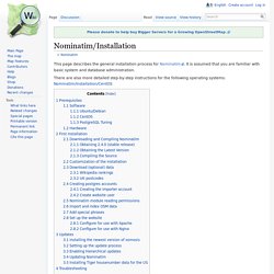
It is assumed that you are familiar with basic system and database administration. There are also more detailed step-by-step instructions for the following operating systems: Nominatim/Installation/CentOS Prerequisites Software Ubuntu/Debian In standard Debian/Ubuntu distributions all dependencies should be available as packages. Build your own OpenStreetMap Server - Ubuntu 08.04 Hardy Heron. This article is now archived as An updated (2010) article is based on Ubuntu 10.04 Lucid Lynx Build your own OpenStreetMap server.
Build your own what? OpenStreetMap is the editable World map of everything. It is the Wikipedia of maps. It is to other on-line maps as Wikipedia is to Britannica. OpenStreetMap is a massive project that started as Steve Coast's, frame-breaking idea in 2004. OpenStreetMap makes the data and the software available to you with Free Software and free data licenses so that you can use, learn from, teach with, improve upon and share with others what you gain from OpenStreetMap. The project operates on a massive scale as there is an incredible amount of data, there is more data every day, and there are more people using the data every day.
It does cover creating a single server from a typical PC circa 2006. OSM - GWR Street and Place Names Comparision. This site shows a comparison of named features in OSM to a list generated by the Federal Statistical Office from the Eidg.
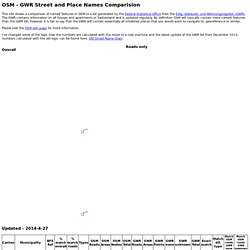
Gebäude- und Wohnungsregister (GWR). The GWR contains information on all houses and apartments in Switzerland and is updated regularly. By definition OSM will typically contain more named features than the GWR list, however it is fair to say that the GWR will contain essentially all inhabited places that you would want to navigate to, georeference or similar. Please visit the OSM wiki page for more information. I've changed some of the logic how the numbers are calculated with the move to a new machine and the latest update of the GWR list from December 2013, numbers calculated with the old logic can be found here: Old Street Name Stats Overall. Ch:current coverage. Current OSM coverage in Switzerland What has been done in Switzerland and what still need to be mapped ?
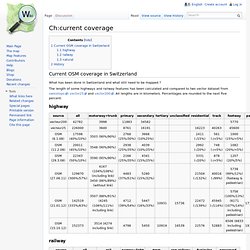
The length of some highways and railway features has been calculated and compared to two vector dataset from swisstopo: vector25 and vector200. All lengths are in kilometers. Percentages are rounded to the next five percent. highway railway natural History Here some nice History images. Serving Tiles. Tiles from a third-party provider are the simplest way to make the switch to OpenStreetMap, and offer clarity of cost.
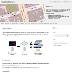
However, if you’d like to take full control of your destiny, you can render and serve your own tiles. This section explains how. Is it for you? Both generating and serving tiles incur significant hardware requirements, especially if you need global coverage and regular updates. If you are setting up your own tile server, we recommend that you use Ubuntu Linux. The options System requirements Serving your own maps is a fairly intensive task. We would recommend that you begin with extracts of OpenStreetMap data – for example, a city, county or small country – rather than spending a week importing the whole world (planet.osm) and then having to restart because of a configuration mistake!
The toolchain We use a series of tools for generating and serving map tiles. Apache provides the front end server that handles requests from your web browser and passes the request to mod_tile. Building a business on OpenStreetMap data? OpenCage Data wants to make that easier. OpenStreetMap is a fascinating phenomenon.

The eight-year-old crowdsourced geodata project is powering mapping apps (Skobbler and, in places, Apple Maps), recommendation tools (Foursquare), sports watches (Leikr), classifieds (Craiglist) and property search engines (Nestoria). However, given that OpenStreetMap data is both free to use and impressively detailed, how come even more businesses aren’t using its data? That’s the question Lokku, the London-based company behind Nestoria, asked itself when it switched from the Google Maps API to OpenStreetMap a couple of years back.
The problem, Lokku found, was the data was complex to use. Accuracy. See also: Quality assurance Accuracy of a map is as important as completeness.
This page discusses sources of error, and how correcting other peoples errors based on one source of data can be a problem. Refining accuracy wiki-style OpenStreetMap is still in the process of building basic map coverage in many areas. The degree of accuracy that is reasonable depends on the existing data. In areas where there is no coverage, even an inaccurate tracing of a road you know is there without GPS or other sources is an improvement. The more dense areas of our map tend to be those where many users have refined the data over time, in these areas you should probably be a bit more cautious when adding new data.
OpenStreetMap. Building a tile server from packages. If you’d like to build your own tile server, using packages can save you a good deal of installation work.
These packages work with Ubuntu Linux versions 12.04 LTS (Precise Pangolin) and above. After installation, you should have your own working tileserver with the standard OSM Mapnik stylesheet, into which you can import an extract of the OSM data for rendering. It is based on the same software that OSM’s own tile server uses: mod_tile for servingrenderd as the rendering daemonmapnik for the actual rendering The main aim of these packages is to simplify installation, by automating as much as possible into packaging scripts. Installation The following commands need to be entered into the terminal to set things up: