
PNY. The Discoverers of the Pacific map was published in December 1974 as half of a two-map set with the Islands of the Pacific map and the article “The Coming of the Polynesians.”
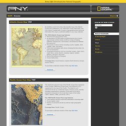
An educational work, this map contains an abundance of information about Pacific islanders, their shipbuilding techniques, types of canoes, and how they navigated using the stars, birds, and other natural data. Topic: Ocean Shallow Spots. “reclaim” it from the gringos!
Hawaii is 700 nm away! They wont even now we are there,…Plus, in case one of gets cancer, will have free, “natural chemo” there,… Ok, seriously now. In my book, the best spot is Saya de Malha Bank, the Northen Bank, around the Poydenot Rock. Thats a bit SE form Wolf Hilbertz “Autopia” site. What are they gonna do? Will be @ least the same as their defense budget. Scientific Explortation Foreign nations that wish to conduct scientific research in the EEZ or on the continental shelf of another nation may do so, but only with the consent of the other nation.
Yes, “Nations may reject a requests by a foreign nation for access to their EEZ or continental shelf if the project: …… 3) involves the construction or use of artificial islands. In time our relation with Mauritius will turn into a partnership, and from there, sovereignty is just around the corner. Odin Encyclopedia - Saya de Malha Bank. Details Category: Marine Biology Published on Friday, 06 July 2012 15:41 Written by Jose Carlos Palma Hits: 137 The Saya de Malha Bank (also Sahia de Malha Bank, Modern Portuguese: saia de malha, English mesh skirt) is the largest submerged bank in the World, part of the vast undersea Mascarene Plateau. Seafloor - 2/2 - The Watchers. Pacific Ocean Floor Map - pacific ocean. Topographic maps world-wide. Terms of Use Scale = 1 : 222m z:2 5000 km 2000 mi Base Layer Topographic Maps (Zoom In) Physical Relief Map Google Street Map Google Hybrid Map Google Terrain Map Bing Street Map Bing Hybrid Map Yahoo Street Map Yahoo Hybrid Map OpenStreetMap (Mapnik) OpenStreetMap (Tiles@Home) Overlays Labels (for reliefmap) Image data hosted by Atlogis Click here for URL-Link of this View | Topographic Maps Coverage | Soviet Military Maps Documentation | Atlogis Map Shop.
North Austral hotspot. Le fond des mers et des océans. C'est en lisant un bouquin qui présentait une carte mondiale de la GEBCO (General Bathymetric Chart of the Oceans) que j'ai eu l'idée de vous proposer ce sujet En constatant que la surface notre planète est majoritairement composée d'eau.
Qui ne s'est jamais demandé à quoi pouvait bien ressembler la terre sous la mer ?????? Google Earth ne nous donne pas encore d'image précise de cette cartographie très particulière. Bien sûr à différents endroits du globe, sortent des océans telle ou telle ile mais ce que je vais essayer de vous transmettre ici c'est une découverte progressive de l'étendue des plateaux et des bassins océaniques, la profondeur des fosses et la taille des dorsales qui jalonnent les fonds sous-marins. Source : Atlas des mers et des océans - GEO - Editions SOLAR. Pour commencer voyons de plus près le Nord-Est de l'Océan Atlantique Au pied du talus se sont accumulés, pierres, graviers, sable et vase provenant soit du plateau continental, soit du talus.
Seamount Catalog. 3-D visualisation of the GEBCO_08 Grid. The following 3-D views were produced from the GEBCO_08 Grid.
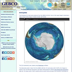
Click on the large image to download a large version of the image in Adobe Acrobat .pdf format. Move Antarctica and Southern Ocean Arctic Ocean Atlantic Ocean Eastern Pacific Ocean Indian Ocean Western Pacific Ocean The 3D-visualisation was created using Fledermaus software. The bathymetry data is taken from the GEBCO_08 Grid. President Thiers Seamount. Saya de Malha Bank. Saya de Malha Location of Saya de Malha in the Indian Ocean Map of Saya de Malha The bank covers an area of 40,808 km2 (15,756 sq mi),[1] and is composed of two separate structures, the smaller North Bank (also called Ritchie Bank), and the huge South Bank.
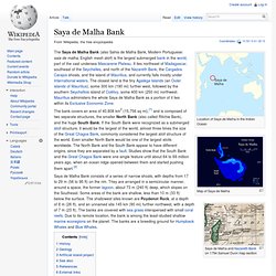
If the South Bank were recognized as a submerged atoll structure, it would be the largest of the world, almost three times the size of the Great Chagos Bank, commonly considered the largest atoll structure of the world. Even smaller North Bank would be one of the largest atolls worldwide. Saya de Malha Bank consists of a series of narrow shoals, with depths from 17 to 29 m (56 to 95 ft) on the rim.