
Shogran, Naran 19 Insider Tips, Photos and Reviews. Shogran is one of the most beautiful plateau in the whole area with an altitude of 7,749 feet (2,362 meters) above sea level.
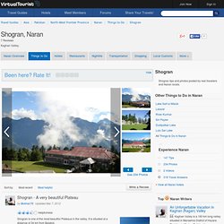
It is 33 km from Balakot via Kawai. Take this steep road from Kawai for Shogran. The distance is 5 miles and climb is 3,000 feet. Mighty Himalayan peaks like Musa Da Musallah 14,498 feet (4,419 m), Malka Parbat 17,156 feet (5,229 m) and Makra 15,030 feet (4,581 m) could be seen from Shogran. Sri/Paya and Dona Meadows are most popular spots near Shogran. For those who like adventure, Sharan could be good option. Shogran's real asset are the views it offers. Makra Peak. Makra is a scenic peak in the Hazara region of the Himalayas in northern Pakistan.
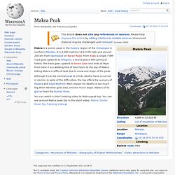
It is 4,000 metres (13,123 ft) high and almost 200 km from Islamabad on Naran Road. From Kiwai a single 7-KM road goes upwards to Shogran, a tourist place with plenty of hotels; the track goes upward to Seree Lake and ends at Paye. From here it is a walking trek of four hours to the top of Makra. Hiking Makra is difficult task due to snow and slope of the peak.
Although it can be normal peak to climb, deaths have occurred in storms. You can watch a short trekking video to Makra peak top. Www.sdpi.org/publications/files/PFD april-June-2010.pdf. Urban.unhabitat.org.pk/Portals/0/Portal_Contents/KPK/Mansehra/Mansehra City Profile by NED.pdf. Www.erra.pk/Reports/KMC/MansehraProfile200907.pdf. Visit Kaghan. Mapping and Documentation of the Cultural Assets of Kaghan Valley - Balakot Tehsil. Mapping and Documentation of the Cultural Assets of Kaghan Valley Book: Balakot 34-35 CHAPTER Four Cultural Assets of Kaghan 4.1 Folk Lore’s in 1976 were a tehsil of Hazara district.
After the 1981 census of Pakistan it was Mapping And Documentation Of The Cultural Assets Of Kaghan Valley: and Documentation of the Cultural Assets of Kaghan Valley, Mansehra.pdf Download PDF Mapping and Documentation of the Cultural Assets of Kaghan Valley 8.8 out of 10 based on 26 ratings. Vote: 12345 Related to Mapping and Documentation of the Cultural Assets of Kaghan Valley: © Free Analysis Books 2010 All Free Analysis Books ebooks are the property of their respective owners. Mapping and Documentation of the Cultural Assets of Kaghan Valley PDF Ebook. Kaghan Valley. Kawai, Kaghan Valley The Kaghan Valley (Urdu: وادی کاغان ) is a valley in the north-east of Mansehra District of the Khyber Pakhtunkhwa Province of Pakistan.
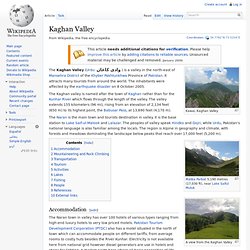
It attracts many tourists from around the world. The inhabitants were affected by the earthquake disaster on 8 October 2005. The Kaghan valley is named after the town of Kaghan rather than for the Kunhar River which flows through the length of the valley. The valley extends 155 kilometers (96 mi), rising from an elevation of 2,134 feet (650 m) to its highest point, the Babusar Pass, at 13,690 feet (4,170 m). The Naran is the main town and tourists destination in valley. A view from the Kaghan Valley Accommodation[edit] The Naran town in valley has over 100 hotels of various types ranging from high-end luxury hotels to very low priced motels.
Some hotels are also located in Kaghan village and Shogran. Mountaineering and Rock Climbing[edit] Kaghan Valley has a lot of potential for mountaineering and rock climbing. Transportation[edit]