
Dans les pas du Seigneur des anneaux avec Google Street View. Randonneurs, fans de Hobbits...

Pour bien commencez 2016, des cascades luxuriantes de la Milford Track aux sommets alpins du Kepler Track, partez explorer la nature sauvage de la Nouvelle-Zélande en suivant l’une des sept «grandes promenades" sur Google Street View, en imagerie panoramique à 360 degrés. En suivant le Heaphy Track vous aurez peut-être l’impression de suivre les personnages du Seigneur des anneaux de Tolkien. C’est notamment là que Peter Jackson a tourné la trilogie. Quand le gouvernement réinvente la Terre du Milieu pour décrire sa politique. "Les limbes des normes obscures" ont remplacé le Mordor.
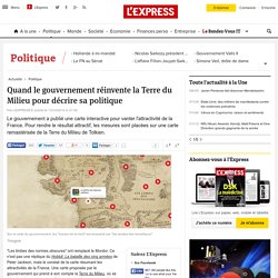
Ce n'est pas une réplique du Hobbit: La bataille des cinq armées de Peter Jackson, mais le constat de la carte résumant les attractivités de la France. Une carte proposée par le gouvernement qui prend à son compte la Terre du Milieu, où se déroulent les aventures du Seigneurs des Anneaux et du Hobbit. Un moyen de rendre plus attractif non pas les aventures de Bilbon Sacquet, mais l'agenda des réformes de Manuel Valls. Une annonce un peu fade, qui doit être plus séduisante ave ce format surfant sur l'actualité cinématographique du moment.
Pour agrandir la carte, cliquez ici. Si chacun se fera sa propre opinion, les fans de la saga peuvent s'amuser à comparer les noms choisis par le gouvernement pour rebaptiser certaines régions de la Terre du Milieu. Et à ce petit jeu-là, le frondeur PS, Jérôme Guedj, n'est pas en reste. Pour le reste, c'est l'étonnement qui prime. Vidéos à voir sur ce thème. Le Hobbit : La désolation de Smaug - Un périple à travers la Terre du Milieu. MeDEM - The Middle Earth Digital Elevation Model Project. Outerra - Minus.com. The Shire Years - Hobbiton and the Hill. Hobbitbagendalrg6.jpg (1500×1544) The-fantasy-world-map.png (500×553) Map.jpg (Image JPEG, 1065x1650 pixels) - Redimensionnée (39%) Lotr_map.jpg (2482×3579) Middle-Earth was Europe? « Ramblings of a Ragamuffin Child. March 20, 2010 by Becky K.
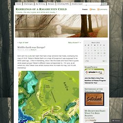
Kent sent me a site last night that had a map someone had made, overlaying the map of J.R.R. Tolkien’s Middle Earth on a map of Europe as it was supposed to be 6000 years ago. I find it interesting, since I like the books and have tried to guess what people groups Tolkien’s different races corresponded to. I’m sure, as all writers do, that Tolkien took artistic license when he made his map, but it’s still interesting! “Created by Tolkien somewhere in the 1930s, the map shows the ‘mortal lands’ of Middle-earth, which according to Tolkien himself is part of our own Earth, but in a previous, mythical era. Tolkien didn’t create Middle-earth ex nihilo: ancient Germanic myths divide the Universe in nine worlds, inhabited by elves, dwarves, giants, etc. The Hobbits are described as inhabiting ‘the North-West of the Old World, east of the Sea’, and therefore it’s tempting to associate their home with Tolkien’s own, England.
Like this: Like Loading... 121 - Where On Earth Was Middle-earth? The millionth hit on this blog is as good an occasion as any to finally broach the inevitable subject for a blog about curious cartography: Middle-earth.
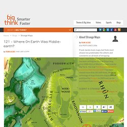
J.R.R. Tolkien’s invented mythology centred on an epic story of the struggle between Good and Evil, but it also included an elaborate backstory, a complex of languages, genealogies, cultures and peoples – and a map. Created by Tolkien somewhere in the 1930s, the map shows the ‘mortal lands’ of Middle-earth, which according to Tolkien himself is part of our own Earth, but in a previous, mythical era. At the time of the events described in ‘The Hobbit’ and ‘The Lord of the Rings’, Middle-earth is moving towards the end of its Third Age, about 6.000 years ago. Middle-Earth.jpg (Image JPEG, 1013x1015 pixels) - Redimensionnée (62%) The Grey Havens - Middle-earth: Was the northwest of Middle-earth meant to actually be Europe? From: The Tolkien FAQ by William D.B.
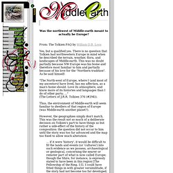
Loos Yes, but a qualified yes. There is no question that Tolkien had northwestern Europe in mind when he described the terrain, weather, flora, and landscapes of Middle-earth. This was no doubt partially because NW Europe was his home and therefore most familiar to him and partially because of his love for the "Northern tradition". As he said himself: "The North-west of Europe, where I (and most of my ancestors) have lived, has my affection, as a man's home should. Thus, the environment of Middle-earth will seem familiar to dwellers of that region of Europe (was Middle-earth another planet?).
However, the geographies simply don't match. In one letter he provided indications to help in visualizing the circumstances of various locales, but this does not help in resolving the above matter, since again northwestern Europe was used for comparison rather than equation: Middle-earth.jpg (Image JPEG, 1400x1414 pixels) - Redimensionnée (44%) Carte de la Terre du Milieu Version 7 Interactive. Map2.JPG (Image JPEG, 2328x1859 pixels) - Redimensionnée (33%) Cartes. Cartes. Cartes. Cartes. Carte Aman-Terre du Milieu.