
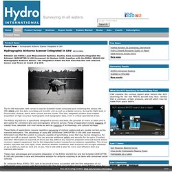
3D printable Drone It Yourself kit turns mundane objects into flying machines (video) Hydrographic Airborne Scanner Integrated in UAV - Product News - Hydro International. The S-100 helicopter UAS carried a special Schiebel-made composite pod containing the sensor, the IMU-GNSS unit, the data recording and transfer unit as well as a digital camera, during the flight tests in Grossmittel, Austria, which were carried out this month.
This fully integrated system thus enables acquisition of high-accuracy hydrographic and topographic data, even in critical operational areas. Trimble talks UAVs, upside-down scanners, and new software features. Mini-UAV-based photogrammetry and laser scanning. NIFTi UAV - Mosquito - performs 2D mapping and 3D perception using Hector SLAM. Autonomous Aerial Navigation in Confined Indoor Environments.
A Swarm of Nano Quadrotors. UAV 3D Pointcloud Flythrough. MIT's quadcopter with laser scanning for indoors navigation. UAV scales new heights as 3D architecture tool. Video transcript Scaling new heights in the world of 3D architecture - pilotless drones may be the key to unlocking the hidden details of historic buildings and monuments.

UAVs - or Unmanned Aerial Vehicles - more commonly conjure images of covert military operations. But this miniature drone being developed at Spain's University of Granada is being used to scan buildings to construct 3D models. Antonia Moraeles Garcia from Intelligenia Dynamics, the company building the prototype UAV, says the drone's unique features give it the stability to make accurate scans.
(SOUNDBITE) (English) ANTONIA MORAELES GARCIA, CEO OF INTELLIGENIA DYNAMICS, SAYING: "It has eight different rotors and the battery pack that goes back here can be fast trap and it also has GPS which comes here. Quadcopters Make 3D Scans Of Historic Buildings. The heck with cranes and scaffolds, the University of Granada is using quadcopters to shoot images of historic buildings and digitize them to 3D.
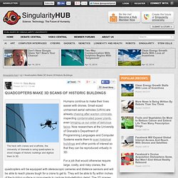
Humans continue to make their lives easier with drones. Small-sized unmanned aerial vehicles (UAVs) are already chasing after wanton criminals, inspecting contaminated power plants, even bringing us our order of delicious tacos. Now researchers at the University of Granada’s Department of Programming Languages and Computer Systems wants them to scan historical buildings and other points of interest so that they can be reproduced virtually in 3D. For a job that would otherwise require large, costly, and risky cranes, the quadcopters will be equipped with stereoscopic cameras and distance sensors and will be able to reach places tough for a crane to get to. They will be able to fly within inches of the building surface or monuments to capture high-definition detail. Kinect-carrying drone automatically builds 3D maps of rooms. Google Street View eat your heart out: An MIT-built quadrocopter uses Microsoft Kinect, and some smart odometry algorithms, to fly around a room and spit out a 3D map of the environment.
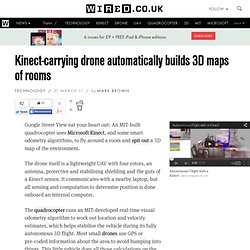
The drone itself is a lightweight UAV with four rotors, an antenna, protective and stabilising shielding and the guts of a Kinect sensor. It communicates with a nearby laptop, but all sensing and computation to determine position is done onboard an internal computer. The quadrocopter runs an MIT-developed real-time visual odometry algorithm to work out location and velocity estimates, which helps stabilise the vehicle during its fully autonomous 3D flight. Most small drones use GPS or pre-coded information about the area to avoid bumping into things. This little vehicle does all those calculations on the fly. Odometry is the process of using data from some kind of sensor to figure out position, like measuring how far a robot's legs or wheels have moved to determine how far it has travelled.
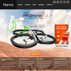
DroneMapper Aerial Imagery Processing and Photogrammetry. AR.Drone 2.0. Parrot new wi-fi quadricopter - AR.Drone.com - HD Camera - Parrot. “Create high-quality and stable movie shots” The Director mode lets you program automaticmovements so that you can shoot great videos justlike a movie director.
Choose your movement: traveling, pan, crane… Adjust speed and moves in real time to compose your video sequence Stabilization system and video post-processing to get clean smooth shots Tune camera settings such as white balance, exposure and luminosity Selection of key sequences in the video Video sharing on YouTube and AR.Drone Academy *In-app purchase on ar.freeflight Learn more. 30 minutes flight time for the AR.Drone with Zippy 2200mAh. DJI announces stabilized HERO mount, and camera-equipped Phantom quadcopter - Images. Well, that didn’t take long.

Just this January, DJI Innovations released its GPS-enabled Phantom quadcopter. Now, at this week’s National Association of Broadcasters show in Las Vegas, the company has unveiled a self-stabilizing camera mount that can be added to existing Phantoms, plus an upgraded Phantom that includes its own HD video camera. Additionally, DJI’s new iOS app allows users to view onboard video output in real time on their iPhone, iPad or iPod touch via Wi-Fi. One of the big selling features of the Phantom has been its included mount for the GoPro HERO actioncam. Unfortunately, as I discovered when doing my review of the Phantom, the existing mount allows vibrations to travel from the aircraft into the camera, creating jiggly video distortion known as the Jell-O effect. Hexakopter - 3D Mapping Demo.